Odaville, West Virginia
| Odaville, West Virginia | |
|---|---|
| Unincorporated community | |
 Odaville, West Virginia  Odaville, West Virginia | |
| Coordinates: 38°55′57″N 81°38′26″W / 38.93250°N 81.64056°WCoordinates: 38°55′57″N 81°38′26″W / 38.93250°N 81.64056°W | |
| Country | United States |
| State | West Virginia |
| County | Jackson |
| Elevation | 623 ft (190 m) |
| Time zone | UTC-5 (Eastern (EST)) |
| • Summer (DST) | UTC-4 (EDT) |
| Area code(s) | 304 & 681 |
| GNIS feature ID | 1555257[1] |
Odaville is an unincorporated community in Jackson County, West Virginia, United States. Odaville is located on the Left Fork Sandy Creek and County Highway 21 8.7 miles (14.0 km) north-northeast of Ripley.[2] Odaville once had a post office, which is now closed.[3]
References
- ↑ "Odaville". Geographic Names Information System. United States Geological Survey.
- ↑ Jackson County, West Virginia General Highway Map (PDF) (Map). West Virginia Department of Transportation. 2011. p. 1. Retrieved April 25, 2012.
- ↑ "Odaville Post Office (historical)". Geographic Names Information System. United States Geological Survey.
Municipalities and communities of Jackson County, West Virginia, United States | ||
|---|---|---|
| Cities | 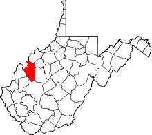 | |
| Unincorporated communities |
| |
| Ghost towns | ||
| Footnotes | ‡This populated place also has portions in an adjacent county or counties | |
This article is issued from
Wikipedia.
The text is licensed under Creative Commons - Attribution - Sharealike.
Additional terms may apply for the media files.