Muses Bottom, West Virginia
| Muses Bottom, West Virginia | |
|---|---|
| Unincorporated community | |
 Muses Bottom, West Virginia  Muses Bottom, West Virginia | |
| Coordinates: 39°02′29″N 81°46′52″W / 39.04139°N 81.78111°WCoordinates: 39°02′29″N 81°46′52″W / 39.04139°N 81.78111°W | |
| Country | United States |
| State | West Virginia |
| County | Jackson |
| Elevation | 587 ft (179 m) |
| Time zone | UTC-5 (Eastern (EST)) |
| • Summer (DST) | UTC-4 (EDT) |
| Area code(s) | 304 & 681 |
| GNIS feature ID | 1544019[1] |
Muses Bottom is an unincorporated community in Jackson County, West Virginia, United States. Muses Bottom is located on the Ohio River and West Virginia Route 68 6.5 miles (10.5 km) north of Ravenswood.[2] Muses Bottom once had a post office, which is now closed.[3]
The community most likely was named after the local Muse (or Le Mus) family.[4]
References
- ↑ "Muses Bottom". Geographic Names Information System. United States Geological Survey.
- ↑ Jackson County, West Virginia General Highway Map (PDF) (Map). West Virginia Department of Transportation. 2011. p. 1. Retrieved April 25, 2012.
- ↑ "Muses Bottom Post Office (historical)". Geographic Names Information System. United States Geological Survey.
- ↑ Kenny, Hamill (1945). West Virginia Place Names: Their Origin and Meaning, Including the Nomenclature of the Streams and Mountains. Piedmont, WV: The Place Name Press. p. 435.
Municipalities and communities of Jackson County, West Virginia, United States | ||
|---|---|---|
| Cities | 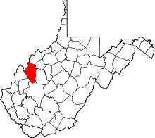 | |
| Unincorporated communities |
| |
| Ghost towns | ||
| Footnotes | ‡This populated place also has portions in an adjacent county or counties | |
This article is issued from
Wikipedia.
The text is licensed under Creative Commons - Attribution - Sharealike.
Additional terms may apply for the media files.