Ketchuptown, South Carolina
| Ketchuptown, South Carolina | |
|---|---|
| Unincorporated Community | |
 Country store at the crossroads | |
 Ketchuptown  Ketchuptown | |
| Coordinates: 34°06′08″N 79°09′19″W / 34.10222°N 79.15528°WCoordinates: 34°06′08″N 79°09′19″W / 34.10222°N 79.15528°W | |
| Country | United States |
| State | South Carolina |
| County | Horry |
| Established | 1920s |
| Time zone | Eastern |
| ZIP Code | 29581 |
| Area code(s) | 843 |
Ketchuptown is a historic unincorporated community located in Horry County, South Carolina, United States. Ketchuptown is at the intersection of Highways 23 and 99 north of Aynor. Ketchuptown is known to be a small homestead and farming community. During the 1920s farmers in the community about ten miles north of Aynor would say to one another, "Lets go catch up on the news." Every Saturday afternoon would find them at a little country store in Ketchuptown. Highway 99 led east to Loris and southwest to Galivants Ferry. Cool Spring was approximately ten miles away on Highway 23.
External links
- Ketchuptown (Horry County Board of Architectural Review)
- "Ketchuptown, 1927-1994; The Place To Catch Up On The News," by Ruth Ham (Horry County Historical Society)
Municipalities and communities of Horry County, South Carolina, United States | ||
|---|---|---|
| Cities | 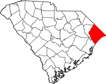 | |
| Towns | ||
| CDPs | ||
| Unincorporated communities | ||
This article is issued from
Wikipedia.
The text is licensed under Creative Commons - Attribution - Sharealike.
Additional terms may apply for the media files.