South Carolina Highway 917
| ||||
|---|---|---|---|---|
 | ||||
| Route information | ||||
| Maintained by SCDOT | ||||
| Length | 36.69 mi[1] (59.05 km) | |||
| Existed | 1940 – present | |||
| Major junctions | ||||
| South end |
| |||
| North end |
| |||
| Location | ||||
| Counties | Horry, Marion, Dillon | |||
| Highway system | ||||
| ||||

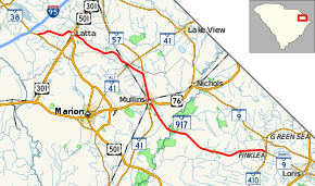
South Carolina Highway 917 (SC 917) is a state highway in the U.S. State of South Carolina that runs from the SC 410/SC 9 Business (SC 9 Bus.) intersection between Green Sea and Loris in Horry County to the SC 38 intersection outside Latta in Dillon County.
Route description
The highway travels in a southeast to northwest direction, but is signed as a north-south highway. It runs just under forty miles (64 km) between SC 410/SC 9 Bus. in the communnity of Finklea, through Mullins where it has a concurrency with SC 41 and intersects US 76, Latta where it intersects U.S. Route 301 (US 301) and US 501, to SC 38 south of its interchange with I-95.[2]
Major intersections
| County | Location | mi[1] | km | Destinations | Notes |
|---|---|---|---|---|---|
| Horry | Finklea | 0.00 | 0.00 | ||
| Marion | Mullins | 18.99 | 30.56 | South end of SC 41 overlap | |
| 19.14 | 30.80 | ||||
| | 23.02 | 37.05 | North end of SC 41 overlap | ||
| Marion–Dillon county line | Smithboro | 25.31 | 40.73 | ||
| Dillon | Latta | 34.46 | 55.46 | ||
| | 39.69 | 63.87 | |||
1.000 mi = 1.609 km; 1.000 km = 0.621 mi
| |||||
References
- 1 2 "Statewide Highways (shapefile)" (zip). South Carolina Department of Transportation. September 29, 2017. Retrieved December 8, 2017.
- ↑ Google (February 25, 2018). "South Carolina Highway 917" (Map). Google Maps. Google. Retrieved February 25, 2018.
External links
Route map:

- South Carolina Hwy Index - SC 917
This article is issued from
Wikipedia.
The text is licensed under Creative Commons - Attribution - Sharealike.
Additional terms may apply for the media files.