Hawaii County, Hawaii
| Hawaii County, Hawaii | ||
|---|---|---|
 | ||
| ||
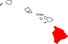 Location in the U.S. state of Hawaii | ||
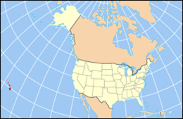 Hawaii's location in the U.S. | ||
| Founded | 1905 | |
| Government • Mayor |
Harry Kim | |
| Seat | Hilo | |
| Largest city | Hilo | |
| Area | ||
| • Total | 5,086.70 sq mi (13,174 km2) | |
| • Land | 4,028.02 sq mi (10,433 km2) | |
| • Water | 1,058.69 sq mi (2,742 km2), ?% | |
| Population (est.) | ||
| • (2016) | 198,449 | |
| • Density | 46/sq mi (17.7/km2) | |
| Congressional district | 2nd | |
| Time zone | Hawaii–Aleutian: UTC−10 | |
| Website |
co | |

Hawaiʻi County is a county in the U.S. state of Hawaii in the Hawaiian Islands. It is coterminous with the Island of Hawaiʻi, often called the "Big Island" to distinguish it from the state as a whole. As of the 2010 Census the population was 185,079. The county seat is Hilo. There are no incorporated cities in Hawaiʻi County (see Hawaii Counties). The Hilo Micropolitan Statistical Area includes all of Hawaiʻi County. Hawaiʻi County has a mayor-council form of government. Hawaii County is the largest county in the state in terms of geography.
The mayor of Hawaii County is Harry Kim, who took office in 2016. Legislative authority is vested in a nine-member Hawaii County Council.
Hawaii County is one of seven counties in the United States to share the same name as the state they are in (the other six are Arkansas County, Idaho County, Iowa County, New York County, Oklahoma County, and Utah County).[1]
Geography
Hawaiʻi County has a total area of 5,086.70 square miles (13,174.5 km2); 4,028.02 square miles (10,432.5 km2) is land and 1,058.69 square miles (2,742.0 km2) is water[2] (mostly all off the ocean shoreline but counted in the total area by the U.S. Census Bureau). The county's land area comprises 62.7 percent of the state's land area. It is the highest percentage by any county in the United States. (Delaware's Sussex County comes in second at 48.0 percent, while Rhode Island's Providence County is third at 39.55 percent.)
Major Highways
Adjacent county
- Maui County - northwest
Demographics
As of 2010, the island had a resident population of 185,079.[3] There were 64,382 households in the county. The population density was 17.7/km² (45.9/mi²). There were 82,324 housing units at an average density of 8/km² (20/mi²). The racial makeup of the county was 34.5% White, 0.7% African American, 22.6% Asian, 12.4% Native Hawaiian or other Pacific Islander, and 29.2% from two or more races; 11.8% of the population were Hispanics or Latinos of any race. The largest ancestry groups were:
- 9.8% Japanese
- 9.6% German
- 8.6% Filipino
- 8.5% Native Hawaiian
- 8.3% Portuguese
- 6.9% Irish
- 5.7% English
- 5.1% Puerto Rican
- 3.2% Mexican
- 2.5% French
- 2.2% Italian
- 1.9% Spanish
- 1.7% Scottish
- 1.5% Scotch-Irish
- 1.5% Swedish
- 1.1% Polish
- 1.1% Dutch
- 1.0% Norwegian
Government and infrastructure
| Year | Republican | Democratic | Others |
|---|---|---|---|
| 2016 | 26.98% 17,501 | 63.61% 41,259 | 9.41% 6,107 |
| 2012 | 23.25% 14,753 | 74.42% 47,224 | 2.33% 1,477 |
| 2008 | 22.22% 14,866 | 75.94% 50,819 | 1.84% 1,231 |
| 2004 | 38.18% 22,032 | 60.86% 35,116 | 0.96% 554 |
| 2000 | 33.52% 17,050 | 56.37% 28,670 | 10.10% 5,140 |
| 1996 | 27.60% 13,516 | 55.66% 27,262 | 16.74% 8,199 |
| 1992 | 30.36% 15,460 | 50.52% 25,725 | 19.11% 9,731 |
| 1988 | 41.00% 17,125 | 57.68% 24,091 | 1.32% 552 |
| 1984 | 52.90% 20,707 | 45.64% 17,866 | 1.46% 570 |
| 1980 | 39.73% 14,247 | 49.16% 17,630 | 11.11% 3,984 |
| 1976 | 48.37% 15,366 | 50.24% 15,960 | 1.38% 439 |
| 1972 | 59.09% 16,832 | 40.91% 11,652 | |
| 1968 | 37.41% 9,625 | 61.49% 15,819 | 1.10% 283 |
| 1964 | 19.87% 4,962 | 80.13% 20,011 | |
| 1960 | 51.46% 12,251 | 48.54% 11,557 |
County government
Executive authority is vested in the mayor of Hawaii County, who is elected for a four-year term. Since 2004, the election by the voters has been on a nonpartisan basis. In 2016, Harry Kim was elected mayor, succeeding Billy Kenoi, who had served a two-term limit.[5] Legislative authority is vested in a nine-member County Council. Each member represents a geographical region of the island, which closely correlates to one of the nine tax map districts of Hawaiʻi County. Members of the County Council are elected on a nonpartisan basis to two-year terms, with the latest election occurring in November 2016. As of December 2016, Hawaii County Council has a female supermajority for the first time, with six women and three men.[6]
Administrative districts were originally based on the traditional land divisions called Moku of Ancient Hawaii. Some more heavily populated districts have since been split into North and South districts to make them more comparable on a population basis.
The number following each district is the Tax Map Key (TMK) number, used to locate state property information. They are assigned in a counter-clockwise order beginning on the eastern side of the island.[7]
| Nr. | District | Area mi² | Population 2000 | moku | Map |
|---|---|---|---|---|---|
| 1 | Puna | 499.45 | 31335 | Puna | 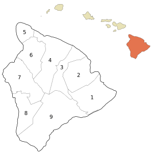 |
| 2 | South Hilo | 394.38 | 47386 | Hilo | |
| 3 | North Hilo | 370.65 | 1720 | Hilo | |
| 4 | Hamakua | 580.50 | 6108 | Hāmākua | |
| 5 | North Kohala | 132.92 | 6038 | Kohala | |
| 6 | South Kohala | 351.72 | 13131 | Kohala | |
| 7 | North Kona | 489.01 | 28543 | Kona | |
| 8 | South Kona | 335.38 | 8589 | Kona | |
| 9 | Kaʻū | 922.22 | 5827 | Kaʻū | |
| Hawaiʻi County | 4028.02 | 148677 | 6 moku |
County council districts do not directly match the property tax districts because of the variation in the population density of voters in urban areas to rural areas; Hilo & Kailua (Kailua-Kona) towns are densely populated areas, while other districts such as Kaʻū, Puna, Hāmakua, and North & South Kohala are more sparsely populated.[8]
Several government functions are administered at the county level that are at the state or municipal level in other states. For example, the county has its own office of liquor control.[9]
State government
Hawaii Department of Public Safety previously operated the Kulani Correctional Facility in Hawaii County, on the Island of Hawaii.[10] In 2009, the Hawaii Department of Public Safety announced that Kulani Correctional Facility would close.[11]
Localities
| Historical population | |||
|---|---|---|---|
| Census | Pop. | %± | |
| 1900 | 46,843 | — | |
| 1910 | 55,382 | 18.2% | |
| 1920 | 64,895 | 17.2% | |
| 1930 | 73,325 | 13.0% | |
| 1940 | 73,276 | −0.1% | |
| 1950 | 68,350 | −6.7% | |
| 1960 | 61,332 | −10.3% | |
| 1970 | 63,468 | 3.5% | |
| 1980 | 92,053 | 45.0% | |
| 1990 | 120,317 | 30.7% | |
| 2000 | 148,677 | 23.6% | |
| 2010 | 185,079 | 24.5% | |
| Est. 2016 | 198,449 | [12] | 7.2% |
| U.S. Decennial Census[13] Historical Population 1900-90[14] | |||
Census-designated places
- Ainaloa
- Captain Cook
- Eden Roc
- Fern Acres
- Fern Forest
- Halaula
- Hawaiian Acres
- Hawaiian Beaches
- Hawaiian Ocean View
- Hawaiian Paradise Park
- Hawi
- Hilo
- Holualoa
- Honalo
- Honaunau-Napoopoo
- Honokaa
- Honomu
- Kahaluu-Keauhou
- Kailua
- Kalaoa
- Kapaau
- Keaau
- Kealakekua
- Keokea
- Kukuihaele
- Kurtistown
- Laupahoehoe
- Leilani Estates
- Mountain View
- Naalehu
- Nanawale Estates
- Orchidlands Estates
- Paauilo
- Pahala
- Pahoa
- Papaikou
- Pepeekeo
- Paukaa
- Puako
- Volcano
- Waikoloa Village
- Waimea
- Wainaku
- Waiohinu
Other communities
National protected areas
Economy
Top employers
According to the County's 2010 Comprehensive Annual Financial Report,[15] the top employers in the county are:
| # | Employer | # of Employees |
|---|---|---|
| 1 | State of Hawaii | 8,115 |
| 2 | Hawaii County | 2,745 |
| 3 | United States Government | 1,364 |
| 4 | Hilton Waikoloa Village | 984 |
| 5 | Wal-Mart | 852 |
| 6 | KTA Super Stores | 800 |
| 7 | Mauna Kea Beach Hotel | 685 |
| 8 | The Fairmont Orchid | 577 |
| 9 | Four Seasons Resort Hualalai | 562 |
| 10 | Hapuna Beach Prince Hotel | 487 |
Sister cities
Hawaii County has 10 sisters:[16]


References
- ↑ Joseph Nathan Kane; Charles Curry Aiken (2005). The American Counties: Origins of County Names, Dates of Creation, and Population Data, 1950-2000. Scarecrow Press. ISBN 978-0-8108-5036-1.
- ↑ "Census 2000 U.S. Gazetteer Files: Counties". United States Census. Archived from the original on 2011-05-12. Retrieved 2011-02-13.
- ↑ "Archived copy". Archived from the original on 2011-07-11. Retrieved 2014-06-28.
- ↑ Leip, David. "Dave Leip's Atlas of U.S. Presidential Elections". uselectionatlas.org. Retrieved May 26, 2017.
- ↑ "Office of the Mayor". official web site. County of Hawaii. Archived from the original on 2011-07-08. Retrieved 2010-03-27.
- ↑
- ↑ Hawaii County: 2000
- ↑ "Hawaiʻi County Council". official web site. Archived from the original on 2011-07-08. Retrieved 2010-03-27.
- ↑ "Office of Liquor Control". Hawaii County web site. Archived from the original on November 23, 2010. Retrieved December 25, 2010.
- ↑ "Kulani Correctional Facility." Hawaii Department of Public Safety. Retrieved on September 30, 2010.
- ↑ "Closure of Kulani Saves $2.8M Annually; Facility to Help At-Risk Youth." Hawaii Department of Public Safety. July 2009. Retrieved on September 30, 2010.
- ↑ "Population and Housing Unit Estimates". Retrieved June 9, 2017.
- ↑ U.S. Decennial Census
- ↑ Hawaii Historical Population 1900-1990
- ↑ County of Hawaii CAFR Archived 2011-09-29 at the Wayback Machine.
- ↑ State of Hawaii’s Sister States/Cities A Report to the Hawaii State Legislature 2006
- ↑ "Hula and economy bind Hawaii, Shibukawa sister cities". Big Island Video News. Retrieved 2015-05-02.
External links
| Wikimedia Commons has media related to Hawaii County, Hawaii. |
- Official Hawaii County website
- Volcanoes National Park
- Economic background from the Revision of the Hawaii County General Plan

Coordinates: 19°35′N 155°30′W / 19.583°N 155.500°W
Honolulu (capital) | ||
| Topics | ||
| Society | ||
| Main islands | ||
| Northwestern Islands | ||
| Communities | ||
| Counties | ||
| Sovereignty Movement | ||