Kalaoa, Hawaii
| Kalaoa, Hawaii | |
|---|---|
| Census-designated place | |
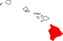
 Location in Hawaii County and the state of Hawaii | |
| Coordinates: 19°43′23″N 156°0′17″W / 19.72306°N 156.00472°WCoordinates: 19°43′23″N 156°0′17″W / 19.72306°N 156.00472°W | |
| Country | United States |
| State | Hawaii |
| County | Hawaii |
| Area | |
| • Total | 45.6 sq mi (118.1 km2) |
| • Land | 39.2 sq mi (101.4 km2) |
| • Water | 6.4 sq mi (16.7 km2) |
| Elevation | 680 ft (210 m) |
| Population (2010) | |
| • Total | 9,644 |
| • Density | 246/sq mi (95.1/km2) |
| Time zone | UTC-10 (Hawaii-Aleutian) |
| Area code(s) | 808 |
| FIPS code | 15-25400 |
| GNIS feature ID | 2414061 |
Kalaoa is a census-designated place (CDP) in Hawaiʻi County, Hawaiʻi, United States. The population was 9,644 as of the 2010 census,[1] up from 6,794 residents at the 2000 census.
Geography
Kalaoa is located on the west side of the island of Hawaii at 19°43′23″N 156°0′17″W / 19.72306°N 156.00472°W (19.722969, -156.004669).[2] It is bordered to the south by Kailua-Kona, and Waimea is 33 miles (53 km) to the northeast. Kalaoa sits on the lower western slopes of the Hualalai volcano and extends west to the Pacific Ocean.
According to the United States Census Bureau, the CDP has a total area of 45.6 square miles (118.1 km2), of which 39.2 square miles (101.4 km2) are land and 6.4 square miles (16.7 km2), or 14.13%, are water.[1]
Demographics
2000 Census data
| Historical population | |||
|---|---|---|---|
| Census | Pop. | %± | |
| 1990 | 4,490 | — | |
| 2000 | 6,794 | 51.3% | |
| 2010 | 9,644 | 41.9% | |
| source:[3] | |||
As of the census[4] of 2000, there were 6,794 people, 2,402 households, and 1,724 families residing in the CDP. The population density was 172.1 people per square mile (66.4/km²). There were 2,541 housing units at an average density of 64.4 per square mile (24.9/km²). The racial makeup of the CDP was 49.34% White, 0.35% African American, 0.52% Native American, 13.39% Asian, 10.35% Pacific Islander, 0.78% from other races, and 25.27% from two or more races. Hispanic or Latino of any race were 5.95% of the population.
There were 2,402 households out of which 34.6% had children under the age of 18 living with them, 57.8% were married couples living together, 9.7% had a female householder with no husband present, and 28.2% were non-families. 19.4% of all households were made up of individuals and 3.7% had someone living alone who was 65 years of age or older. The average household size was 2.83 and the average family size was 3.19.
In the CDP the population was spread out with 25.5% under the age of 18, 6.8% from 18 to 24, 29.5% from 25 to 44, 29.3% from 45 to 64, and 8.9% who were 65 years of age or older. The median age was 39 years. For every 100 females, there were 102.5 males. For every 100 females age 18 and over, there were 101.2 males.
The median income for a household in the CDP was $53,024, and the median income for a family was $56,461. Males had a median income of $35,082 versus $27,130 for females. The per capita income for the CDP was $24,179. About 3.0% of families and 6.2% of the population were below the poverty line, including 7.2% of those under age 18 and 5.1% of those age 65 or over.
Economy
Mokulele Airlines, a small inter-island commuter airline, is headquartered in the CDP, on the grounds of Keahole at Kona Int'l Airport.[5][6]
Transportation
Keahole at Kona International Airport is located in the lower Kalaoa CDP, and serves the western side of the Big Island, including Kailua-Kona, Holualoa, Keauhou, Captain Cook, Waikoloa, Waimea, and the Kohala Coast. The Kalaoa area is served by two major highways: the upper and lower routes of Hawaii Belt Road. The upper section is known as Mamalahoa Highway/Route 190, and the lower, more utilized coastal route, is known as Queen Ka'ahumanu Highway, but it is also known by its nickname as The Queen K/Route 19.
Points of interest
References
- 1 2 "Geographic Identifiers: 2010 Demographic Profile Data (G001): Kalaoa CDP, Hawaii". American Factfinder. U.S. Census Bureau. Retrieved May 30, 2017.
- ↑ "US Gazetteer files: 2010, 2000, and 1990". United States Census Bureau. 2011-02-12. Retrieved 2011-04-23.
- ↑ "CENSUS OF POPULATION AND HOUSING (1790-2000)". U.S. Census Bureau. Retrieved 2010-07-31.
- ↑ "American FactFinder". United States Census Bureau. Retrieved 2008-01-31.
- ↑ "Contact Us Archived 2009-02-28 at the Wayback Machine.." Mokulele Airlines. Retrieved on May 21, 2009.
- ↑ "Kalaoa CDP, Hawaii." U.S. Census Bureau. Retrieved on May 21, 2009.