Mountain View, Hawaii
| Mountain View, Hawaii | |
|---|---|
| Census-designated place | |
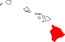
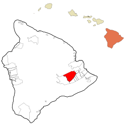 Location in Hawaii County and the state of Hawaii | |
| Coordinates: 19°32′23″N 155°8′29″W / 19.53972°N 155.14139°WCoordinates: 19°32′23″N 155°8′29″W / 19.53972°N 155.14139°W | |
| Country | United States |
| State | Hawaii |
| County | Hawaii |
| Area | |
| • Total | 55.8 sq mi (144.4 km2) |
| • Land | 55.8 sq mi (144.4 km2) |
| • Water | 0.0 sq mi (0.0 km2) |
| Elevation | 1,434 ft (437 m) |
| Population (2010) | |
| • Total | 3,924 |
| • Density | 70/sq mi (27.2/km2) |
| Time zone | UTC-10 (Hawaii-Aleutian) |
| ZIP code | 96771 |
| Area code(s) | 808 |
| FIPS code | 15-53300 |
| GNIS feature ID | 0362495 |
Mountain View is a census-designated place (CDP) in Hawaiʻi County, Hawaiʻi, United States located in the District of Puna. The population was 3,924 at the 2010 census,[1] up from 2,799 at the 2000 census.
Geography
Mountain View is located on the east side of the island of Hawaii, also known as the Big Isand, at 19°32′23″N 155°8′29″W / 19.53972°N 155.14139°W (19.539730, -155.141348).[2] It is bordered by Kurtistown to the northeast, Hawaiian Acres to the east, Fern Acres and Eden Roc to the southeast, Fern Forest to the south, and Volcano to the southwest. Hawaii Route 11 runs through the southeast side of the community, leading north 15 miles (24 km) to Hilo and southwest 15 miles to Hawaii Volcanoes National Park.
According to the United States Census Bureau, the CDP has a total area of 55.8 square miles (144.4 km2), all of it land.[1]
Climate
| Climate data for Mountain View | |||||||||||||
|---|---|---|---|---|---|---|---|---|---|---|---|---|---|
| Month | Jan | Feb | Mar | Apr | May | Jun | Jul | Aug | Sep | Oct | Nov | Dec | Year |
| Record high °F (°C) | 87 (31) |
86 (30) |
85 (29) |
83 (28) |
84 (29) |
90 (32) |
85 (29) |
88 (31) |
87 (31) |
87 (31) |
84 (29) |
87 (31) |
90 (32) |
| Average high °F (°C) | 74.8 (23.8) |
74.1 (23.4) |
73.4 (23) |
73.8 (23.2) |
75 (24) |
76.9 (24.9) |
77.2 (25.1) |
78.1 (25.6) |
78.7 (25.9) |
78.2 (25.7) |
76 (24) |
74.5 (23.6) |
75.9 (24.4) |
| Daily mean °F (°C) | 65.8 (18.8) |
65.4 (18.6) |
65.3 (18.5) |
66.1 (18.9) |
67.2 (19.6) |
68.7 (20.4) |
69.4 (20.8) |
70.1 (21.2) |
70 (21) |
69.6 (20.9) |
68 (20) |
66.3 (19.1) |
67.7 (19.8) |
| Average low °F (°C) | 56.8 (13.8) |
56.6 (13.7) |
57.2 (14) |
58.4 (14.7) |
59.3 (15.2) |
60.5 (15.8) |
61.6 (16.4) |
62.1 (16.7) |
61.3 (16.3) |
60.9 (16.1) |
59.9 (15.5) |
58 (14) |
59.4 (15.2) |
| Record low °F (°C) | 43 (6) |
38 (3) |
45 (7) |
47 (8) |
49 (9) |
49 (9) |
52 (11) |
52 (11) |
51 (11) |
48 (9) |
47 (8) |
42 (6) |
38 (3) |
| Average rainfall inches (mm) | 12.69 (322.3) |
16.99 (431.5) |
20.88 (530.4) |
21.14 (537) |
15.62 (396.7) |
9.69 (246.1) |
12.88 (327.2) |
15.29 (388.4) |
9.92 (252) |
12.84 (326.1) |
19.79 (502.7) |
17.87 (453.9) |
185.6 (4,714.3) |
| Average precipitation days | 19 | 20 | 25 | 26 | 27 | 25 | 27 | 27 | 23 | 24 | 23 | 23 | 289 |
| Source: WRCC | |||||||||||||
Demographics
As of the census of 2010, there were 3,924 people in 1,318 households residing in the CDP. The population density was 69.3 people per square mile (26.7/km²). There were 1,510 housing units at an average density of 26.7 per square mile (10.3/km²). The racial makeup of the CDP was 24.90% White, 0.38% African American, 0.71% American Indian & Alaska Native, 16.00% Asian, 9.89% Native Hawaiian & Pacific Islander, 1.68% from other races, 46.43% from two or more races. Hispanic or Latino of any race were 20.41% of the population.[3]
There were 1,318 households out of which 34.6% had children under the age of 18 living with them. The average household size was 2.98.[3]
In the Mountain View CDP the population was spread out with 29.6% under the age of 18, 8.8% from 18 to 24, 12.4% from 25 to 34, 18.0 from 35 to 49, 21.5% from 50 to 64, and 9.7% who were 65 years of age or older. For every 100 females, there were 96.9 males. For every 100 males there were 103.2 females.[3]
The median income for a household in the CDP at the 2000 census was $26,860, and the median income in 2000 for a family was $33,750. Males had a median income in 2000 of $24,250 versus $22,135 for females. The per capita income for the CDP in 2000 was $13,229. About 23.6% of families and 30.3% of the population were below the poverty line in 2000, including 45.7% of those under age 18 and 5.0% of those age 65 or over.
References
- 1 2 "Geographic Identifiers: 2010 Demographic Profile Data (G001): Mountain View CDP, Hawaii". American Factfinder. U.S. Census Bureau. Retrieved June 1, 2017.
- ↑ "US Gazetteer files: 2010, 2000, and 1990". United States Census Bureau. 2011-02-12. Retrieved 2011-04-23.
- 1 2 3 US Census Bureau - 2010 Population Finder - Mountain View CDP -