French Frigate Shoals
Coordinates: 23°44′56″N 166°8′46″W / 23.74889°N 166.14611°W
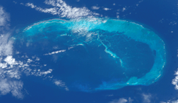
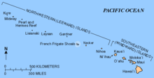
The French Frigate Shoals (Hawaiian: Kānemilohaʻi) is the largest atoll in the Northwestern Hawaiian Islands. Its name commemorates French explorer Jean-François de La Pérouse, who nearly lost two frigates when attempting to navigate the shoals. It consists of a 20-mile (32 km) long crescent-shaped reef, twelve sandbars, and the 120-foot (37 m) high La Perouse Pinnacle, the only remnant of its volcanic origins. The total land area of the islets is 61.508 acres (24.891 ha). Total coral reef area of the shoals is over 232,000 acres (94,000 ha). Tern Island, with an area of 26.014 acres (10.527 ha), has a landing strip and permanent habitations for a small number of people. It is maintained as a field station in the Hawaiian Islands National Wildlife Refuge by the United States Fish and Wildlife Service. The French Frigate Shoals are about 487 nautical miles (902 km; 560 mi) northwest of Honolulu.
History
Although there is no evidence of extensive human activity or presence in the area, the earliest human visitors to the French Frigate Shoals probably came from the main Hawaiian Islands, which were settled by Polynesians between 1100 and 1300 AD.[1]
The Hawaiian island chain lay outside the routes followed by early European explorers, and it was not until La Pérouse's near-disastrous discovery that the shoals were known to the outside world. La Pérouse, aboard the frigate Boussole, was sailing westward from Monterey en route to Macau. During the night of 6 November 1786, sailors sighted breakers directly in their path, about a thousand feet ahead. Both the Boussole and her companion vessel, the frigate Astrolabe, were immediately brought about, passing within a few hundred feet of the breakers. At daybreak, the ships returned and mapped the southeastern half of the atoll, as well as finding the rock that would later be named after La Pérouse. La Pérouse named the shoals Basse des Frégates Françaises, the "Shoal of the French Frigates".[1]
During the late 19th century, American and European companies became interested in the possibility of mining guano in the Hawaiian Islands. U.S. Navy Lieutenant John M. Brooke, sailing on the naval schooner USS Fenimore Cooper, formally took possession of French Frigate Shoals for the United States on 14 January 1859, in accordance with the Guano Islands Act. In 1894, French Frigate Shoals, Kure Atoll, Midway Atoll, and Pearl and Hermes Reef were leased for 25 years by the Republic of Hawaii to the North Pacific Phosphate and Fertilizer Company; however, guano and phosphate deposits at French Frigate Shoals were found to be impractical to mine. The Republic did not formally claim possession of the shoals until 13 July 1895.[1]
French Frigate Shoals was included among the islands acquired by the United States on 7 July 1898, when Hawaii became a United States territory. In 1909 it was made a part of the Hawaiian Islands Bird Reservation.
World War II; U.S. Coast Guard LORAN
In March 1942, Japanese naval planners took advantage of the shoal's isolation to use its protected waters as an anchorage and refueling point for the long-range flying boats employed in their Operation K. In the aftermath of that attack, US Pacific Fleet Commander Chester W. Nimitz ordered a permanent US Navy presence at the shoals.[2]
After the Battle of Midway, the United States Navy built a naval air station on Tern Island, enlarging the island sufficiently to support a 3,300-foot (1,000 m) landing strip; Tern Island now has a land area of 26.014 acres (10.527 ha). The station's main function was as an emergency landing site for planes flying between Hawaii and Midway Atoll. French Frigate Shoals Airport comprises what remains of the original seawall, coral/rock/gravel runway, and buildings.[3]
The United States Coast Guard operated a LORAN aids to navigation station on East Island until 1952, and Tern Island until 1979. At any one time, 15 to 20 military personnel were billeted to French Frigate Shoals. The LORAN station was staffed with USCG enlisted specialists such as Radioman, Electronic Technician, Fireman, Boatswain's Mates, other military occupational ratings. The commanding officer was typically a Lieutenant Junior Grade officer, the executive officer a chief petty officer enlisted rank. The Coast Guard designated the French Frigate Shoals billet as "isolated duty." Because of the billet's remoteness, a duty term was limited to one year. Various USCG members have proudly documented their time on the station.
In 1969 a tsunami devastated the islands.[4]
The United States Fish and Wildlife Service continues to maintain a permanent field station there.[5] In 2000, the atoll became part of the Northwestern Hawaiian Islands Coral Reef Ecosystem Reserve, which was incorporated into the Northwestern Hawaiian Islands National Monument in 2006. In 2009 the islands were evacuated during the approach of Hurricane Neki by landing a USCG C-130 on Tern's coral airstrip.[6]
Geology and ecology
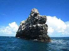
La Perouse Pinnacle, a rock outcrop in the center of the atoll, is the oldest and most remote volcanic rock in the Hawaiian chain. La Perouse Pinnacle stands 120 feet (37 m) tall and is surrounded by coral reefs. Because of its peculiar shape, the pinnacle is often mistaken for a ship from a distance.[7][8]
Whale-Skate Island is a submerged island in the French Frigate Shoals. These islands suffered considerably from erosion starting in the 1960s, and by the late 1990s, Whale-Skate Island was completely washed over.[9]
The reef system at French Frigate Shoals supports 41 species of stony corals, including several species that are not found in the main Hawaiian Island chain. More than 600 species of marine invertebrates, many of which are endemic, are found there as well.[10]
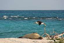
More than 150 species of algae live among the reefs. Especially diverse algal communities are found immediately adjacent to La Perouse Pinnacle. This has led to speculation that an influx of additional nutrients – in the form of guano – is responsible for the diversity and productivity of algae in this environment.[10] The reef waters support large numbers of fish. The masked angelfish (Genicanthus personatus), endemic to the Hawaiian Islands, is relatively common there. Most of Hawaii's honu (green sea turtles) travel to the shoals to nest. The small islets of French Frigate Shoals provide refuge to the largest surviving population of Hawaiian monk seals, the second most endangered pinniped in the world.[5]
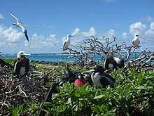
The islands are also an important seabird colony. Eighteen species of seabird, the black-footed albatross, Laysan albatross, Bonin petrel, Bulwer's petrel, wedge-tailed shearwater, Christmas shearwater, Tristram's storm-petrel, red-tailed tropicbird, masked booby, red-footed booby, brown booby, great frigatebird, spectacled tern, sooty tern, blue-gray noddy, brown noddy, black noddy and white tern nest on the islands, most of them (16) on Tern Island. Two species, the blue-gray noddy and the brown booby, nest only on La Perouse Pinnacle. The island also is the wintering ground for several species of shorebird.[11][12]
A three-week research mission in October 2006 by the National Oceanic and Atmospheric Administration (NOAA) led to the discovery of 100 species never seen in the area before, including many that are totally new to science. The research findings could be used to establish what species live in the area and to determine how well the shoals' ecosystem is being managed and the threats it faces. The French Frigate Shoals project is part of the Census of Coral Reef Ecosystems of the International Census of Marine Life.[13]
Islands
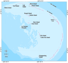
Listing of FFS islands:
| Island | Census- block | Area m2 | Coordinates |
|---|---|---|---|
| Shark Island | 1010 | 4294 | 23°51′09.9″N 166°19′26.3″W / 23.852750°N 166.323972°W |
| Tern Island | 1009 | 105276 | |
| Trig Island | 1008 | 23298 | |
| Skate Island 1) | 1007 | 12808 | |
| Whale Island 1) | 1007 | 19212 | |
| Disappearing Island | 1002 | 9800 | |
| Little Gin Island | 1003 | 19448 | |
| Gin Island | 1004 | 9708 | |
| Near Island 2) | - | 400 | 23°48′20″N 166°13′46″W / 23.80556°N 166.22944°W |
| Bare Island 3) | - | 400 | |
| East Island | 1005 | 35853 | |
| Mullet Island 4) | 1006 | 2462 | |
| Round Island 4) | 1006 | 3078 | |
| La Perouse Pinnacle | 1011 | 3677 | |
1) Whale-Skate Island, currently a double island, is also listed in the census documents together as a block, with an area of 32,020 m². The shares of the islands are estimated (40 and 60 percent).
2) 1971 it was reported that Near Island, although recorded on maps, would be submerged at high tide.
3) Bare Island can be seen on satellite images but[14] is not listed in the Census Tract.[15] A 1971 publication says Bare Island has an area of 0.1 acres (about 400 m2).[16]
4) Round and Mullet Islands in census documents found together as a block 1006, together with an area of 5540 m2. The shares are valued according to a report from 1971 (0.4 and 0.5 acres).
See also
References
- 1 2 3 Marts, Chris. "Tern Island: History". college.wfu.edu. Retrieved 2018-08-10.
- ↑ 1962-, Parshall, Jonathan B., (2005). Shattered sword : the untold story of the Battle of Midway. Tully, Anthony P., 1961-. Washington, D.C.: Potomac Books. ISBN 1574889230. OCLC 60373935.
- ↑ "Abandoned & Little-Known Airfields: Western Pacific Islands". www.airfields-freeman.com. Retrieved 2018-08-10.
- ↑ "LORAN STATION FRENCH FRIGATE SHO". www.loran-history.info. Retrieved 2018-08-10.
- 1 2 Scott, Susan (June 3, 2004). "Tern Island: Noah's ark of the Hawaiian Islands. Part 1: Beauty more than guano deep". archives.starbulletin.com. Retrieved 2018-08-10.
- ↑ "U.S. Coast Guard aircrew rescues 10 from French Frigate Shoals". CoastGuardNews.com. 22 October 2009. Retrieved 29 March 2017.
- ↑ Rauzon, Mark (2001). Isles of Refuge: Wildlife and History of the Northwestern Hawaiian Islands. University of Hawaii Press. p. 55. ISBN 0-8248-2330-3.
- ↑ "NWHI: About: French Frigate Shoals". Northwestern Hawaiian Islands Multi-Agency Education Project. Retrieved October 9, 2016.
- ↑ George., Philander, Dr. (2008). Encyclopedia of Global Warming and Climate Change. Thousand Oaks: SAGE Publications. ISBN 9781452265889. OCLC 815786021.
- 1 2 "French Frigate Shoals (Kānemiloha'i)". www.papahanaumokuakea.gov. Retrieved 2018-08-10.
- ↑ HATFIELD, JEFF S.; REYNOLDS, MICHELLE H.; SEAVY, NATHANIEL E.; KRAUSE, CRYSTAL M. (2012-05-24). "Population Dynamics of Hawaiian Seabird Colonies Vulnerable to Sea-Level Rise". Conservation Biology. 26 (4): 667–678. doi:10.1111/j.1523-1739.2012.01853.x. ISSN 0888-8892.
- ↑ "TECHNICAL SUPPORT DOCUMENT TO THE PRELIMINARY ASSESSMENT OF THE FWS – HAWAIIAN ISLANDS NATIONAL WILDLIFE REFUGE: TERN ISLAND SITE IN THE FRENCH FRIGATE SHOALS, HAWAIʻI" (PDF). September 2014.
- ↑ "New Species and New Records of Marine Species Discovered in the Northwestern Hawaiian Islands Marine National Monument". ucsdnews.ucsd.edu. Retrieved 2018-08-10.
- ↑ # lat = 23.792563 & lon = -166.2015957 & z = 19 & l = 5 & m = b Bare in Iceland satellite image. Here, the length and width of about 25 meters and 6 are measured, or in an area of approximately 150 m².
- ↑ PDF bei www.statecountymaps.com Archived 22 June 2015 at the Wayback Machine.
- ↑ A. Binion Amerson jr.: The Natural History of French Frigate Shoals, Northwestern Hawaiian Islands. Atoll Research Bulletin No. 150, 1971, Seite 28: Bare Island ... is awash at high tide and is usually about 100 feet long, 10 feet wide, and 4 feet high. It covers an area of 0.1 acre. Wetmore (ms.) in 1923 described it as "60 yards long by 10 wide, merely a ridge of sand rising 5 feet above the water and evidently swept" by waves.
External links
| Wikimedia Commons has media related to French Frigate Shoals. |
- The French Frigate Shoals Web Page
- Quick Facts on French Frigate Shoals from the PBS Ocean Adventures site
| |||||||||||||||
| Authority control |
|---|