Papaikou, Hawaii
| Papaikou, Hawaii | |
|---|---|
| Census-designated place | |
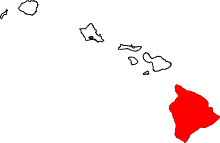
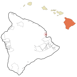 Location in Hawaii County and the state of Hawaii | |
| Coordinates: 19°47′38″N 155°5′48″W / 19.79389°N 155.09667°WCoordinates: 19°47′38″N 155°5′48″W / 19.79389°N 155.09667°W | |
| Country | United States |
| State | Hawaii |
| County | Hawaii |
| Area | |
| • Total | 1.88 sq mi (4.86 km2) |
| • Land | 1.44 sq mi (3.74 km2) |
| • Water | 0.43 sq mi (1.12 km2) |
| Elevation | 236 ft (72 m) |
| Population (2010) | |
| • Total | 1,314 |
| • Density | 909/sq mi (351.1/km2) |
| Time zone | UTC-10 (Hawaii-Aleutian) |
| ZIP code | 96781 |
| Area code(s) | 808 |
| FIPS code | 15-61550 |
| GNIS feature ID | 0363121 |
Papaikou is a census-designated place (CDP) in Hawaii County, Hawaii, United States, and is a few miles north of the county seat, Hilo. The population of Papaikou was 1,314 at the 2010 census,[1] down from 1,414 at the 2000 census.
Geography
Papaikou is located on the east side of the island of Hawaii at 19°47′38″N 155°5′48″W / 19.79389°N 155.09667°W (19.794022, -155.096531).[2] Hawaii Route 19 passes through the community, leading south 5 miles (8 km) to Hilo and northwest 37 miles (60 km) to Honokaa.
According to the United States Census Bureau, the Papaikou CDP has a total area of 1.9 square miles (4.9 km2), of which 1.4 square miles (3.7 km2) are land and 0.42 square miles (1.1 km2), or 23.03%, are water.[1] The CDP borders the Pacific Ocean from Hokeo Point in the north to Kekiwi Point in the south.
Demographics
As of the census[3] of 2000, there were 1,414 people, 475 households, and 363 families residing in the CDP. The population density was 964.3 people per square mile (371.4/km2). There were 502 housing units at an average density of 342.4 per square mile (131.9/km2). The racial makeup of the CDP was 15.28% White, 0.50% African American, 0.07% Native American, 45.83% Asian, 9.41% Pacific Islander, 1.41% from other races, and 27.51% from two or more races. Hispanic or Latino of any race were 6.86% of the population.
There were 475 households out of which 29.5% had children under the age of 18 living with them, 52.8% were married couples living together, 14.7% had a female householder with no husband present, and 23.4% were non-families. 19.4% of all households were made up of individuals and 10.7% had someone living alone who was 65 years of age or older. The average household size was 2.98 and the average family size was 3.35.
In the CDP the population was spread out with 24.2% under the age of 18, 7.8% from 18 to 24, 24.8% from 25 to 44, 23.2% from 45 to 64, and 20.1% who were 65 years of age or older. The median age was 40 years. For every 100 females, there were 97.2 males. For every 100 females age 18 and over, there were 96.3 males.
The median income for a household in the CDP was $37,031, and the median income for a family was $40,446. Males had a median income of $25,000 versus $24,205 for females. The per capita income for the CDP was $13,782. About 12.1% of families and 15.0% of the population were below the poverty line, including 18.0% of those under age 18 and 7.6% of those age 65 or over.
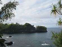
Points of interest
References
- 1 2 "Geographic Identifiers: 2010 Demographic Profile Data (G001): Papaikou CDP, Hawaii". American Factfinder. U.S. Census Bureau. Retrieved June 2, 2017.
- ↑ "US Gazetteer files: 2010, 2000, and 1990". United States Census Bureau. 2011-02-12. Retrieved 2011-04-23.
- ↑ "American FactFinder". United States Census Bureau. Retrieved 2008-01-31.