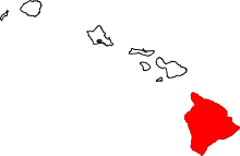
Kailua, Hawaii County, Hawaii
| Kailua-Kona, Hawaii Kailua (Hawaii County) | |
|---|---|
| Census Designated Place | |
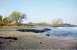
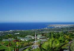 Kailua-Kona from Holualoa | |
 Kailua-Kona | |
| Coordinates: 19°39′0″N 155°59′39″W / 19.65000°N 155.99417°WCoordinates: 19°39′0″N 155°59′39″W / 19.65000°N 155.99417°W | |
| Area | |
| • Total | 39.9 sq mi (103.3 km2) |
| • Land | 35.6 sq mi (92.3 km2) |
| • Water | 4.2 sq mi (11.0 km2) |
| Elevation | 7 ft (2 m) |
| Population (2010) | |
| • Total | 11,975 |
| • Density | 336/sq mi (129.8/km2) |
| Time zone | UTC−10 (Hawaii–Aleutian) |
| ZIP code | 96740 |
| Area code(s) | 808 |
| FIPS code | 15-23000 |
| GNIS feature ID | 365355 |
Kailua is an unincorporated city (Census Designated Place) in Hawaiʻi County, Hawaii, United States, in the North Kona District of the Island of Hawaiʻi.[1] The population was 11,975 at the 2010 census,[2] up from 9,870 at the 2000 census. It is the center of commerce and of the tourist industry on West Hawaiʻi. Its post office is designated Kailua-Kona[3] to differentiate it from Kailua located on the windward side of Oʻahu island, and it is sometimes referred to as Kona in everyday speech. The city is served by Kona International Airport, located just to the north in the adjacent Kalaoa CDP.[4] Kailua-Kona was the closest major settlement to the epicenter of the 2006 Kiholo Bay earthquake.
History
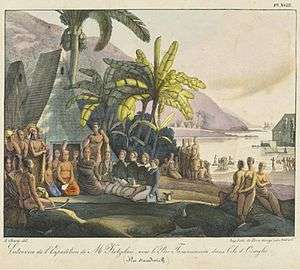
The community was established by King Kamehameha I to be his seat of government when he was chief of Kona before he consolidated rule of the archipelago in 1795. It was later designated as the capital of the newly unified Kingdom of Hawaiʻi. The capital was later moved to Lāhainā, and then to Honolulu.
Royal fishponds at Kaloko-Honokōhau National Historical Park were the hub of unified Hawaiian culture. The town later functioned as a retreat of the Hawaiian royal family. Up until the late 1900s, Kailua-Kona was primarily a small fishing village.[5]:58 In the late 20th and early 21st centuries, the region has undergone a real estate and construction boom fueled by tourism and investment.
Geography
Kailua is located at 19°39′0″N 155°59′39″W / 19.65000°N 155.99417°W (19.649973, −155.994028),[6] along the shoreline of Kailua Bay and up the southern slope of Hualālai volcano. There are no major rivers or streams in Kailua or on the Kona side of Hawaii.[5]:26
According to the United States Census Bureau, the City has a total area of 39.9 square miles (103.3 km2), of which 35.6 square miles (92.3 km2) are land and 4.2 square miles (11.0 km2), or 10.67%, are water.[2]
Kailua-Kona is bordered to the north by Kalaoa, to the south by Holualoa, and to the west by the Pacific Ocean from Kailua Bay in the south to Honokohau Bay in the north. The Kailua-Kona postal code is 96740 (post office boxes – 96745).
Climate
Kona has a tropical, semi-arid climate (Köppen BSh) with warm temperatures year-round, typical of its latitude in the tropics. It is the warmest place in the United States of America in January on average. The coolest month is February, with an average high temperature of 81.2 °F (27.3 °C), while the warmest is August, with an average high of 86.9 °F (30.5 °C). In addition to being the warmest place in the United States in January, it is also the city with the highest record low in the United States with an all-time low temperature of 56 °F (13 °C). Humidity is generally between 50% and 70%. Kona is generally dry, with an average annual precipitation of 32.05 inches (814 mm). Mornings are typically clear, while thermal clouds created in the day raise the temperature during the day.[5]:26
| Climate data for Kailua Kona, Hawaii (1981–2010 normals) | |||||||||||||
|---|---|---|---|---|---|---|---|---|---|---|---|---|---|
| Month | Jan | Feb | Mar | Apr | May | Jun | Jul | Aug | Sep | Oct | Nov | Dec | Year |
| Record high °F (°C) | 90 (32) |
90 (32) |
91 (33) |
90 (32) |
92 (33) |
92 (33) |
93 (34) |
95 (35) |
94 (34) |
94 (34) |
92 (33) |
89 (32) |
95 (35) |
| Average high °F (°C) | 81.6 (27.6) |
81.2 (27.3) |
82.2 (27.9) |
83.0 (28.3) |
83.5 (28.6) |
85.0 (29.4) |
86.0 (30) |
86.9 (30.5) |
86.8 (30.4) |
86.0 (30) |
84.2 (29) |
82.5 (28.1) |
84.1 (28.9) |
| Average low °F (°C) | 68.2 (20.1) |
68.0 (20) |
70.0 (21.1) |
70.6 (21.4) |
71.6 (22) |
73.6 (23.1) |
74.1 (23.4) |
75.1 (23.9) |
74.6 (23.7) |
74.1 (23.4) |
71.8 (22.1) |
69.4 (20.8) |
71.8 (22.1) |
| Record low °F (°C) | 56 (13) |
58 (14) |
58 (14) |
60 (16) |
64 (18) |
62 (17) |
65 (18) |
58 (14) |
57 (14) |
57 (14) |
62 (17) |
60 (16) |
56 (13) |
| Average precipitation inches (mm) | 2.41 (61.2) |
1.50 (38.1) |
1.78 (45.2) |
1.36 (34.5) |
2.00 (50.8) |
0.97 (24.6) |
0.70 (17.8) |
1.39 (35.3) |
0.84 (21.3) |
1.34 (34) |
1.28 (32.5) |
2.82 (71.6) |
18.39 (466.9) |
| Source: WRCC/NCDC[7][8] | |||||||||||||
Vog can cover parts of the Kona coast from time to time depending on the activity of the Kilauea volcano and the island winds. Kailua-Kona is located on the leeward side of the Hualalai Volcano, sheltering the town from wind and rain.[5]:58
Demographics
2000 Census data

As of the census[9] of 2000, there were 9,870 people, 3,537 households, and 2,429 families residing in the City. The population density was 278.0 people per square mile (107.3/km²). There were 4,322 housing units at an average density of 121.7 per square mile (47.0/km²). The racial makeup of the City was 38.7% White, 0.5% Black or African American, 0.5% Native American, 18.3% Asian, 13.2% Pacific Islander, 1.9% from other races, and 27.07% from two or more races. 10.2% of the population were Hispanic or Latino of any race.
There were 3,537 households out of which 35.0% have children under the age of 18 living with them, 49.6% were married couples living together, 13.6% had a female householder with no husband present, and 31.3% were non-families. 22.6% of all households were made up of individuals and 7.2% had someone living alone who was 65 years of age or older. The average household size was 2.78 and the average family size was 3.26.
In the City the population was spread out with 27.3% under the age of 18, 9.0% from 18 to 24, 28.8% from 25 to 44, 24.9% from 45 to 64, and 10.0% who were 65 years of age or older. The median age was 36 years. For every 100 females, there were 98.8 males. For every 100 females age 18 and over, there were 95.8 males.
The median income for a household in the City was $40,874, and the median income for a family was $46,657. Males had a median income of $30,353 versus $26,471 for females. The per capita income for the CDP was $20,624. 10.8% of the population and 6.5% of families were below the poverty line. Out of the total population, 11.9% of those under the age of 18 and 3.9% of those 65 and older were living below the poverty line.
Economy
Kailua-Kona saw an economic downturn during the 2008 national financial crisis but in the early 2010s has seen significant growth and economic development.[10] Tourism also saw a downturn in the late 2000s but has since seen some resurgence.[11] The University of Hawaii has plans for its Hawaii Community College Palamanui Campus.[12][13] Since the early 2000s the Kona side has seen significant amounts of vog from Puʻu ʻŌʻō and Kīlauea via wind patterns up the South Kona Coast around Mauna Loa and Mauna Kea.[14] Visitor industry statistics show the vog has little effect on tourism traffic to the Kona area.[15]
Attractions and events
Kailua is the start and finish of the annual Ironman World Championship triathlon,[16] the annual Kona Coffee Festival, and the Hawaiian International Billfish Tournament.
Kona coffee is the variety of Coffea arabica cultivated on the slopes of Hualālai and Mauna Loa in the North and South Kona Districts.
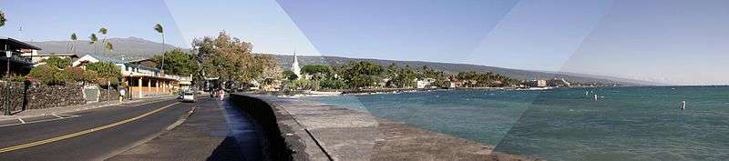
Ali'i Drive, Kailua's oceanfront downtown street, starts at Kailua Pier. It has also been given the designation as a Hawaii Scenic Byway called the "Royal Footsteps Along the Kona Coast".[17] This byway features archaeological sites that have survived for hundreds of years.
North of the pier is the Kamakahonu royal residence and Ahuʻena Heiau. Another royal residence is Huliheʻe Palace, used by members of the Hawaiian royal family until 1914.[18] The Historic Kona Inn and other shops are on the street.
Churches on the drive include Mokuaikaua Church, Hawaiʻi's first Christian church built in 1820, Saint Michael the Archangel Catholic Church, and Living Stones Church, a historical structure built after Mokuaikaua and used as a Christian Missionary landing location in the 1800-1900. Parks include La'aloa Bay (also known as Magic Sands or White Sands Beach) and Kahaluʻu Bay, which is a popular snorkeling location.
Boat tours which allow tourists to swim with dolphins, watch whales, and fish in the ocean usually depart from Honokohau Harbor.
Media
Kailua-Kona is served by television station KLEI and by the newspaper West Hawaii Today which is owned by the Black Press[19]
Education
The Hawaii Department of Education operates public schools. Kealakehe Elementary School, Kahakai Elementary School, Kealakehe Intermediate School, and Kealakehe High School are in the Kailua CDP.[20]
Notable residents
- Bret Bollinger, singer and bass guitarist in the band Pepper
- Michael Dell, founder and CEO of Dell Technologies
- Sandra Kurtzig, technology entrepreneur
- John Paul Thomas, artist
- Kaleo Wassman, singer and guitarist in Pepper and Sabotage Soundsystem
References
- ↑ U.S. Geological Survey Geographic Names Information System: Kailua City
- 1 2 "Geographic Identifiers: 2010 Demographic Profile Data (G001): Kailua City (Hawaii County), Hawaii". American Factfinder. U.S. Census Bureau. Retrieved May 30, 2017.
- ↑ U.S. Geological Survey Geographic Names Information System: Kailua-Kona Post Office
- ↑ "Kalaoa CDP, Hawaii Archived 2009-07-23 at the Wayback Machine.." U.S. Census Bureau. Retrieved on May 21, 2009.
- 1 2 3 4 Doughty, Andrew. Hawaii the Big Island Revealed: The Ultimate Guidebook, 4th ed. Lihuʻe: Wizard. ISBN 978-0-9717279-4-6. ISBN 0-9717279-4-5.
- ↑ "US Gazetteer files: 2010, 2000, and 1990". United States Census Bureau. 2011-02-12. Retrieved 2011-04-23.
- ↑ "Station Name: HI KAILUA KONA KE-AHOLE AP". National Oceanic and Atmospheric Administration. Retrieved 2013-04-02.
- ↑ "Monthly Normals Kailua Kona Int'l AP, Hawaii". WRCC/NCDC. Retrieved August 31, 2011.
- ↑ "American FactFinder". United States Census Bureau. Retrieved 2008-01-31.
- ↑ "Hawaii's Big Island economy improving despite tourism slowdown". Pacific Business News. 26 September 2014. Retrieved 3 January 2015.
- ↑ https://www.fhb.com/en/assets/File/Marketing/FHB_2013-14_HawaiiEconForecast.pdf
- ↑ "Palamanui may offer marine science degree". West Hawaii Today. Retrieved 3 January 2015.
- ↑ "UH heads lay out vision for Hawaii Community College — Palamanui". West Hawaii Today. Retrieved 3 January 2015.
- ↑ "Coping with vog". Retrieved 3 January 2015.
- ↑ "starbulletin.com – News – /2008/05/17/". Honolulu Star-Bulletin. Retrieved 3 January 2015.
- ↑ "Ironman World championships". Ironman.com. Retrieved 2016-05-22.
- ↑ Hawaii Scenic Byway – Royal Footsteps Along the Kona Coast
- ↑ Kona Historical Society, 1997, A Guide to Old Kona, University of Hawaii Press, ISBN 978-0-8248-2010-7
- ↑ "Official website". West Hawaii Today. Retrieved June 13, 2015.
- ↑ "Kailua CDP, Hawaii Archived 2009-06-04 at the Wayback Machine.." U.S. Census Bureau. Retrieved on May 21, 2009.
External links
| Wikimedia Commons has media related to Kailua-Kona, Hawaii. |
| Wikivoyage has a travel guide for Kailua-Kona. |
- Konaweb, community web site
- Kona Historical Society
- Hawaii Scenic Byways
- Kona-Kohala Chamber of Commerce
- North Kona shoreline access map at Hawaiʻi County web site
- Photosphere of Kailua-Kona by Gerald Besson