Sumoto, Hyōgo
| Sumoto 洲本市 | |||
|---|---|---|---|
| City | |||
 | |||
| |||
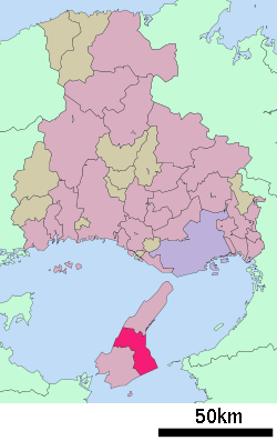 Location of Sumoto in Hyōgo Prefecture | |||
 Sumoto Location in Japan | |||
| Coordinates: 34°21′N 134°54′E / 34.350°N 134.900°ECoordinates: 34°21′N 134°54′E / 34.350°N 134.900°E | |||
| Country | Japan | ||
| Region | Kansai | ||
| Prefecture | Hyōgo Prefecture | ||
| Government | |||
| • Mayor | Michihiro Takeuchi | ||
| Area | |||
| • Total | 182.47 km2 (70.45 sq mi) | ||
| Population (April 30, 2017) | |||
| • Total | 45,090 | ||
| • Density | 250/km2 (640/sq mi) | ||
| Symbols | |||
| • Tree | Pine | ||
| • Flower | Narcissus and Rapeseed | ||
| • Bird | Plover | ||
| • Fish | Japanese Spanish mackerel (Scomberomorus niphonius) | ||
| Time zone | UTC+9 (JST) | ||
| City hall address |
3-4-10 Honmachi, Sumoto-shi, Hyōgo-ken 656-8686 | ||
| Website |
www | ||


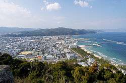
Sumoto (洲本市 Sumoto-shi) is a city located on Awaji Island, Hyōgo Prefecture, Japan. The city was founded on February 11, 1940. As of April 30, 2017, the city has an estimated population of 45,090 and a population density of 250 persons per km².[1] The total area is 182.47 km². On February 11, 2006, the town of Goshiki (from Tsuna District) was merged into Sumoto. Sumoto City is famous for Awaji onions, Naruto oranges and Kobe Beef.
Climate
Sumoto has a humid subtropical climate (Köppen climate classification Cfa) with hot summers and cool winters. Precipitation is significant throughout the year, but is somewhat lower in the winter.
| Climate data for Sumoto, Hyōgo | |||||||||||||
|---|---|---|---|---|---|---|---|---|---|---|---|---|---|
| Month | Jan | Feb | Mar | Apr | May | Jun | Jul | Aug | Sep | Oct | Nov | Dec | Year |
| Average high °C (°F) | 8.0 (46.4) |
8.4 (47.1) |
11.8 (53.2) |
17.8 (64) |
22.1 (71.8) |
25.1 (77.2) |
29.2 (84.6) |
30.6 (87.1) |
26.5 (79.7) |
20.8 (69.4) |
15.8 (60.4) |
10.7 (51.3) |
18.9 (66) |
| Daily mean °C (°F) | 4.7 (40.5) |
4.7 (40.5) |
7.6 (45.7) |
13.3 (55.9) |
17.7 (63.9) |
21.3 (70.3) |
25.3 (77.5) |
26.5 (79.7) |
22.9 (73.2) |
17.4 (63.3) |
12.5 (54.5) |
7.5 (45.5) |
15.1 (59.2) |
| Average low °C (°F) | 1.8 (35.2) |
1.6 (34.9) |
3.9 (39) |
9.4 (48.9) |
14.0 (57.2) |
18.2 (64.8) |
22.5 (72.5) |
23.5 (74.3) |
20.1 (68.2) |
14.5 (58.1) |
9.5 (49.1) |
4.6 (40.3) |
12 (53.5) |
| Average precipitation mm (inches) | 52.6 (2.071) |
62.2 (2.449) |
99.5 (3.917) |
150.8 (5.937) |
146.0 (5.748) |
235.3 (9.264) |
156.6 (6.165) |
126.6 (4.984) |
238.7 (9.398) |
130.2 (5.126) |
88.1 (3.469) |
41.4 (1.63) |
1,528 (60.158) |
| Average snowfall cm (inches) | 2 (0.8) |
3 (1.2) |
1 (0.4) |
0 (0) |
0 (0) |
0 (0) |
0 (0) |
0 (0) |
0 (0) |
0 (0) |
0 (0) |
0 (0) |
6 (2.4) |
| Average relative humidity (%) | 66 | 68 | 68 | 71 | 74 | 80 | 81 | 79 | 79 | 74 | 71 | 67 | 73 |
| Mean monthly sunshine hours | 145.7 | 142.4 | 177.5 | 182.6 | 203.3 | 159.0 | 202.7 | 220.7 | 156.1 | 162.8 | 141.5 | 140.6 | 2,034.9 |
| Source: NOAA (1961-1990)[2] | |||||||||||||
Schools
There are many elementary schools: Sumoto first, Sumoto second, Sumoto third, Ono, Kamo, Yura, Nakagawara, Aiga, Tsushi, Torikai, Sakai, Hiroishi, and Aihara.
There are five public junior high schools: Seiun, Suhama, Yura, Aiga, and Goshiki.
There are three high schools: Sumoto, Sumoto Jitsugyou, and Yanagi Gakuen.
Bicycle rental scheme
Jointly with Awaji and Minami Awaji, the city operates a low-cost electric bike rental scheme, designed to attract visitors to stay for more than one day in order to explore the island.[3]
References
- ↑ "Official website of Sumoto City" (in Japanese). Japan: Sumoto City. Retrieved 12 May 2017.
- ↑ "Sumoto Climate Normals 1961-1990". National Oceanic and Atmospheric Administration. Retrieved January 6, 2013.
- ↑ "Rental bicycles eyed to boost tourism". Yomiuri Shimbun. Japan. 19 July 2010. Retrieved 2 August 2010.
External links
| Wikimedia Commons has media related to Sumoto, Hyogo. |
- Sumoto City official website (in Japanese)
| Wards of Kobe | ||
|---|---|---|
| Core cities | ||
| Special cities | ||
| Cities | ||
| Districts | ||