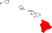
Kau, Hawaii
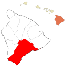
Kaʻū is the southernmost district of Hawaii County, Hawaii, located on the island of Hawaiʻi.
Kaʻū was one of the six original districts of ancient Hawaii on the island, known as moku.[1] It includes the areas of South Point (Ka Lae), Hawaiian Ocean View Estates (HOVE), Hawaiian Ocean View Ranchos (HOVR), now together known as Ocean View, Nīnole, Waiʻōhinu, Naʻālehu and Pāhala.[2]
The district contains much of Hawaii Volcanoes National Park, including the volcanoes Kīlauea and Mauna Loa, and Punaluʻu Black Sand Beach, Papakōlea (Green Sand) Beach and Kamilo Beach.[3] To the east of Kaʻū is the Puna District, and to the west is the South Kona District.[4]
Sugar cane was a large crop until 1996. Now coffee is growing in importance,[5] with the Kaʻū Coffee Festival held in Pāhala.[6]
Southernmost point
The southernmost point of any state in the United States is at Ka Lae Point in the Kaʻū District. It is almost the southernmost point in the whole country except that, technically, the United States Territory of Palmyra Island, although not part of a state within the US, is an incorporated territory (an integral part of the country) according to the doctrine of "incorporation" defined in the Supreme Court's Insular Cases; therefore Palmyra's south point on Holei Island at 5°52'15" N latitude is officially the southernmost point in the United States of America, not Ka Lae Point.[7]
Lender and Insurance Redlining Of Lava Zone 1 and 2
Kau shares much in common with the district of Puna, Hawaii. Both districts are situated on active volcanoes and contains large sections of land that are in Lava Flow Hazard Zones 1 and 2. Additionally, new lava zones 11, 12, and 13 are being established to account for current flow activity to reduce redlining.
Gallery
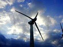 South Point Wind Farm in Kaʻū
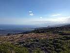 The view of the Ka'u coastline from HVNP. Looking southwest towards Na'alehu
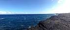 Much of the Ka'u coastline is made up of volcanic Pali. Looking southwest from HVNP
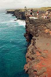 The Kaʻū district's Ka Lae Point, the southernmost point of any of the US States
References
- ↑ Lloyd J. Soehren (2010). "lookup of Kaʻū ". in Hawaiian Place Names. Ulukau, the Hawaiian Electronic Library. Retrieved September 28, 2010.
- ↑ Kaʻū Chamber of Commerce official web site
- ↑ John R. K. Clark (2001). Hawai'i place names: shores, beaches, and surf sites. University of Hawaii Press. p. 83. ISBN 978-0-8248-2451-8.
- ↑ Juvik and Juvik editors, 1998, Atlas of Hawaii, University of Hawaii Press, ISBN 978-0-8248-2125-8
- ↑ Kaʻū Coffee Growers Cooperative web site
- ↑ Kaʻū Coffee Festival official web site
- ↑ "GAO/OGC-98-5 – U.S. Insular Areas: Application of the U.S. Constitution". U.S. Government Printing Office. November 7, 1997. Retrieved March 18, 2018.
Coordinates: 19°6′0″N 155°36′0″W / 19.10000°N 155.60000°W