Western Visayas
| Western Visayas Kabisay-an Nakatundan Kanlurang Kabisayaan Region VI | |
|---|---|
| Region | |
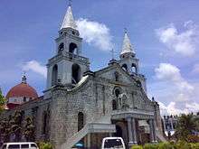  .jpg)  From upper-left to bottom-right: Jaro Cathedral (Iloilo); The Ruins (Negros Occidental); Boracay Island (Aklan); Roca Encantada House (Guimaras) | |
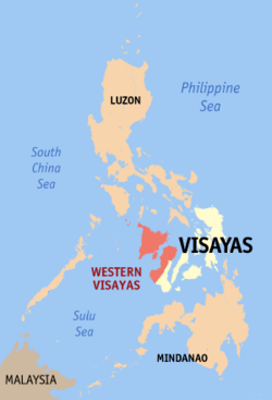 Location in the Philippines | |
| Coordinates: 10°35′N 122°35′E / 10.58°N 122.58°ECoordinates: 10°35′N 122°35′E / 10.58°N 122.58°E | |
| Country | Philippines |
| Island group | Visayas |
| Regional center | Iloilo City |
| Area | |
| • Total | 20,794.18 km2 (8,028.68 sq mi) |
| Population (2015 census)[1] | |
| • Total | 7,536,383 |
| • Density | 360/km2 (940/sq mi) |
| Time zone | UTC+8 (PST) |
| ISO 3166 code | PH-06 |
| Provinces | |
| Cities | |
| Municipalities | 117 |
| Barangays | 4,051 |
| Cong. districts | 16 |
| Languages | |
Western Visayas (Hiligaynon: Kabisay-an Nakatundan; Filipino: Kanlurang Kabisayaan) is an administrative region in the Philippines, numerically designated as Region VI. It consists of six provinces (Aklan, Antique, Capiz, Guimaras, Iloilo and Negros Occidental) and two highly urbanized cities (Bacolod City and Iloilo City). The regional center is Iloilo City.[2] The region is dominated by the native speakers of four Visayan languages: Kinaray-a, Hiligaynon, Aklanon and Capiznon. The land area of the region is 20,794.18 km2 (8,028.68 sq mi), and with a population of 7,536,383 inhabitants, it is the most populous region in the Visayas.
On May 29, 2015, the region was redefined, when Western Visayas (Region VI) both lost the province of Negros Occidental and the highly urbanized city of Bacolod to the newly formed Negros Island Region. However, the region was dissolved, with Negros Occidental and Bacolod returned to Western Visayas on August 9, 2017.
Etymology
The region's current name is in reference to its position in the greater Visayas area. The name was coined by American colonialists after the defeat of Filipino revolutionaries in Panay island. There have been proposals to rename the current Western Visayas region into the Madja-as region, the former name of the region prior to Spanish colonization in the 16th century. The proposed name is in reference to the Confederation of Madja-as, the former confederate kingdom of the area which existed between the 12th century until 1569 and was initially ruled by Datu Puti, the first monarch of western Visayas. The name is the oldest known reference to the entire western Visayas area.[3][4]
History
Regions first came into existence on September 24 of 1972, when the provinces of the Philippines were organized into 11 regions by Presidential Decree No. 1 as part of the Integrated Reorganization Plan by President Ferdinand Marcos. The provinces of Aklan, Antique, Capiz, Iloilo (including its then-subprovince of Guimaras), and Negros Occidental were grouped together to form the Western Visayas region.
The province of Palawan was transferred to Region VI (Western Visayas) on May 23, 2005 by Executive Order 429.[5] The Department of the Interior and Local Government announced in June 2005 that the transfer had been completed.[6] However, Palaweños criticized the move, citing a lack of consultation, with most residents in Puerto Princesa City and all municipalities but one preferring to stay with Region IV-B. Consequently, Administrative Order No. 129 was issued on August 19, 2005 to address this backlash. This Order directed the abeyance of Executive Order 429 pending the approval of an implementation plan for the orderly transfer of Palawan from Region IV-B to Region VI.[7] Hence, Palawan is currently still part of Region IV-B.
By virtue of Executive Order No. 183 issued on May 29 of 2015, by President Benigno Aquino III, the province of Negros Occidental and its capital, Bacolod City, were both removed from Western Visayas in order to form the Negros Island Region along with Negros Oriental.[8] But later regained Negros Occidental and its capital, Bacolod City back into Western Visayas on August 9, 2017 when President Rodrigo Duterte dissolved the Negros Island Region, revoking Executive Order No. 183, s. 2015 through the signage of Executive Order No. 38, citing the reason of the lack of funds to fully establish the NIR according to Benjamin Diokno, the Secretary of Budget and Management.[9]
Geography
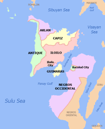
Western Visayas consists of the major island of Panay and the smaller Guimaras, as well as several outlying islands. It also includes the western half of the larger island of Negros. The region is bordered to the north by the Sibuyan Sea, northeast by the Visayan Sea, east by the province of Negros Oriental in Central Visayas, south by the Iloilo Strait and the Panay Gulf, and west by the Sulu Sea.
Administrative divisions
Western Visayas consists of 6 provinces, 2 highly urbanized cities, 14 component cities, 117 municipalities and 4,051 barangays.
| Province or HUC | Capital | Population (2015)[1] | Area[10] | Density | Cities | Muni. | Bgy. | |||||
|---|---|---|---|---|---|---|---|---|---|---|---|---|
| km2 | sq mi | /km2 | /sq mi | |||||||||
| Aklan | Kalibo | 12.8% | 574,823 | 1,821.42 | 703.25 | 320 | 830 | 0 | 17 | 327 | ||
| Antique | San Jose de Buenavista | 13.0% | 582,012 | 2,729.17 | 1,053.74 | 210 | 540 | 0 | 18 | 590 | ||
| Capiz | Roxas | 17.0% | 761,384 | 2,594.64 | 1,001.80 | 290 | 750 | 1 | 16 | 473 | ||
| Guimaras | Jordan | 3.9% | 174,613 | 604.57 | 233.43 | 290 | 750 | 0 | 5 | 98 | ||
| Iloilo | Iloilo City | 43.3% | 1,936,423 | 5,000.83 | 1,930.83 | 390 | 1,000 | 1 | 42 | 1,721 | ||
| Negros Occidental | Bacolod | 56.6% | 2,497,261 | 7,802.54 | 3,012.58 | 320 | 830 | 12 | 19 | 601 | ||
| Bacolod City | † | — | 12.5% | 561,875 | 162.67 | 62.81 | 3,500 | 9,100 | — | — | 61 | |
| Iloilo City | † | — | 10.0% | 447,992 | 78.34 | 30.25 | 5,700 | 15,000 | — | — | 180 | |
| Total | 7,536,383 | 20,794.18 | 8,028.68 | 220 | 570 | 16 | 117 | 4,051 | ||||
| ||||||||||||
| City | Population (2015)[1] | Area | Density | City class | Income class | Province | ||
|---|---|---|---|---|---|---|---|---|
| km2 | sq mi | /km2 | /sq mi | |||||
| Bacolod | 561,875 | 162.67 | 62.81 | 3,500 | 9,100 | Highly urbanized | 1st | Negros Occidental |
| Bago | 170,981 | 401.20 | 154.90 | 430 | 1,100 | Component | 2nd | Negros Occidental |
| Cadiz | 154,723 | 524.57 | 202.54 | 290 | 750 | Component | 2nd | Negros Occidental |
| Escalante | 94,070 | 192.76 | 74.43 | 490 | 1,300 | Component | 4th | Negros Occidental |
| Himamaylan | 106,880 | 367.04 | 141.71 | 290 | 750 | Component | 3rd | Negros Occidental |
| Iloilo City | 447,992 | 78.34 | 30.25 | 5,700 | 15,000 | Highly urbanized | 1st | Iloilo |
| Kabankalan | 181,977 | 697.35 | 269.25 | 260 | 670 | Component | 1st | Negros Occidental |
| La Carlota | 64,469 | 137.29 | 53.01 | 470 | 1,200 | Component | 4th | Negros Occidental |
| Passi | 80,544 | 251.39 | 97.06 | 320 | 830 | Component | 3rd | Iloilo |
| Roxas | 167,003 | 95.07 | 36.71 | 1,800 | 4,700 | Component | 1st | Capiz |
| Sagay | 146,264 | 330.34 | 127.54 | 440 | 1,100 | Component | 3rd | Negros Occidental |
| San Carlos | 132,536 | 451.50 | 174.33 | 290 | 750 | Component | 2nd | Negros Occidental |
| Silay | 126,930 | 214.80 | 82.93 | 590 | 1,500 | Component | 3rd | Negros Occidental |
| Sipalay | 70,070 | 379.78 | 146.63 | 180 | 470 | Component | 4th | Negros Occidental |
| Talisay | 102,214 | 201.18 | 77.68 | 510 | 1,300 | Component | 4th | Negros Occidental |
| Victorias | 87,933 | 133.92 | 51.71 | 660 | 1,700 | Component | 4th | Negros Occidental |
Demographics
| Population census of Western Visayas | ||
|---|---|---|
| Year | Pop. | ±% p.a. |
| 1990 | 5,393,333 | — |
| 2000 | 6,211,038 | +1.42% |
| 2010 | 7,102,438 | +1.35% |
| 2015 | 7,536,383 | +1.14% |
| Data in 2015 includes Negros Occidental and Bacolod. Source: Philippine Statistics Authority[1][11] | ||
Languages
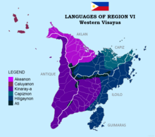
The native languages of Western Visayas are:
- Aklanon/Akeanon, spoken in Aklan and northwestern Capiz.
- Capiznon, spoken in Capiz, northeastern Iloilo, and eastern Aklan.
- Cebuano, spoken in northeastern Negros Occidental.
- Hiligaynon, spoken in Iloilo, Negros Occidental, Guimaras, Capiz, Antique, and Aklan. It is the regional lingua franca.
- Kinaray-a, spoken in Antique, southwestern half of Iloilo, Guimaras, western Capiz, and southwestern Aklan.
- Malaynon, spoken in northwestern Aklan including Boracay Island.
- Caluyanon, spoken in the Semirara Islands (Semirara, Caluya, and Sibay Islands).
Transportation
Airports
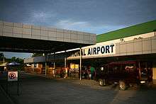
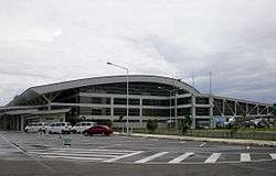
International
Domestic
- Bacolod–Silay Airport (Silay City, Negros Occidental)
- Godofredo P. Ramos Airport (Caticlan, Malay, Aklan)
- Roxas Airport (Roxas City, Capiz)
- Evelio Javier Airport (Funda-Dalipe, San Jose de Buenavista, Antique)
Municipal
- Semirara Airport (Semirara Island, Caluya, Antique)
Other
- Sipalay Airport (Sipalay, Negros Occidental)
- Kabankalan City Domestic Airport (Kabankalan, Negros Occidental)
Rail
Proposals to re-connect again Iloilo-Roxas, Iloilo-Kalibo, Iloilo-Malay (Aklan) and Iloilo-San Jose (Antique) from the Iloilo City via rail was included in the revival of the currently defunct Panay Railways network which has a station in Santa Barbara town proper.[12]
References
- 1 2 3 4 Census of Population (2015). "Region VI (Western Visayas)". Total Population by Province, City, Municipality and Barangay. PSA. Retrieved 20 June 2016.
- ↑ "History of Urban Growth of Iloilo City". Iloilo City Government. Archived from the original on June 30, 2012. Retrieved June 28, 2012.
- ↑ http://opinion.inquirer.net/95645/change-name-will-good-philippines
- ↑ http://news.abs-cbn.com/news/06/13/17/should-the-philippines-be-renamed-historian-weighs-in
- 1 2 President of the Philippines. "Executive order No. 429". Office of the Press Secretary. Archived from the original on 2007-07-07.
- ↑ "Palawan, Puerto Princesa Transfer to Region VI" (Press release). Government of the Philippines - News. 3 June 2005.
- 1 2 President of the Philippines (August 19, 2005). "Administrative Order No. 129". Office of the Press Secretary. Archived from the original on 2006-07-13.
- ↑ "Executive Order No. 183, s. 2015". Official Gazette (Philippines). May 29, 2015. Retrieved June 5, 2015.
- ↑ "Duterte dissolves Negros Island Region". Rappler. August 9, 2017. Retrieved August 10, 2017.
- ↑ "PSGC Interactive; List of Provinces". Philippine Statistics Authority. Retrieved 29 March 2016.
- ↑ "Population and Annual Growth Rates for The Philippines and Its Regions, Provinces, and Highly Urbanized Cities" (PDF). 2010 Census and Housing Population. Philippine Statistics Authority. Archived from the original (PDF) on 28 September 2013. Retrieved 9 August 2013.
- ↑ Salvilla, Rex S. (July 28, 2006). "Anything Under the Sun: Panay Railways". The News Today. TNT Publishing, Inc. Retrieved June 12, 2008.
External links

- Philippine Standard Geographic Code

