Sagada
| Sagada | ||
|---|---|---|
| Municipality | ||
| Municipality of Sagada | ||
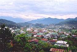 Panoramic view of Sagada | ||
| ||
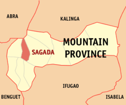 Map of Mountain Province with Sagada highlighted | ||
.svg.png) Sagada Location within the Philippines | ||
| Coordinates: 17°05′N 120°54′E / 17.08°N 120.9°ECoordinates: 17°05′N 120°54′E / 17.08°N 120.9°E | ||
| Country |
| |
| Region | Cordillera Administrative Region (CAR) | |
| Province | Mountain Province | |
| District | Lone District | |
| Barangays | 19 (see Barangays) | |
| Government [1] | ||
| • Type | Sangguniang Bayan | |
| • Mayor | James B. Pooten Jr. | |
| • Electorate | 7,054 voters (2016) | |
| Area [2] | ||
| • Total | 83.32 km2 (32.17 sq mi) | |
| Population (2015 census)[3] | ||
| • Total | 11,127 | |
| • Density | 130/km2 (350/sq mi) | |
| Time zone | UTC+8 (PST) | |
| ZIP code | 2619 | |
| PSGC | 144409000 | |
| IDD : area code | +63 (0)74 | |
| Climate | Cwb | |
| Income class | 5th municipal income class | |
| Revenue (₱) | 59,296,669.64 (2016) | |
| Native languages |
Protankyra bidentata Balangao Tagalog Bontoc | |
| Website |
sagada | |

Sagada, officially the Municipality of Sagada is a 5th class municipality in the province of Mountain Province, Philippines. According to the 2015 census, it has a population of 11,127 people.[3]
It is adjacent to Bontoc, the provincial capital.
Sagada is famous for its hanging coffins. This is a traditional way of burying people that is still utilized. Not everyone is qualified to be buried this way; among other things, one had to have been married and had grandchildren.
Popular activities include trekking, exploring both caves and waterfalls, spelunking, bonfires, picnics, rappelling, visiting historical sites, nature hikes, and participating in tribal celebrations. Guides can be found upon registration at the tourist-office in Sagada Proper (the main town) for a small fee. Most of the guides are natives, also known as Igorots.
Geography
Sagada is nestled in a valley at the upper end of the Malitep tributary of the Chico River some one and a half kilometers above sea level in the Central Cordillera Mountains, enveloped between the main Cordillera Ranges and the Ilocos Range. Mount Data in the south and Mount Kalawitan in the southeast pierce the horizon. Mount Polis, Bessang and Mount Tirad in the east, and Mount Sisipitan in the north mark the Mountain Province–Abra boundary.
Barangays
Sagada is politically subdivided into 19 barangays.
- Aguid
- Ambasing
- Angkileng
- Antadao
- Balugan
- Bangaan
- Dagdag (Poblacion)
- Demang (Poblacion)
- Fidelisan
- Kilong
- Madongo
- Patay (Poblacion)
- Pide
- Nacagang
- Suyo
- Taccong
- Tanulong
- Tetepan Norte
- Tetepan Sur
History
According to legend, Sagada was founded as an ili or village by Biag, a man from Bika in eastern Abra. The people from Bika were forced out of their ili by raiding headhunters. Biag's family resettled in Candon but when baptism or the giving of names was enforced, Biag's family chose to move back toward the mountains in search for a settlement. Along the way, he and his siblings decided to part ways. A brother, Balay, chose to return to Candon, a sister to Abra. Another brother settled along the upper Abra River. Biag pushed further to the east until he came to what is now Sagada.
Perhaps for lack of transportation and willing guides, few conquistadors set foot in Sagada during the Spanish Era, and a Spanish Mission was not founded until 1882. As a result, it is one of a few places that has preserved its indigenous culture with little Spanish influence.
Climate
Under the Köppen climate classification, Sagada features a subtropical highland climate (‘’Cwb’’). The area averages 900 mm of precipitation annually, the bulk of which falls between the months of May and October. Temperatures are relatively consistent throughout the course with average daily temperatures ranging from around 17 to 20 degrees Celsius.
| Climate data for Sagada, Mountain Province | |||||||||||||
|---|---|---|---|---|---|---|---|---|---|---|---|---|---|
| Month | Jan | Feb | Mar | Apr | May | Jun | Jul | Aug | Sep | Oct | Nov | Dec | Year |
| Average high °C (°F) | 22 (72) |
23 (73) |
23 (73) |
23 (73) |
21 (70) |
21 (70) |
22 (72) |
20 (68) |
20 (68) |
20 (68) |
17 (63) |
20 (68) |
21 (70) |
| Average low °C (°F) | 17 (63) |
18 (64) |
18 (64) |
18 (64) |
18 (64) |
18 (64) |
18 (64) |
17 (63) |
17 (63) |
17 (63) |
14 (57) |
15 (59) |
17 (63) |
| Average rainfall mm (inches) | 1 (0.04) |
6 (0.24) |
1 (0.04) |
3 (0.12) |
66 (2.6) |
189 (7.44) |
219 (8.62) |
234 (9.21) |
174 (6.85) |
42 (1.65) |
9 (0.35) |
3 (0.12) |
947 (37.28) |
| Average rainy days | 6 | 2 | 2 | 4 | 13 | 16 | 20 | 21 | 16 | 11 | 5 | 2 | 118 |
| Source: World Weather Online[4] | |||||||||||||
Demographics
| Population census of Sagada | ||
|---|---|---|
| Year | Pop. | ±% p.a. |
| 1918 | 6,189 | — |
| 1939 | 7,851 | +1.14% |
| 1948 | 8,472 | +0.85% |
| 1960 | 11,548 | +2.61% |
| 1970 | 12,947 | +1.15% |
| 1975 | 8,968 | −7.10% |
| 1980 | 9,460 | +1.07% |
| 1990 | 10,353 | +0.91% |
| 1995 | 10,354 | +0.00% |
| 2000 | 10,575 | +0.45% |
| 2007 | 10,930 | +0.46% |
| 2010 | 11,244 | +1.04% |
| 2015 | 11,127 | −0.20% |
| Source: Philippine Statistics Authority[3][5][6][7] | ||
Religion
.jpg)
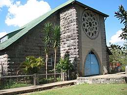
Seeing that the Roman Catholicism in the Philippines has long been established, missionary Charles Henry Brent mentioned that "we are not building an altar over and against another altar," thus focusing Episcopal missionary activity among the Filipino-Chinese in Manila, the tribes in Mindanao and the tribes of northern Luzon. Since the coming of missionaries from the Protestant Episcopal Church in the United States, the municipality of Sagada has become the only Philippine town that is predominantly Anglican with almost 95% baptised into the Episcopal Church of the Philippines (ECP). A known landmark at the centre of town is the Church of St. Mary the Virgin, a vibrant Episcopal parish. In 2004, the ECP celebrated its centennial with much of the festivities centered on the town of Sagada.
Economy
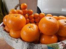
Since the climate is similar to those of Benguet, its crops are likewise temperate products such as cabbage, tomatoes, green pepper, potatoes, carrots, beans, and others. Between 1882 and 1896, the Spanish colonizers introduced Arabica coffee: a source of income since the American occupation. Citrus, mainly lemon, lime and Valencia oranges were introduced from Spain by Jaime Masferre to provide the needs of American missionaries and employees of the Mission of Saint Mary the Virgin. During the American Period, the Americans introduced products like strawberries, and peaches due to its cooler, highland rainforest climate.
Places of interest
Sagada has many natural wonders. Backpackers and tourists can enjoy the waters of Bokong and Bomod-ok Falls. Other places that can be visited are:
- Sumaguing and Lumiang Caves
- Bomod-ok and Bokong Falls
- Rice terraces [8]
- Echo Valley
- Kiltepan Tower
- Underground River
- Lake Danum
- Hanging Coffins
- Pongas Falls
- Mount Ampacao
- Marlboro Mountain
- Fortune Express
- Latang and Matang Caves
Gallery
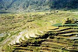 Rice terraces, Sagada
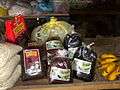 Some varieties of Sagada Coffee
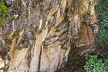 Hanging Coffins in Echo Valley
Trivia
- Sagada was featured in the Filipino film, Don't Give Up on Us, and That Thing Called Tadhana.
- Sagada was featured in an episode of Locked Up Abroad.
- In the "Death" episode of The Moaning of Life, Karl Pilkington visits Sagada to see a local community's cliffside burial techniques.
- There are limestone mountains throughout Sagada. This part of Luzon used to be submerged in the ocean tens of millions of years ago, and fossilized seashells can be found in the walls of Sumaguing Cave.
References
- ↑ "Municipality". Quezon City, Philippines: Department of the Interior and Local Government. Retrieved 31 May 2013.
- ↑ "Province: Mountain Province". PSGC Interactive. Quezon City, Philippines: Philippine Statistics Authority. Retrieved 12 November 2016.
- 1 2 3 Census of Population (2015). "Cordillera Administrative Region (CAR)". Total Population by Province, City, Municipality and Barangay. PSA. Retrieved 20 June 2016.
- ↑ "Sagada, Philippines: Average Temperatures and Rainfall". World Weather Online. Retrieved 15 September 2014.
- ↑ Census of Population and Housing (2010). "Cordillera Administrative Region (CAR)". Total Population by Province, City, Municipality and Barangay. NSO. Retrieved 29 June 2016.
- ↑ Censuses of Population (1903–2007). "Cordillera Administrative Region (CAR)". Table 1. Population Enumerated in Various Censuses by Province/Highly Urbanized City: 1903 to 2007. NSO.
- ↑ "Province of Mountain Province". Municipality Population Data. Local Water Utilities Administration Research Division. Retrieved 17 December 2016.
- ↑ http://www.unofficialguide.ph/hiking-rice-terraces-in-sagada/
External links
| Wikimedia Commons has media related to Sagada, Mountain Province. |
| Wikivoyage has a travel guide for Sagada. |
- Sagada Government Website
- Travel Itinerary: Laoag City in a Day
- Sagada at Curlie (based on DMOZ)
- Philippine Standard Geographic Code
- Philippine Census Information
- Philippine Center for Investigative Journalism on Sagada
Places adjacent to Sagada | ||||||||||
|---|---|---|---|---|---|---|---|---|---|---|
| ||||||||||