|
Metro area [1] |
Population (2015) [4] |
Area [5][6] |
Density (2015) |
Managing agency |
|
|
km2 |
sq mi |
/km2 |
/sq mi |
|
|
Metro Cebu |
2,849,213 |
1,053.19 |
406.64 |
2,700 |
7,000 |
Metro Cebu Development and Coordinating Board[7] |
| 10°06′12″N 123°38′26″E / 10.1033°N 123.6405°E / 10.1033; 123.6405 (Carcar) |
Carcar |
7000420000000000000♠4.2% | 119,664 |
116.78 |
45.09 |
1,000 |
2,600 |
| 10°18′32″N 123°53′35″E / 10.3090°N 123.8930°E / 10.3090; 123.8930 (Cebu City) |
Cebu City |
7001324000000000000♠32.4% | 922,611 |
315.00 |
121.62 |
2,900 |
7,500 |
| 10°27′26″N 124°00′37″E / 10.4571°N 124.0104°E / 10.4571; 124.0104 (Compostela) |
Compostela |
7000170000000000000♠1.7% | 47,898 |
53.90 |
20.81 |
890 |
2,300 |
| 10°22′35″N 123°57′26″E / 10.3765°N 123.9572°E / 10.3765; 123.9572 (Consolacion) |
Consolacion |
7000460000000099999♠4.6% | 131,528 |
37.03 |
14.30 |
3,600 |
9,300 |
| 10°15′05″N 123°57′00″E / 10.2515°N 123.9499°E / 10.2515; 123.9499 (Cordova) |
Cordova |
7000210000000000000♠2.1% | 59,712 |
17.15 |
6.62 |
3,500 |
9,100 |
| 10°31′14″N 124°01′37″E / 10.5205°N 124.0270°E / 10.5205; 124.0270 (Danao) |
Danao |
7000480000000000000♠4.8% | 136,471 |
107.30 |
41.43 |
1,300 |
3,400 |
| 10°18′39″N 123°56′58″E / 10.3109°N 123.9494°E / 10.3109; 123.9494 (Lapu-Lapu) |
Lapu-Lapu (Opon) |
7001143000000000000♠14.3% | 408,112 |
58.10 |
22.43 |
7,000 |
18,000 |
| 10°24′01″N 123°59′57″E / 10.4002°N 123.9993°E / 10.4002; 123.9993 (Liloan) |
Liloan |
7000420000000000000♠4.2% | 118,753 |
45.92 |
17.73 |
2,600 |
6,700 |
| 10°19′28″N 123°56′34″E / 10.3245°N 123.9428°E / 10.3245; 123.9428 (Mandaue) |
Mandaue |
7001127000000000000♠12.7% | 362,654 |
25.18 |
9.72 |
14,000 |
36,000 |
| 10°14′42″N 123°47′47″E / 10.2450°N 123.7964°E / 10.2450; 123.7964 (Minglanilla) |
Minglanilla |
7000460000000099999♠4.6% | 132,135 |
65.60 |
25.33 |
2,000 |
5,200 |
| 10°12′33″N 123°45′24″E / 10.2093°N 123.7567°E / 10.2093; 123.7567 (Naga) |
Naga |
7000410009999999999♠4.1% | 115,750 |
101.97 |
39.37 |
1,100 |
2,800 |
| 10°09′51″N 123°42′21″E / 10.1643°N 123.7058°E / 10.1643; 123.7058 (San Fernando) |
San Fernando |
7000230000000099999♠2.3% | 66,280 |
69.39 |
26.79 |
960 |
2,500 |
| 10°14′41″N 123°50′50″E / 10.2446°N 123.8473°E / 10.2446; 123.8473 (Talisay) |
Talisay |
7000800000000000000♠8.0% | 227,645 |
39.87 |
15.39 |
5,700 |
15,000 |
|
Metro Davao |
2,516,216 |
3,964.95 |
1,530.88 |
630 |
1,600 |
Davao Integrated Development Program Board[8] |
| 7°21′20″N 125°42′16″E / 7.3556°N 125.7045°E / 7.3556; 125.7045 (Carmen) |
Carmen |
7000300000000000000♠3.0% | 74,679 |
166.00 |
64.09 |
450 |
1,200 |
| 7°03′50″N 125°36′30″E / 7.0639°N 125.6083°E / 7.0639; 125.6083 (Davao City) |
Davao City |
7001649000000000000♠64.9% | 1,632,991 |
2,443.61 |
943.48 |
670 |
1,700 |
| 6°44′39″N 125°21′23″E / 6.7443°N 125.3565°E / 6.7443; 125.3565 (Digos) |
Digos |
7000670000000000000♠6.7% | 169,393 |
287.10 |
110.85 |
590 |
1,500 |
| 7°18′01″N 125°40′57″E / 7.3004°N 125.6826°E / 7.3004; 125.6826 (Panabo) |
Panabo |
7000730000000000000♠7.3% | 184,599 |
251.23 |
97.00 |
730 |
1,900 |
| 7°04′28″N 125°42′31″E / 7.0744°N 125.7086°E / 7.0744; 125.7086 (Samal) |
Samal |
7000410009999999999♠4.1% | 104,123 |
301.30 |
116.33 |
350 |
910 |
| 6°50′02″N 125°24′55″E / 6.8340°N 125.4154°E / 6.8340; 125.4154 (Santa Cruz) |
Santa Cruz |
7000360000000000000♠3.6% | 90,987 |
319.91 |
123.52 |
280 |
730 |
| 7°26′48″N 125°48′34″E / 7.4468°N 125.8095°E / 7.4468; 125.8095 (Tagum) |
Tagum |
7001103000000000000♠10.3% | 259,444 |
195.80 |
75.60 |
1,300 |
3,400 |
|
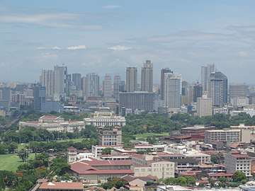
Metro Manila |
12,877,253 |
633.11 |
244.45 |
20,000 |
52,000 |
Metropolitan Manila Development Authority |
| 14°39′26″N 120°59′03″E / 14.6571°N 120.9841°E / 14.6571; 120.9841 (Caloocan) |
Caloocan |
7001123000000000000♠12.3% | 1,583,978 |
53.20 |
20.54 |
30,000 |
78,000 |
| 14°28′50″N 120°58′55″E / 14.4806°N 120.9819°E / 14.4806; 120.9819 (Las Piñas) |
Las Piñas |
7000460000000099999♠4.6% | 588,894 |
32.02 |
12.36 |
18,000 |
47,000 |
| 14°33′24″N 121°01′25″E / 14.5568°N 121.0235°E / 14.5568; 121.0235 (Makati) |
Makati |
7000450000000000000♠4.5% | 582,602 |
27.36 |
10.56 |
21,000 |
54,000 |
| 14°40′31″N 120°57′26″E / 14.6752°N 120.9573°E / 14.6752; 120.9573 (Malabon) |
Malabon |
7000280000000099999♠2.8% | 365,525 |
15.96 |
6.16 |
23,000 |
60,000 |
| 14°34′39″N 121°02′00″E / 14.5774°N 121.0334°E / 14.5774; 121.0334 (Mandaluyong) |
Mandaluyong |
7000300000000000000♠3.0% | 386,276 |
11.06 |
4.27 |
35,000 |
91,000 |
| 14°35′26″N 120°58′48″E / 14.5906°N 120.9799°E / 14.5906; 120.9799 (Manila) |
Manila |
7001138000000000000♠13.8% | 1,780,148 |
42.88 |
16.56 |
42,000 |
110,000 |
| 14°37′59″N 121°05′57″E / 14.6331°N 121.0993°E / 14.6331; 121.0993 (Marikina) |
Marikina |
7000350000000000000♠3.5% | 450,741 |
22.64 |
8.74 |
20,000 |
52,000 |
| 15°42′47″N 120°54′15″E / 15.7131°N 120.9041°E / 15.7131; 120.9041 (Muntinlupa) |
Muntinlupa |
7000390000000000000♠3.9% | 504,509 |
41.67 |
16.09 |
12,000 |
31,000 |
| 14°39′25″N 120°56′52″E / 14.6569°N 120.9478°E / 14.6569; 120.9478 (Navotas) |
Navotas |
7000190000000000000♠1.9% | 249,463 |
11.51 |
4.44 |
22,000 |
57,000 |
| 14°30′03″N 120°59′29″E / 14.5007°N 120.9915°E / 14.5007; 120.9915 (Parañaque) |
Parañaque |
7000520000000000000♠5.2% | 665,822 |
47.28 |
18.25 |
14,000 |
36,000 |
| 14°32′37″N 120°59′43″E / 14.5437°N 120.9954°E / 14.5437; 120.9954 (Pasay) |
Pasay |
7000320000000000000♠3.2% | 416,522 |
18.64 |
7.20 |
22,000 |
57,000 |
| 14°33′38″N 121°04′36″E / 14.5605°N 121.0767°E / 14.5605; 121.0767 (Pasig) |
Pasig |
7000590000000000000♠5.9% | 755,300 |
31.46 |
12.15 |
24,000 |
62,000 |
| 14°32′32″N 121°03′55″E / 14.5421°N 121.0654°E / 14.5421; 121.0654 (Pateros) |
Pateros |
6999500000000000000♠0.5% | 63,840 |
1.76 |
0.68 |
36,000 |
93,000 |
| 14°39′03″N 121°02′55″E / 14.6509°N 121.0486°E / 14.6509; 121.0486 (Quezon City) |
Quezon City |
7001228000000000000♠22.8% | 2,936,116 |
165.33 |
63.83 |
18,000 |
47,000 |
| 14°36′17″N 121°01′48″E / 14.6047°N 121.0299°E / 14.6047; 121.0299 (San Juan) |
San Juan |
6999900000000000000♠0.9% | 122,180 |
5.87 |
2.27 |
21,000 |
54,000 |
| 14°31′36″N 121°04′28″E / 14.5266°N 121.0744°E / 14.5266; 121.0744 (Taguig) |
Taguig |
7000630000000000000♠6.3% | 804,915 |
45.18 |
17.44 |
18,000 |
47,000 |
| 14°42′28″N 120°56′46″E / 14.7077°N 120.9462°E / 14.7077; 120.9462 (Valenzuela) |
Valenzuela |
7000480000000000000♠4.8% | 620,422 |
45.75 |
17.66 |
14,000 |
36,000 |
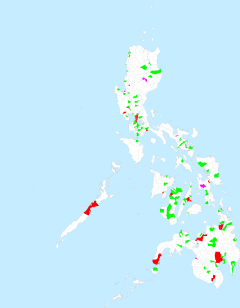
 Metro Manila
 Metro Cebu
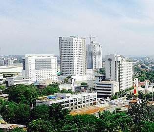 Metro Davao