Budgam district
| Budgam District | |
|---|---|
| District | |
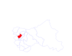 Location map for Budgam District in Jammu & Kashmir state | |
 Budgam District Location of the district headquarters in India | |
| Coordinates: 34°1′12″N 74°46′48″E / 34.02000°N 74.78000°ECoordinates: 34°1′12″N 74°46′48″E / 34.02000°N 74.78000°E | |
| Country |
|
| State |
|
| Established | 1979 |
| Founded by | Aga Syed Yousuf |
| Headquarters | Budgam |
| Government | |
| • Type | Democracy |
| Area | |
| • Total | 1,370 km2 (530 sq mi) |
| Population (2011) | |
| • Total | 735,753 |
| • Density | 537/km2 (1,390/sq mi) |
| Languages | |
| • Official | Urdu Kashmiri |
| Time zone | UTC+5:30 (IST) |
| Vehicle registration | JK04 |
| Sex ratio | 1.13250283 ♂/♀ |
| Literacy | 57.98% |
| Villages | Khansahib, Parnewa, Berwah, Chadora, Wahabpora |
| Website |
budgam |
Budgam District is a district of the state of Jammu and Kashmir in India. Created in 1979 with its headquarters at Budgam, it is the second district in Kashmir valley after Kargil where Shia population is found in large numbers.[1]
Administration
Budgam district is the closest district to capital Srinagar (11 km). Budgam district came into existence in 1979, prior to which it was part of Srinagar district. In former times, Budgam was a part of Baramulla district, when Srinagar itself was a constituent of the Anantnag district. It was then known as tehsil Sri Pratap. Historical records suggests that Budgam was also referred to as Pargana Deesu. According to the well-known chronicler Khawaja Azam Demari, the area was also known as Deedmarbag. Budgam District borders the districts of Baramullah and Srinagar in the north, Pulwama in the south and Poonch in the south west. It consists of eight blocks: Beerwah, Magam Budgam, B.K.Pora, Khan Sahib, Khag, Narbal and Chadoora.[2] Each block consists of a number of panchayats.The district is subdivided into the seven tehsils of Charari Sharief Tehsil, Magam tehsil, Beerwah Tehsil, Budgam Tehsil, Chadoora Tehsil, and Khansahib Tehsil, Khag Tehsil.[3]
Demography
According to the 2011 census Badgam district has a population of 735,753,[4] roughly equal to the nation of Guyana[5] or the US state of Alaska,[6] making it 494th in India (out of a total of 640).[4] The district has a population density of 537 inhabitants per square kilometre (1,390/sq mi) .[4] Its population growth rate over the decade 2001-2011 was 21.18%.[4] Badgam has a sex ratio of 883 females for every 1000 males,[4] and a literacy rate of 57.98%.,[4] an increase from 39.54% in 2001. This is attributed to educational institutions in the district. There are 98 schools in Budgam, both private and public, 33 of which are Higher Secondary Schools. Budgam has one government degree college, near Paller Village.Budgam is of one of backward districts in kashmir till date because some political issues.Budgam is district is also known to its great Muslim preachers as:Baba-Hanif-Ud-Din, locally the graveyard is known as "Baba sabin Ziyarath" which is situated at the most beautiful mountain which ends up in Rathsun, a small cute village.The people of Rathsun are very kind, as from the old times.Magam is one of the main town in budgam right now, because it is approximately at centre of the district budgam. Ompora, charar Sharif, kralpora and soibugh are highly populated localities of Budgam district. Magam, Ichgam, Iskandarpora, Wahabpora villages of Budgam district are the biggest villages with Shia population.
Attractions
.jpg)
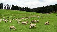
Budgam contains the only airport in Kashmir valley. The district's main tourist attractions are Doodhpathri, Yusmarg, Tosamaidan, Nilnag, Khag Mt Tatakuti, and Pehjan.District Budgam offers many stunning locales and has tremendous tourism potential that has largely remained untapped so far. The attractive places that can be visited are Doodpather, Yousmarg, Tosmaidan, Nilnag and Khag. Kani shawl adomed the caesar's court and was looked upon by Mughals and later by Nawabs as mark of nobility. In 1776 Napoleon presented a Kani shawl to his wife Josephine and with that took off a new fashion trend in Europe The revered shrine of Sheikh Noor-ud-din Wali can also be found in the Charari Sharief Tehsil of Budgam district.Worlds biggest chinar is in District Budam (Chatergam). The Budgam railway station is located in Ompora town nearly 2.5 km from district headquarters and 9 km from city centre Lalchowk. It is the biggest railway station in Kashmir division. This railway station has administrative head controlling the rail service in Kashmir valley.Outside railway station Ompora (Budgam) there is a big hospital which is Budgam district's first private hospital.
Notable people
- Sheikh ul Aalam of chrar sharief who spread Islam in valley.
- Syed Ali Aalibalkhi of pakharpora.
- A ziarat of drygam
- Syed saaleh of khansahab.
- Aga Syed Yusuf Al-Moosavi Al-Safavi,
- Aga Syed Mohammad Baqir Kirmani
- Aga Syed Mohammad Fazlullah
- Sir Syed Sani Mawlana Syed Ali Shah Bukhari, religious and political leader
References
- ↑ "Are Kashmiri Shias The Next Pandits?". 14 November 2013.
- ↑ Statement showing the number of blocks in respect of 22 Districts of Jammu and Kashmir State including newly Created Districts Archived 10 September 2008 at the Wayback Machine. dated 2008-03-13, accessed 2008-08-30
- ↑ "ERO's and AERO's". Chief Electoral Officer, Jammu and Kashmir. Archived from the original on 2008-10-22. Retrieved 2008-08-28.
- 1 2 3 4 5 6 "District Census 2011". Census2011.co.in. 2011. Retrieved 2011-09-30.
- ↑ US Directorate of Intelligence. "Country Comparison:Population". Retrieved 2011-10-01.
Guyana 744,768
- ↑ "2010 Resident Population Data". U. S. Census Bureau. Archived from the original on 2011-01-01. Retrieved 2011-09-30.
Alaska 710,231
External links
- Risingkashmir.in
- Greaterkashmir.com
- Kashmirtimes.com
- Kashmirwatch.com
- Kashmirmonitor.org
- Taghribnews.com