Ramban district
| Ramban district | |
|---|---|
| District of Jammu and Kashmir | |
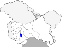 Location of Ramban district in Jammu and Kashmir | |
| Country | India |
| State | Jammu and Kashmir |
| Administrative division | Jammu Division |
| Headquarters | Ramban |
| Tehsils | 1. Banihal, 2. Ramban |
| Area | |
| • Total | 1,329 km2 (513 sq mi) |
| Population (2011) | |
| • Total | 283,713 |
| • Density | 210/km2 (550/sq mi) |
| • Urban | 4.16% [1] |
| Demographics | |
| • Literacy | 54.27% [2] |
| • Sex ratio | 902 |
| Vehicle registration | JK-19 |
| Major highways | NH-1A |
| Coordinates | 33°14′24″N 75°14′24″E / 33.24000°N 75.24000°ECoordinates: 33°14′24″N 75°14′24″E / 33.24000°N 75.24000°E |
| Website | Official website |
Ramban is one of the 22 districts in the state of Jammu and Kashmir, India. Ramban is located in the lap of Pir Panjal range of the mighty Himalayas. It was carved out of erstwhile Doda District keeping in view the backwardness, remoteness and aspiration of people of the area. District Ramban started functioning as independent unit on 1 April 2007.[3] Ramban town is the district headquarters. The town is located midway between Jammu and Srinagar along the Chenab river, on National Highway-44, (originally National Highway 1A (India)) approximately 150 km from Jammu and Srinagar.[4]

Administration
Ramban District is divided into seven tehsils: Banihal, Ramban, Khari, Rajgarh, Batote, Gool and Pogal Paristan (Ukhral).[5]
Each tehsil has its tehsildar, who is the administrative head. The district consisted of 116 census villages and 127 revenue villages in 2001. The total number of panchayat Halqas in the district was 124.
Geography
Ramban district is 1,156 metres (3,792 feet) above sea level. The boundary lines of Ramban district encompass hill station Patnitop as its southernmost point, Assar on its eastern edge, Gool to the west, and Banihal to the north. Terrain of district Ramban is tough and hilly. District Ramban shares its boundary with Reasi, Udhampur, Doda, Anantnag and Kulgam.[6]
Climate
The climate of the District varies according to altitude. The temperature rises as high as 42 °C in the low-lying areas like Ramban town located in between steep Mountains on the banks of river Chenab and drops to sub zero in the high altitude areas like Sangaldan,Gool, Dhagantop, Asthanmarg,Lalagundi, Budhan. The working season in most of the district is about eight months because of typical weather conditions in the district.
Politics
Ramban district has three assembly constituencies: Ramban, Banihal and Gool.[7]
Demographics
According to the 2011 census, Ramban district has a population of 283,713.[8] roughly equal to the nation of Barbados.[9] This gives it a ranking of 573rd in India (out of a total of 640).[8] The district has a population density of 213 inhabitants per square kilometre (550/sq mi) .[8] Its population growth rate over the decade 2001-2011 was 31.81%.[8] Ramban has a sex ratio of 901 females for every 1000 males,[8] and a literacy rate of 54.27%.[8]
Kashmiri and its dialects (Poguli and Sirazi) is the most widely spoken language in the district. The other languages spoken here are Urdu, Punjabi, Dogri, and Gojri. Ramban has a Muslim majority, with Muslims constituting about 70% and Hindus constituting about 28% of the population.
Tourist Attractions
Sanasar
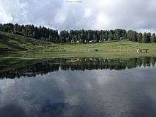
Things to do in Sanasar:
- Paragliding
- Hot Air Ballooning
- Trekking
- Camping
- Golf
- Rock Climbing
- Abseiling[10]
Tanj Maidan
Tanj Maidan situated at an altitude of about 7000 feet, is a beautiful meadow on the top of the mountain near sanglaab coloney Khairkoot village of(nowgam Valley) Banihal. The whole meadow has just one oak tree and is called Tanj in Kashmiri.
Tata-Pani
Tata-Pani hot spring is located near Sangaldan, Ramban.
Pastures and Meadows
- Daggan Top (Gool)
- Chamsar Top (Gool)
- Shinkli Top (Gool)
- Ranjati (Gool)
- Ramakunda (Gool)
- Tanj Maidan (Banihal)
- Zaban (Banihal)
Famous Hill station of nowgam Valley North Banihal Origion of Bishliri Nallah Historical Sheep breeding farm(1932) is situated at Zaban
- Sanasar (Ramban)
- Shakhpal Hill (Ramban)
- Thandichowa (Banihal)
- Mohu and Mangit (Banihal)
Major Projects
Major Towns and Villages
- Ramban
- Banihal
- Batote
- Gool
- Khari
- Mohu-Mangit
- Ramsu
- Pugal
- Alinbass
- Neel
- Paristan
- Sangaldan
- Rajgarh
- Sanasar
- Chanderkote
- Telli majra
- Sanglaab Valley
- Tethar
- Kuthtal
- Takia
- Lambar
- Chreel
- nowgam
See also
References
- ↑ Census of India 2011
- ↑ "Ramban District Population, Caste, Religion Data (Jammu and Kashmir) - Census 2011".
- ↑ - About Ramban
- ↑ Statement showing the number of blocks in respect of 22 Districts of Jammu and Kashmir State including newly Created Districts Archived 2008-09-10 at the Wayback Machine. dated 2008-03-13, accessed 2008-08-30
- ↑ "District Profile". District Administration, Ramban. Indian Government. Retrieved 15 September 2017.
- ↑ - About Ramban
- ↑ "ERO's and AERO's". Chief Electoral Officer, Jammu and Kashmir. Archived from the original on 2008-10-22. Retrieved 2008-08-28.
- 1 2 3 4 5 6 "District Census 2011". Census2011.co.in. 2011. Retrieved 2011-09-30.
- ↑ US Directorate of Intelligence. "Country Comparison:Population". Retrieved 2011-10-01.
Barbados 286,705 July 2011 est.
- ↑ "Sanasar Sightseeing, Places To Visit In Sanasar, Things To Do In Sanasar". www.holidify.com. Retrieved 2017-01-18.
External links
Places adjacent to Ramban district | ||||||||||
|---|---|---|---|---|---|---|---|---|---|---|
| ||||||||||