Gurez
| Gurez | |
|---|---|
| constituency | |
 | |
 Gurez Location in Jammu and Kashmir, India  Gurez Gurez (India) | |
| Coordinates: 34°38′00″N 74°50′00″E / 34.6333°N 74.8333°ECoordinates: 34°38′00″N 74°50′00″E / 34.6333°N 74.8333°E | |
| Country |
|
| State | Jammu and Kashmir |
| District | Bandipora |
| Elevation | 2,580 m (8,460 ft) |
| Population (2011) | |
| • Total | 37,992 |
| Languages | |
| • Official | Urdu, Shina |
| Time zone | UTC+5:30 (IST) |
| PIN | 193503 |
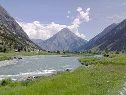
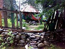
Gurez, or Gurais[1] (Guráai in the local Shina language),[2] is a valley located in the high Himalayas, about 86 kilometres (53 mi) from Bandipore and 123 kilometres (76 mi) from Srinagar in northern Kashmir and southern Gilgit-Baltistan. At about 8,000 feet (2,400 m) above sea level, the valley is surrounded by snow-capped mountains. It has diverse fauna and wildlife including the Himalayan brown bear and the snow leopard. The Kishanganga River flows through the valley.[3] The road to Gilgit runs through Gurez.
Gurez is divided into three regions. The area from Toabat to Sharda Peeth is administered by Pakistan as Neelum District, that between Kamri and Minimarg is administered by the Pakistan as Astore District, Gilgit-Baltistan, and that from Toabat to Abdullae Tulail is known as Gurez tehsil, and is part of the Indian-administered Bandipora district.
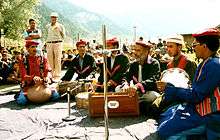
Being situated very close to the Burzil Pass, which leads into Astore District of Gilgit-Baltistan, the inhabitants are ethnic Dards/Shins. They speak the Shina language and have the same styles of dress and culture as their kinsmen in Pakistani- administered Northern areas.[4]
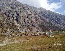
Dawar is the central township in the area. The population of the area is estimated to be about 30,000, and is scattered among fifteen villages. Due to heavy snowfall in winter, (approx. 6-7 fts)the valley remains cut off for six months of the year.
History
Historically, Gurez was part of ancient Dardistan, stretching between Sharada Peeth in the west, Minimarg in the north, Drass in the east, and Baghtor in the south. The valley falls along the ancient Silk Route, which connected the Kashmir Valley with Gilgit, before continuing further to Kashgar. Archaeological surveys in valleys north of Gurez have uncovered hundreds of carved inscriptions in Kharoshthi, Brahmi, and Tibetan. In particular, the carvings provide insights into the origins of the Kashmiri people and the early history of Buddhism.
The ancient capital of the Dards, Dawar, is located in the Gurez Valley and is an important archaeological site. Other archaeological sites of importance in the valley include Kanzilwan, where the last council of Buddhism is believed to have been held and, further downstream, the ruins of the ancient Sharada University are preserved along the Kishenganga/Neelum River.
Prior to the partition of Kashmir, Gurez had been a popular destination for foreign tourists, including Franklin Delano Roosevelt, who is known to have visited some time before he became the US president.[5] During the colonial period, Gurez was often visited by trekkers. Nehru and Indira Gandhi, accompanied by Sheikh Abdullah, were among those who visited the area in the 1940s, fishing for trout at Naranag, one of the lakes in the mountains above the valley.[6]
Geography
While describing the Kishenganga Valley (Gurez), Walter R. Lawrence writes in his book The Valley of Kashmir,
"Perhaps Pahalgam, the village of the shepherds that stands at the head of the Liddar valley with its healthy forest of pines, and Gurez, which lies at a distance of thirty-five miles from Bandipora, the port of the Wular Lake, will before long rival in popularity the other margs. Gurez is a lovely valley five miles in length lying at an elevation of about 8000 feet above the sea. The Kishenganga river flows through it, and on either side tower mountain scraps of indescribable grandeur. Perhaps one of the most beautiful scenes in the whole of the Kashmir is the grove of huge poplars through which the traveller enters the Gurez valley. The climate is dry and mild, excellent English vegetables can be grown, and the wild raspberries and currants are delicious."[7]
"The valley is extremely picturesque, as the river comes dashing along through a rich meadow, partly covered with lindens, walnut and willow trees, while the mountains on either side present nothing but a succession of most abrupt precipices, and Alpine lodges, covered with fir trees."[8]
Habba Khatoon
Gurez's most formidable peak is Habba Khatoon, around which legends abound and at one time, even a film starring Dimple Kapadia was planned.[9] This pyramid shaped peak was named after the Kashmiri poet Habba Khatoon. She was a beautiful and intelligent woman from Saffron village chandhara, and originally known as "Zoon" (which means Moon in English). She was the daughter of a peasant Abuddi Rather, who married her to an illiterate peasant boy named Habba. Zoon was ill-treated by her mother-in-law and husband, because she spent most of her time in poetry and singing. Dejected by her plight, she changed her name to Habba Khatoon.
The emperor of Kashmir, Yousuf Shah Chak, was enthralled by her beauty, intelligence and poetry. He arranged her divorce from Habba and married her. According to the story, Shah Chak was imprisoned by his rival King Akbar, Habba Khatoon used to wander near the peak that now bears her name to look for her lover. After her husband's death, she wandered the banks of river Jhelum in mourning. She died twenty years later by drowning into the jhelum and now her tomb is at Athwajan.[10] [11] Habba Khatoon Drama club was founded in 1976 by the poet Late Hajji Abdul Aziz Samoon (Retired Police Officer; SSP). The club played a pivotal role in safeguarding the cultural ethos and traditions of the Dard-Shin tribe. Hajji Abdul Aziz Samoon(KPS) was also Chairman of Jammu and Kashmir Dard-Shina Development Organization (JKDSDO), a body representing Dard community in the state JKDSDO [12] [13]
Economy
Energy
There is no central electricity in Gurez, although, as of 2009, a hydro-electric plant is under construction by the National Hydroelectric Power Corporation. It is unclear if any of the generated energy will be available to the valley itself.[14] India had initially planned to construct a 100-metre-high dam on the Kishenganga, which would have flooded the majority of the Gurez Valley and forced nearly all of its residents to relocate. But due to resistance by the Dard Shin and by Pakistan, which is constructing a dam downstream, the dam’s height has been reduced to 37 metres. Set for completion in 2016, the dam will divert water from the Kishenganga towards Wular Lake via a 20 kilometre concrete tunnel, and will generate electricity for the nearby region. Although construction of the dam will temporarily bring work and money into the area, the Dard Shin have expressed concern that around 130 families will still lose their homes, and more than 300 hectares (740 acres) of land in the valley will be submerged.[15]
Because of the lack of electricity, there is no significant industrial activity in the valley. The only electricity which is available comes from a few diesel generators which provide power to some parts of the area in summer for an hour at a time. The Indian government’s relocation plans are unclear, and it has not yet committed to providing hydroelectricity to those who will remain in the valley.[16]
Fishery
Kishenganga River, with a length of 150 kilometres (93 mi), supports world class trout with an average weight of 24 pounds (11 kg). As of 2006, there were plans to develop the fishery potential of the area, making it a resource for the surrounding region.
Fish in the river include:[17]
- Brown trout (Salmo trutta fario)
- Rainbow trout (Salmo gairdneri)
Religion
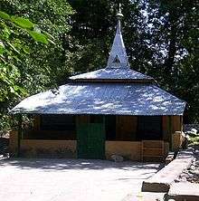
Gurez has an only Sunni Muslim gtpopulation. Before the arrival of Mir Sayyid Ali Hamadani, the region was predominantly Hindu. Hamadani visited the Kashmir valley three times, accompanied by about seven hundred preachers, known as "Sadaats". Of these seven hundred people, seven settled in Gurez and included Baba Abdur Razaq Shah and Baba Dervaish whose shrines are located near the hamlet of Fakirpora. The names of the other saints are unknown, although they also have shrines, located at Chorwan, Bagtore, Dangital Tulail across the Kishan Ganga River, and at Kamri across the border near Dood-Gagi village in Pakistan-administered Kashmir.[19]
Peer Baba
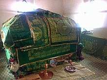
The Peer Baba came from Multan (Pakistan) in 1933 and established himself in a cave at Durmat, north of Kanzalwan. He was about 35 years old, and his religion is unknown. He is said to have fasted for months without taking any food or water. On occasion, he came down to Kanzalwan and asked for food in Farsi with an Urdu accent. He never refused mutton offered by local Muslims. He was hard of hearing, spoke very little and was popularly known as "Nanga Baba". In Feb 1940, he came down from Durmat to Rajdhan during a heavy snowstorm, and subsequently died. When the locals tried to bring the Baba’s body to Bandipur for burial, they were attacked by large number of honeybees, and he was instead buried close to Rajdhan Pass.
See also
References
- ↑ Spelt گُریز in Kashmiri and گورأى in Shina
- ↑ Schmidt, Ruth Laila; Kaul, Vijay Kumar (2008). "A comparative analysis of Shina and Kashmiri vocabularies". Acta Orientalia. 69: 231–303. In this orthography áa represent a long a with a high falling pitch.
- ↑ "A Journey to Kashmir's Gurez Valley".
- ↑ "Gurez an introduction". 4 January 2008. Archived from the original on 10 July 2009.
- ↑ "Hidden paradise". 6 December 2008.
- ↑ "GUREZ: KASHMIR: FIRST-HAND REPORT". 27 August 2007.
- ↑ (P: 16)
- ↑ Sir Charles Ellison Bates, 1872 AD
- ↑ "Gurez: Kashmir Untouched". 4 March 2002.
- ↑ Go to Kashmir. "About Gurez".
- ↑ Kashmir Images. "Shina conference".
- ↑ Greater Kashmir. "Shina Poet".
- ↑ kashmirimages. "Dard community alleges discrimination".
- ↑ "Electricity still a far-fetched dream for Gurez valley". 30 August 2009.
- ↑ "Dammed if you do". May 2010.
- ↑ "Dammed if you do". May 2010.
- ↑ "Gippsland Aquaculture Industry Network GAIN". 2 September 2006. Archived from the original on 20 February 2012.
- ↑ "Photos by Zahid Samoon". 16 January 2007.
- ↑ "Religion in Gurez". 14 June 2008. Archived from the original on 5 July 2009.
External links
| Wikimedia Commons has media related to Gurez. |