Leh–Manali Highway
| Leh-Manali Highway | |
|---|---|
|
लेह-मनाली राजमार्ग Leh-Manali rājamārg | |
 | |
| Route information | |
| Length | 479 km (298 mi) |
| Major junctions | |
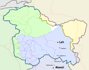
| North end | Leh, Ladakh, Jammu and Kashmir |
| South end | Manali, Himachal Pradesh |
| Location | |
| States | Himachal Pradesh, Jammu and Kashmir |
| Primary destinations | |
| Highway system | |
Coordinates: 32°14′58″N 77°11′26″E / 32.2495793°N 77.1905049°E
The Leh–Manali Highway (Hindi: लेह-मनाली राजमार्ग Leh-manali rājamarg) is a 490 km (300 mi) long highway in northernmost India connecting Leh in Ladakh in Jammu and Kashmir state and Manali in Himachal Pradesh state. It is open for only about four and a half months in a year in summer between May or June, when the snow is cleared, and mid-October when snowfall again blocks the high passes. It connects Manali valley to Lahaul and Spiti valleys and Zanskar valley in Ladakh.
Leh–Manali Highway was designed and built and is maintained entirely by the Border Roads Organisation (BRO) of Indian army. It is capable of supporting the heaviest of army vehicles.
Geographical features
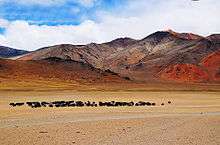
The average elevation of Leh-Manali highway is more than 4,000 m (13,000 feet)[1] and its highest elevation is 5,328 m (17,480 ft) at Tanglang La mountain pass. It is flanked by mountain ranges on both sides featuring some stunning sand and rock natural formations.

The highway crosses many small streams of ice-cold water from snow-capped mountains and glacial melts without a bridge and it requires driving skill to negotiate fast-flowing streams. The landscape changes immediately after getting past Rohtang Pass and entering into Chandra river valley in Lahaul region that lies in rain-shadow. The greenery on the southern side of the mountain pass disappears and the mountain slopes on the leeward side become brown and arid. However, the mountain peaks are covered in snow and shine brightly in sun.
Leh-Manali highway is generally two lanes wide (one lane in either direction) without a road-divider but has only one or one and a half lanes at some stretches. It has over a dozen bailey bridges and most of them are in dilapidated condition. The highway has many damaged stretches and under-maintenance portions where even a little rainfall can trigger landslide making it very dangerous to cross that stretch of the road. The riding quality is not good at many places and fast speeds can cause discomfort.
Length of highway
The total length of the highway is about 490 km (300 mi). The distance in Himachal Pradesh state between Manali and Sarchu is 230 km (140 mi)[2] and the distance in Ladakh region from Sarchu to Leh is 260 km (160 mi). The length in Himachal Pradesh state will reduce by about 46 km (29 mi) when Rohtang Tunnel is commissioned in 2019 obviating the need to climb to Rohtang Pass.
At Sarchu, Lahaul region ends at the Himachal Pradesh state border and Zanskar region starts in Ladakh region of Jammu and Kashmir state.
Route
Manali – Rohtang Jot - Gramphu - Kokhsar - Tandi - Keylong - Jispa - Darcha – Zingzingbar - Baralacha La - Bharatpur - Sarchu (state border) - Gata Loops - Nakee La - Lachulung La - Pang - More Plains - Tanglang La - Gya - Upshi - Karu - Leh
Distances
- 1: Manali (altitude 1,950 m (6,400 ft)) to Marhi at 3,300 m (10,800 ft) elevation 33 km (21 mi). It is a steady climb. Good roads
- 2: Marhi to Rohtang Pass at 3,980 m (13,060 ft) elevation 18 km (11 mi). It is a steady climb.
- 3: Rohtang to Gramphu at 3,200 m (10,500 ft) elevation 19 km (12 mi). It is a steady descent. Turn left (towards west) at Gramphu on the highway along Chandra river to proceed towards Leh. The right turn (towards east) at Gramphu leads to Spiti valley and Batal, Kunzum La and Kaza on a road along Chandra river that is paved for some distance and then unpaved. Decent roads
- 4: Gramphu to Kokhsar, the first village north of Rohtang Pass.6 km (3.7 mi).
Foreign nationals have to show their passports with valid visa at the police check post here. (Anyone can visit Leh freely. However, special permission is needed to visit some restricted areas beyond Leh. This permit can be obtained at Leh.) pure offroad
- 5: Kokhsar to Sissu at 3,130 m (10,270 ft) elevation 25 km (16 mi). There is a helipad at Sissu. The highway runs along left (south) bank of Chandra River. Brilliant roads
- 6: Sissu to Tandi at 2,570 m (8,430 ft) elevation 8 km (5.0 mi). Tandi is situated at the bottom of the river valley at the confluence of the Chandra river and the Bhaga river (flowing down from north) which merge to form the Chandra-Bhaga river (that later becomes known as Chenab downstream in Jammu and Kashmir). Cross the Bhaga river over the bridge towards the right, take the right turn at the fork and the road again starts climbing. Good road except for a 1 km stretch of offroad.
- 7: Tandi to Keylong at 3,080 m (10,100 ft) elevation 9 km (5.6 mi). Good road
- 8: Keylong to Jispa at 3,310 m (10,860 ft) elevation 22 km (14 mi). Good road
- 9: Jispa to Darcha at 3,360 m (11,020 ft) elevation 6 km (3.7 mi). All tourists have to register at the police check post here. Mixed road offroad and decent road
- 10: Darcha to Zingzingbar 4,270 m (14,010 ft) elevation 26 km (16 mi). The steep ascent to Baralacha La starts at Zingzingbar. Mixed road
- 11: Zingzingbar to Baralacha La pass at 5,030 m (16,500 ft) elevation 18 km (11 mi). It is a steady climb. (Both the Bhaga river and the Chandra river originate from melting snow at opposite sides of Baralacha La, the former flowing southwest and the latter flowing first southeast and then northwest to merge at Tandi.) offroad
- 12: Baralacha La to Bharatpur 2 km (1.2 mi). It is a steady descent. Offroad
- 13: Bharatpur to Sarchu at 4,300 m (14,100 ft) elevation 38 km (24 mi). Sarchu is a military base and has a police check post. Register at the police check post here. (Himachal Pradesh state ends here. Ladakh region of Jammu and Kashmir state starts here.) offroad.
- 14: Sarchu to Pang 4,600 m (15,100 ft) elevation 80 km (50 mi) climbing 500 m through the Gata loops (22 hairpin bends) at 4,190 m (13,750 ft) elevation and traversing through Nakee La pass at 4,739 m (15,547 ft) and Lachulung La pass at 5,065 m (16,616 ft) elevations. Register at the check post at Pang. offroad
- 15: Pang to Tanglang La pass at 5,328 metres (17,480 ft) elevation, 69 km (43 mi) through a 4,700 m (15,400 ft) plateau called More plains or Morey plains.
- 16: Tanglang La pass to Upshi 60 km (37 mi). Upshi has a Customs and Excise taxation check post before crossing the river. Stop here for checking of vehicles. Then cross Indus river to reach Upshi village on the right bank (north) of the river. An ancient trading road (right turn while coming from Manali and going to Leh) heads to the east from Upshi towards Tibet. There is a helipad on this road. Brilliant roads
- 17: Upshi to Karu 16 km (9.9 mi) After crossing Indus river, the highway is on the right bank (north) of the river from Upshi to Leh. Turn left at Upshi for Karu. Do not take the right turn that leads to the east towards Tibet. Good road
- 18: Karu to Leh at 3,500 metres (11,483 ft) elevation, 35 km (22 mi) Continue on the highway towards Leh. Do not take the right turn just before Karu that leads to Shyok. Good road
The distance from Lachalang La pass to the Tanglang La pass is 87 km (54 mi) via Pang.
Travel time
The journey from Manali to Leh normally takes at least two days if done in a rush, or more days depending on the condition of the road and vehicle. Tourists and travellers make overnight stops at Jispa and tented camps such as Sarchu. Alternately, overnight stops can be made at Keylong town.
However, travel time is unpredictable due to uncertainties of weather that can turn inclement any time and play spoilsport, and poor condition of the road. The Leh-Manali highway consists of generally bad stretches of roads, snow crossings, water crossings due to glacial melts and occasional landslides. It transverses high passes at over 5,000 metres.
The peak travel season is during May and June when a lot of tourists visit Rohtang pass. Most of the domestic tourists return to Manali and do not cross Rohtang pass towards north. Much of Rohtang pass remains covered by snow even during summer. Public buses start from Manali towards Keylong and onwards early at 4 am and after every two hours or so until 12 noon. The noon bus is the last one. The time taken until Keylong is 4 to 10 hours depending upon the condition of the road (that sometimes turns into a slush or becomes too slippery to travel because of fresh snowfall or melting of snow) and traffic jam that occurs at Beas Nallah near Marhi and then at Rohtang pass. It is advisable to cross Rohtang pass before 8 am. Private four-wheel drive taxi are available. Share taxi are cheap as they charge per person but should be avoided by tourists as they are overcrowded with local residents and do not allow a good view of the outside. The fun in the journey is lost while travelling cramped in share taxi. Moreover, they cannot be stopped at will at any place. Some tourists travel from Manali to Leh and other places in Ladakh on motorcycles, generally in a group.
Fuel stations It is to be noted that there is a scarcity of fuel pumps along this route and the last fuel station is in Tandi and thereafter there are no fuel pumps for another 365 km until Leh. When travelling from Manali, it is advisable to fuel up at Tandi fuel pump and carry additional fuel in cans, especially for motorcycles and small vehicles with limited petrol tank capacity. Similarly, while travelling from Leh towards Manali, people fuel up to the brim at Leh and carry additional provisions. In case of emergencies, the fuel may be available with local settlement enroute at Sarchu, Pang etc. but this fuel may be adulterated and should be used with caution.
Altitude sickness
Owing to the rarefied atmosphere (low air pressure) at high altitude, less oxygen is breathed in and many travellers experience altitude sickness or acute mountain sickness. Before beginning the journey on the highway towards Leh, it is advisable to stay at the starting point Manali (altitude 1,950 m (6,400 ft)) one night and again minimum one night at either Keylong, Jispa or Darcha to cope with the high passes and plains after Darcha. It is strongly advised not to sleep in Sarchu or Pang on the upward journey (towards Leh) as it can cause acute mountain sickness: headache, nausea, dizziness and vomiting. There have been deaths from AMS as well. The safe option is to camp at Leh or higher altitude after getting acclimated to lower oxygen levels. It is also advisable to carry chocolates, glucose or other high energy food on the journey and spend only a little time at the high mountain passes.
Climate along the highway
Ladakh is a cold semi-arid desert. It is cold along the highway even in summer (June onwards); the days are warm in bright sunshine but the nights are very cold. The water from glacial melts is ice-cold and one should avoid getting wet in water-crossings on the highway. Light woollens are required during the day and thick woollens are required at night. There is no rainfall between Rohtang pass and Leh even during the monsoon season in July–September as the entire region lies in rain-shadow. The greenery on the southern side of Rohtang disappears and the mountain slopes on the northern side become brown and arid. However, the mountain peaks are covered in snow and glare brightly in sun.
Accommodation along the highway
In India, a dhaba is a road-side eatery with low prices and no frills. It is not a motel. Such dhabas or eateries are found at some otherwise uninhabited places along the highway. Dhabas generally allow drivers to lie down and rest for a while. An occasional dhaba may provide a dormitory bed (without any associated facility) to a tourist at a low price.
- Manali city has many hotels to suit all budgets.
- Kokhsar village has only one guesthouse.
- Sissu has a hotel and PWD rest house. Sissu has a beautiful waterfall on the other side of river Chandra. Sissu has a helipad for helicopter service from Manali during winter.
- Tandi village is situated at the confluence of the Chandra river (flowing down from north) and Bhaga river (flowing from south and east), which merge to form the Chandra-Bhaga river that is known as Chenab River downstream.
- Keylong town is district headquarters and has proper hotels including an HPTDC (tourism development corporation) hotel and PWD rest house.
- Jispa village at the junction of two nullahs (small streams) with Bhaga river has one luxury hotel, a guest house and tented accommodation (Swiss cottage tents and standard tents).
- Darcha has temporary tented accommodation run by some local residents.
- The steep ascent to Baralacha La (elevation 5,030 m (16,500 ft)) starts at Zingzingbar (elevation 4,270 m (14,010 ft)). There is a stream (from a glacial melt) flowing across the highway just after Zingzingbar. It is advisable to cross the stream before noon because the flow of ice-cold water increases as the day temperature rises. If the flow of water in the stream is too powerful for a vehicle to cross it or if the weather turns ugly en route to Baralacha La, turn back to Zingzingbar where dhaba tent basic accommodation is available quite cheaply. Or one can go back to Darcha.
- There are a few tents at Bharatpur (after descending from Baralacha La pass) which offer only basic accommodation. Bharatpur is not a village; it is set up only for tourists during tourist season and is a collection of tents.
- Sarchu has only tents but with quite a few choices from cheap accommodation in Dhaba tents which cost Rs.60 (1 US$) per person to luxury tents (Swiss cottage tents) costing thousands of rupees a night.
- Pang has tented accommodation available, although choices at Pang are less than the choices in Sarchu.
- Upshi has a few guest houses along the Leh-Manali highway. Upshi is reached after crossing Indus river. It has a Customs and Excise taxation check post before crossing the river and a helipad after crossing the river. An ancient trading road heads to the east from Upshi towards Tibet.
- Karu has guest houses.
- Leh is the capital and tourist hub of Ladakh and has many accommodation options to suit all budgets.[3]
Gallery
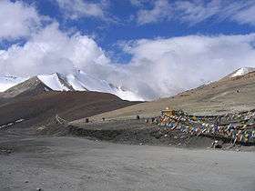 Tanglang La pass at 5,360 m (17,585 ft) elevation on Leh–Manali Highway
 Stone shrine at Baralacha La pass
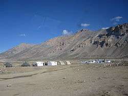 Row of Tents at Sarchu
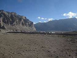 Tented accommodation at Sarchu
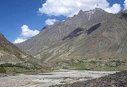 Darcha village on the bank of Bhaga river
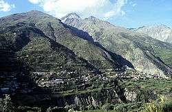 Keylong, viewed from Kardang Monastery
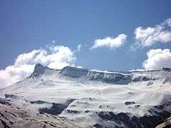 A panoramic view of distant Himalayan peaks from Rohtang Pass, May 2009
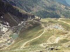 A view of Dhaba (road-side eatery) and Leh–Manali Highway on the way to Rohtang Pass, May 2009
 Rohtang Pass becomes impassable during winter
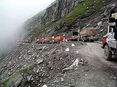 Traffic jam on Rohtang Pass, 2004.
 Mountains near Rohtang Pass
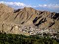 A panoramic view of Leh
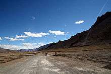 Straight stretches of road on More Plains
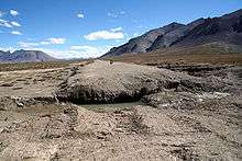 Road eroded by fast-flowing water stream on More Plains
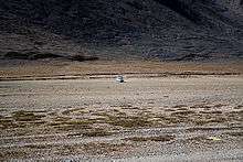 A four-wheel drive vehicle taken with a 300 mm telephoto lens shows the vast expanse of More plains and the size of the mountains that flank it
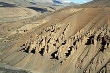 Natural Rock and Sand Formations along Sumkhel Lungpa River in More Plains
 Natural Rock and Sand Formations along Sumkhel Lungpa River in More Plains
.jpg) The village of Upshi and road junction at the northern end of the Leh Manali Highway
The village of Upshi and road junction at the northern end of the Leh Manali Highway
See also
References
External links
| Wikimedia Commons has media related to Leh–Manali Highway. |
- Mountain Passes along the route
- Riding on the Manali-Leh route
- high road to... Manali-Leh & Srinagar-Leh updates
- Leh-Manali Highway
- Manali-Leh Highway on Bikemap (with GPS-track)
- Photos of a bike tour along the Highway from 1996.
- Ladakh detailed map
- U.S. Army Map Service
- Manali to leh motorcycle tour map
