Wakura
| Wakura | |
|---|---|
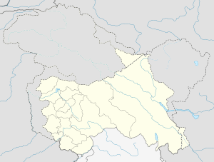
 Wakura Location in Jammu and Kashmir, India  Wakura Wakura (India) | |
| Coordinates: 34°05′N 74°47′E / 34.09°N 74.79°ECoordinates: 34°05′N 74°47′E / 34.09°N 74.79°E | |
| District | Ganderbal district |
| Settled | Ancient |
| Elevation | 1,619 m (5,312 ft) |
| Languages | |
| • Official | Urdu |
| Time zone | UTC+5:30 (IST) |
| PIN | 191131 |
| Distance from Delhi | 858.9 kilometres (533.7 mi)[1] |
| Distance from Mumbai | 2,206.7 kilometres (1,371.2 mi)[2] |
Wakura is the village Ganderbal district, Jammu and Kashmir. It is one of the four blocks of District Ganderbal, others being Lar, Kangan and Ganderbal respectively.
Geography
Wakura is located 34°05′N 74°47′E / 34.09°N 74.79°E 7 km towards west from District headquarters in Ganderbal, 20 km from State capital Srinagar. The Wakura is next to dab village which is located along the river Jhelum (symbol) shadipora . The tehsil is bounded by Lar towards North, Ganderbal towards East, Narbal towards South and Hajin towards North.[3]
Demographics
The Thesil Wakura has the population of 5625. Males constitute 51% of the total population while female constitute 49% of the total population. Urdu is the official language here, people also speak their native language (Kashmiri) as well as English.[4]
Reduced Level
The Reduced Level of the area is 1619 m above mean sea level.[5]
Education
- Baby's Land Public High School Wakura.
- Govt boys higher secondary school wakura.
- Girls secondary school Wakura
- saadat valley school
- primary school kumarmohalla
See also
References
- ↑ "Distance between Wakura and New Delhi". Retrieved 27 November 2014.
- ↑ "Distance between Wakura and Mumbai". Retrieved 27 November 2014.
- ↑ "Coordinates of Wakura, Ganderbal". Retrieved 27 November 2014.
- ↑ "Population of Wakura". Retrieved 27 November 2014.
- ↑ "Reduced level of Ganderbal district". Retrieved 27 November 2014.