Samba district
| Samba district साम्बा, سامبا | |
|---|---|
| District of Jammu and Kashmir | |
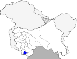 Location of Samba district in Jammu and Kashmir | |
| Country | India |
| State | Jammu and Kashmir |
| Administrative division | Jammu Division |
| Headquarters | Samba, Jammu and Kashmir |
| Tehsils | Samba |
| Area | |
| • Total | 1,002 km2 (387 sq mi) |
| Population (2011) | |
| • Total | 3,18,898 |
| • Density | 320/km2 (820/sq mi) |
| • Urban | 16.8% |
| Demographics | |
| • Literacy | 81.41% |
| • Sex ratio | 886 |
| Vehicle registration | JK-21 |
| Coordinates | 32°33′N 75°07′E / 32.550°N 75.117°ECoordinates: 32°33′N 75°07′E / 32.550°N 75.117°E |
| Website | Official website |
Samba District is a newly formed district in the Indian administered state of Jammu and Kashmir. Before the formation of this district, the area now under the district was part of Jammu district. Now the district itself covers Samba town and adjoining tehsils namely, Vijaypur and village Supwal, Gahwal. Historically Samba consist of 22 native towns (also known as Mandi), each consist of a separate family. The district is separated from the Jammu district by "Purmandal Bridge". Muslims make up just under 6% of total population according to 2001 India census.Samba town is situated on the stream Basantar River.
History
Prior to 1947, Samba was a tehsil in the Jammu district.[1]
Administration
Samba district consists of four blocks: Samba, Vijay Pur, Purmandal, and Ghagwal.[2] Each block consists of a number of GREF panchayats. The biggest village is Rajpura.
Politics
Samba District has two assembly constituencies: Samba and Vijaypur.[3] Both the assembly constituencies are part of Jammu (Lok Sabha constituency).[4]
Demographics
According to the 2011 census Samba District has a population of 318,611,[5] roughly equal to the nation of The Bahamas.[6] This gives it a ranking of 568th in India (out of a total of 640).[5] The district has a population density of 318 inhabitants per square kilometre (820/sq mi) .[5] Its population growth rate over the decade of 2001 to 2011 was 16.9%.[5] Samba has a sex ratio of 886 females for every 1,000 males,[5] and a literacy rate of 82.48%.[5]
Religion
Hindu 86.33%, Muslim 7.20%, Sikh 5.63%, Christian 0.72%, Buddhist 0.02%, Jain 0.01%, Not stated 0.09% as at 2011 census.[7]
References
- ↑ Snedden, Christopher (2015), Understanding Kashmir and Kashmiris, Oxford University Press, p. xxi, ISBN 978-1-84904-342-7
- ↑ Statement showing the number of blocks in respect of 22 Districts of Jammu and Kashmir State including newly Created Districts Archived 10 September 2008 at the Wayback Machine. dated 2008-03-13, accessed 2008-08-30
- ↑ "ERO's and AERO's". Chief Electoral Officer, Jammu and Kashmir. Archived from the original on 22 October 2008. Retrieved 28 August 2008.
- ↑ "Assembly Constituencies - Corresponding Districts and Parliamentary Constituencies of Jammu and Kashmir". Chief Electoral Officer, Jammu and Kashmir. Archived from the original on 31 December 2008. Retrieved 30 October 2008.
- 1 2 3 4 5 6 "District Census 2011". Census2011.co.in. 2011. Retrieved 2011-09-30.
- ↑ US Directorate of Intelligence. "Country Comparison:Population". Retrieved 2011-10-01.
Bahamas, The 313,312
- ↑ http://www.census2011.co.in/data/religion/district/640-samba.html Census 2011, Samba district
Places adjacent to Samba district | ||||||||||
|---|---|---|---|---|---|---|---|---|---|---|
| ||||||||||