Doda district
| Doda district | |
|---|---|
| District of Jammu and Kashmir | |
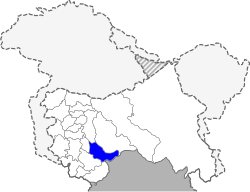 Location of Doda district in Jammu and Kashmir | |
| Country | India |
| State | Jammu and Kashmir |
| Administrative division | Jammu Division |
| Headquarters | Doda |
| Tehsils |
1. Bhaderwah 2. Doda 3. Gondoh 4. Thathri [1] |
| Area | |
| • Total | 2,625 km2 (1,014 sq mi) |
| Population (2011) | |
| • Total | 409,936 |
| • Density | 160/km2 (400/sq mi) |
| Demographics | |
| • Literacy | 64.68% |
| • Sex ratio | 919 |
| Vehicle registration | JK-06 |
| Major highways | NH 244 |
| Coordinates | 33°08′45″N 75°32′52″E / 33.145733°N 75.547817°ECoordinates: 33°08′45″N 75°32′52″E / 33.145733°N 75.547817°E |
| Website | Official website |

Doda is a district in eastern part of Jammu Division of the Indian state of Jammu and Kashmir. The district consists of 8 Tehsils: Bhagwa, Assar, Doda, Gundana, Marmat, Bhaderwah, Gandoh (Bhalessa), and Thathri.[2]
History
The Doda district consists of areas drawn from the ancient principalities of Kishtwar and Bhadarwah, both of which were part of a district by the name of 'Udhampur' in the princely state of Jammu and Kashmir.[3]
In 1948, the erstwhile Udhampur district was partitioned into the present Udhampur district, containing the Udhampur and Ramanagar tehsils, and a 'Doda' district containing the Ramban, Bhadarwah and Kishtwar tehsils.[4][5][6]
In 2006, Ramban was made into an independent district and the hilly area to the east of the present Doda district was separated as the Kishtwar district. The remaining areas include the Doda tehsil carved out of Kistwar and the original Bhadarwah, now divided into three tehsils.[4][7]
Demographics
According to the 2011 census Doda district has a population of 409,936,[8] roughly equal to the nation of Malta.[9] This gives it a ranking of 556th in India (out of a total of 640).[8] The district has a population density of 79 inhabitants per square kilometre (200/sq mi) .[8] Its population growth rate over the decade 2001-2011 was 27.89%.[8] Doda has a sex ratio of 922 females for every 1000 males,[8] and a literacy rate of 65.97%.[8] The district has a Muslim majority 53.82%, with Hindus constituting 45.94% of the population and the remainder consisting of Christians, Sikhs, Buddhists and Jains.[10]
Languages
Scholar Sumantra Bose states that the majority of Doda Muslims are Kashmiri-speaking.[11] A study conducted in 2014 identified 40% of the population as Kashmiri-speaking.[12] A section of population also speaks a dialect named Sarazi.
Vernaculars include Bhadrawahi, a Western Pahari dialect spoken by about 53 000 people in Doda district, written in both the Arabic and Devanagari scripts.[13]
Administration
Administratively, the district with 406 villages, three being un-inhabited. Doda District has been divided into three subdivisions viz., Doda, Bhaderwah and Bhalessa(Gandoh) . It has twelve tehsils.[14] There are eight Rural Development Blocks comprising Bhaderwah, Ghat(Doda), Thathri, Gandoh, Bhagwah, Assar, Marmat and Gundana. The number of Panchyats is 232.[15]
Politics
Doda District has two assembly constituencies: Bhaderwah and Doda.[16]
References
- ↑ "Tehsils in Doda district, Jammu and Kashmir - Census 2011".
- ↑ Statement showing the number of blocks in respect of 22 Districts of Jammu and Kashmir State including newly Created Districts Archived 10 September 2008 at the Wayback Machine. dated 2008-03-13, accessed 2008-08-30
- ↑ "About Doda District". Jammu Redefining. Archived from the original on 2016-03-17.
- 1 2 District profile, Krishi Vigyan Kendra, Doda, retrieved 23 October 2016.
- ↑ Snedden, Christopher (2015), Understanding Kashmir and Kashmiris, Oxford University Press, p. xxi, ISBN 978-1-84904-342-7
- ↑ Behera, Navnita Chadha (2007), Demystifying Kashmir, Pearson Education India, p. 28, ISBN 8131708462
- ↑ 8 New Districts in JK, 13 New Tehsils, Greater Kashmir, 7 July 2006.
- 1 2 3 4 5 6 "District Census 2011". Census2011.co.in. 2011. Retrieved 2011-09-30.
- ↑ US Directorate of Intelligence. "Country Comparison:Population". Retrieved 2011-10-01.
Malta 408,333 July 2011 est.
- ↑ District Census Handbook: Doda, Directorate of Census Operations, Jammu & Kashmir, 2017.
- ↑ Sumantra Bose, Geography, Politics and the Fighters of Kashmir Archived 16 December 2011 at the Wayback Machine. London School of Economics
- ↑ Shujaat Bukhari, Nearly 35% People Speak Kashmiri In Erstwhile J&K: Study, Rising Kashmir, 29 June 2014.
- ↑ M. Paul Lewis, ed. (2009). "Bhadrawahi: A language of Pakistan". Ethnologue: Languages of the World (16th ed.). Dallas, Texas: SIL International. Retrieved 2011-09-28.
- ↑ Creation of new Administrative Units in the State, Government of Jammu and Kashmir, 16 July 2014.
- ↑ "Official webportal of Doda district". NIC Doda. Retrieved 2013-03-30.
- ↑ "ERO's and AERO's". Chief Electoral Officer, Jammu and Kashmir. Archived from the original on 2008-10-22. Retrieved 2008-08-28.
Further reading
- Qazi, S.A. (2005), "Part II: Doda district", Systematic Geography of Jammu and Kashmir, APH Publishing, pp. 210-, ISBN 978-81-7648-786-3
External links
Places adjacent to Doda district | |
|---|---|