Kishtwar
| Kishtwar کشتواڑ | |
|---|---|
| City | |
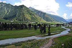 Warwan valley | |
 Kishtwar Location in Jammu and Kashmir, India  Kishtwar Kishtwar (India) | |
| Coordinates: 33°19′N 75°46′E / 33.32°N 75.77°ECoordinates: 33°19′N 75°46′E / 33.32°N 75.77°E | |
| Country |
|
| State |
|
| District | Kishtwar |
| Elevation | 1,638 m (5,374 ft) |
| Population (2011) | |
| • Total | 14,865 |
| Languages | |
| • Official | Urdu |
| • Spoken | Kashmiri by Muslims and Kishtawari by local Hindus |
| Time zone | UTC+5:30 (IST) |
| Vehicle registration | JK17 |
| Website |
www |
Kishtwar is a municipality in the Kishtwar District of the Jammu region in the Indian state of Jammu and Kashmir.[1]
History
Kishtwar is first referred to in the Rajatarangini by the ancient name Kashthavata.[2][3] during the reign of Raja Kalsa of Kashmir (1063–1089), when "Uttamaraja", the ruler of Kashthavata visited the court of the Kashmir King in company with several other hill chiefs to pay their respects to the Raja.
Kishtwar merged with the State of Jammu and Kashmir in 1821, A.D. With the passage of time Kishtwar became a Tehsil of the Udhampur district and remained so until 1948, when it became part of the newly created District Doda in the wake of first re-organization of the state during the post-independence period.
Economy
The economy of area is not regularized with no visible investment from government. The area being rural in nature has agriculture based economy. The Padder area produces world class Pine nuts called chilgoza which is a delicacy and costly dry fruit. In Marwah, Chatroo, Mughalmaidan and Bounjwah Tehsils wall nut production of best quality walnuts in thousands of tons is recorded but due to absence of any fruit Mandi the exact figures are not available. Besides walnut, Marwah Tehsil produces thousands of tons of kidney beans which is the cash crop of the area. Villages of Pochhal, Matta and Hidyal produce saffron of good quality. The rural households are also abundantly gifted by nature through cash crops of eatable mushrooms and morchella called guchhi in local language. Some families have been reported to earn more than Rs1,00,000 per year by just selling the dried morchella in local markets. The eatable ferns are also a natural cash crop of the area. The apples are produced in some areas however the quality of Kishtwar apple is not of world class. Due to dry nature of the climate the village peasant population usually grow wheat and barley in Rabi season and kidney bean and maize in Kharif season. The rivers are rich source of electricity and the site of the hydroelectric power projects of Dul Hasti 390 MW, Ratle Hydroelectric Project 850 MW, Kirthai 1400 MW, Pakal Dool 1,000 MW, Lower Kalnai 48 MW and Chaudhary 15MW, Keeru HEPP and Kwar HEPP with the highest per capita wattage production in world for such a small area.These projects have been the largest source of employment and have immensely contributed to the prosperity of the area. Kishtwar has the distinction of producing world class blue Diamond Sapphire and its Kashmir sapphire was mined at Padder valley. The area is although rich in natural mineral resources but poor infrastructure has posed difficulty in its extraction. Mineral gypsum is mined at Village Trigam. The river sand of Chenab is of best quality and used extensively for construction purpose.
Demographics
As of 2011 India census Kishtwar had a population of 14,865. Males constitute 63% of the population and females 37%. Kishtwar has an average literacy rate of 78%, higher than the Indian national average: male literacy is 82%, and female literacy is 42%. In Kishtwar, 11% of the population is under six years of age. The main language spoken here by the Muslims is [[Kashmiri]] and local Hindus of Kishtwar speak a local dialect of Kashmiri language called [[Kashtwari]].[5] The dominant religion in Kishtwar is Islam with 69.21% population Muslims following Hinduism with second largest religion with 29.59% as Hindus.
Tourism
The Chenab River flows through the district and is joined by tributaries such as Marvisudar ruver of Mawah, Fambar Nallah, Chingam Nallah which meet at the confluence near Bhandarkoot. The rivers have cut steep gorges and wide plains on the way. Warwan valley and Marwah valleys are unique in being located in the way of river Marusudhar. The area is also known for its high mountain passes which have been the mountaineer's delight since British era. Many illustrations are found in the travelogue written by British writers including Otto Rothfield's With pen and Rifle in Kashmir. The Kishtwar Anantnag National Highway passes through the Synthan Pass and Daksum Nowpachi Road passes through the Margan top a 13 km long and 5100-metre-high pass. The Steep Brahma mountain peak is situated at Dachhan which is documented by British mountaineers. The Warwan Valley has been rated among India's top ten trekking destination with a wide range of landscape. Saffron of purest quality is produced in the iron rich soil at Pochhal, Matta, Lachdayaram and Hidyal. Kishtwar National Park, in the northeast region of the district, has a large number of peaks and glaciers. The town has a small Air Landing ground under the control and management of Indian Army which caters to civil and military Helicopters. The 33 hectare Chowgan is the largest natural ground located in the center of city and is used as a venue of recreation and religious and political gatherings. Mini Secretariat housing all the offices of Kishtwar District Administration besides world class Conference Hall is located 3 km from the main bus stand in Kuleed area. Kishtwar is endowed with dense forests of deodar, pine and fir. There are high altitude mountains ranging between 20,000 feet to 21,000 feet like Nun Kun, Burmah and Barnag.
References
- ↑ "District Kishtwar".
- ↑ "Kishtewar".
- ↑ Development Institute, MSME. "Brief Industrial Profile of Kishatwar District" (PDF).
- ↑ "Kishtwar District Religion Census 2011". 2011-01-01.
- ↑ Kashmiri, Ethnologue, retrieved 14 July 2018.
|