List of districts in Jammu and Kashmir
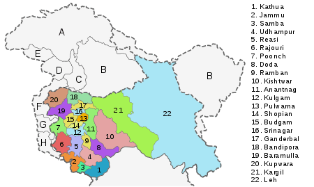
The Indian state of Kashmir consists of three divisions: Jammu, Kashmir Valley and Ladakh, and is further divided into 22 districts:[1] This excludes Gilgit-bultistan 64,817 and Pakistan administered Kashmir 13,297 km2 Total 78,114 km2 under the administration of Pakistan, 5,180 km2 handed over by Pakistan to China and 37,555 km2 Total 42,735 km2 under the administration of China in Ladakh district That is 2,22,236-1,20,849=1,01,387 km2 under India.[2]
History
Princely state of Kashmir
Prior to 1947, Kashmir was a princely state under the paramountcy of the British Indian Empire. The central part of the state was administratively divided into the provinces Jammu and Kashmir. In addition there were frontier districts and semi-autonomous jagirs (principalities). They were subdivided as follows:[3]
- Kashmir province: Districts of Srinagar, Anantnag, Baramulla and Muzaffarabad.
- Internal jagirs: Poonch, Chenani and Bhaderwah
- Jammu province: Districts of Jammu, Udhampur and Mirpur.
- Frontier districts:
The Gilgit district and the frontier ilaqa were administered by the British administration as the Gilgit Agency, which were returned to the princely state prior to the Partition of India.
Partition
Following the independence of India and Pakistan, in October 1947, there was a rebellion in the western districts of the state coupled with a tribal invasion, both of which were supported by the newly independent Dominion of Pakistan. The princely ruler acceded to the Indian Union in return for armed assistance. India and Pakistan fought the First Kashmir War that lasted through 1948, at the end of which large parts of the three western districts of Mirpur, Poonch and Muzaffarabad, the whole of the Gilgit Agency and the Skardu sub-district of Ladakh came under Pakistani control. The remainder of the princely state has been organised as a semi-autonomous state of the Indian Union under the name Kashmir.
Inside India
The territory under the state control include:[4][5]
- Kashmir Division: Kashmir South (Anantnag) and Kashmir North (Baramulla); 13 per cent of the Muzaffarabad district.[6]
- Ladakh Division: Kargil and Leh districts.
- Jammu Division: districts of Jammu, Kathua, Udhampur, Reasi; the jagirs of Chenani and Bhaderwah; 11 per cent of the Mirpur district and 40 per cent of the Poonch jagir.[6]
The districts were reorganised by 1968, breaking up some of the larger districts.[7] In 2006, eight new districts were created: Kishtwar, Ramban, Reasi, Samba, Bandipora, Ganderbal, Kulgam and Shopian.[8]
Districts
Jammu division
| Name of District | Headquarters | Area (km²) | Population 2001 Census | Population 2011 Census[9][10] |
|---|---|---|---|---|
| Doda District | Doda | 2,306 | 320,256 | 409,576 |
| Jammu District | Jammu | 3,097 | 1,343,756 | 1,526,406 |
| Kathua District | Kathua | 2,651 | 550,084 | 615,711 |
| Kishtwar District | Kishtwar | 7,737[11] | 190,843 | 231,037 |
| Poonch District | Poonch | 1,674 | 372,613 | 476,820 |
| Rajouri District | Rajouri | 2,630 | 483,284 | 619,266 |
| Ramban District | Ramban | 1,329 | 180,830 | 283,313 |
| Reasi District | Reasi | 1,719 | 268,441 | 314,714 |
| Samba District | Samba | 904 | 245,016 | 318,611 |
| Udhampur District | Udhampur | 4,550 | 475,068 | 555,357 |
| Total | 10 | 26,293 | 4,430,191 | 5,350,811 |
Kashmir valley division
| Name of District | Headquarters | Area (km²) | Population 2001 Census | Population 2011 Census |
|---|---|---|---|---|
| Anantnag District | Anantnag | 3,984 | 734,549 | 1,069,749 |
| Bandipora District | Bandipora | 398 | 316,436 | 385,099 |
| Baramulla district | Baramulla | 4,588 | 853,344 | 1,015,503 |
| Budgam District | Budgam | 1,371 | 629,309 | 755,331 |
| Ganderbal District | Ganderbal | 259 | 211,899 | 297,003 |
| Kulgam District | Kulgam | 1,067 | 437,885 | 423,181 |
| Kupwara District | Kupwara | 2,379 | 650,393 | 875,564 |
| Pulwama District | Pulwama | 1,398 | 441,275 | 570,060 |
| Shopian District | Shopian | 612.87 | 211,332 | 265,960 |
| Srinagar District | Srinagar | 2,228 | 990,548 | 1,250,173 |
| Total | 10 | 15,948 | 5,476,970 | 6,907,623 |
Ladakh division
| Name of District | Headquarters | Area (km²) | Population 2001 Census | Population 2011 Census |
|---|---|---|---|---|
| Kargil District | Kargil | 14,036 | 119,307 | 143,388 |
| Leh District | Leh | 45,110 | 117,232 | 147,104 |
| Total | 2 | 59,146 | 236,539 | 290,492 |
References
- ↑ "Department of Jammu & Kashmir Affairs". Government of India, Ministry of Home Affairs. Archived from the original on 8 December 2008.
- ↑ "Jammu & Kashmir profile" (PDF). Censusinfo India 2011. Retrieved 10 November 2016.
- ↑ Karim, Kashmir The Troubled Frontiers 2013, p. 31.
- ↑ Karim, Kashmir The Troubled Frontiers 2013, p. 29–32.
- ↑ Behera, Demystifying Kashmir 2007, p. 15.
- 1 2 Snedden, Understanding Kashmir and Kashmiris 2015, p. 167.
- ↑ Behera, Demystifying Kashmir 2007, p. 28.
- ↑ Jammu and Kashmir to have eight new districts, Indo-Asian News Service, 6 July 2006.
- ↑ 2011 census J&K
- ↑ "Department of Jammu & Kashmir Affairs". Government of India, Ministry of Home Affairs. Retrieved 10 November 2016.
- ↑ http://kishtwar.nic.in/districtstats.html
Bibliography
- Behera, Navnita Chadha (2007), Demystifying Kashmir, Pearson Education India, ISBN 8131708462
- Karim, Maj Gen Afsir (2013), Kashmir The Troubled Frontiers, Lancer Publishers LLC, pp. 30–, ISBN 978-1-935501-76-3
- Snedden, Christopher (2015), Understanding Kashmir and Kashmiris, Oxford University Press, ISBN 978-1-84904-342-7
External links
| Wikimedia Commons has media related to Districts of Jammu and Kashmir. |
| States | ||
|---|---|---|
| Union Territories | ||
| Related topics | ||