Ubay, Bohol
| Ubay | ||
|---|---|---|
| Municipality | ||
| Municipality of Ubay | ||
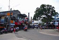 Downtown Ubay | ||
| ||
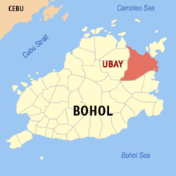 Map of Bohol with Ubay highlighted | ||
.svg.png) Ubay Location within the Philippines | ||
| Coordinates: 10°03′N 124°28′E / 10.05°N 124.47°ECoordinates: 10°03′N 124°28′E / 10.05°N 124.47°E | ||
| Country |
| |
| Region | Central Visayas (Region VII) | |
| Province | Bohol | |
| Founded Chartered |
15 January 1844 5 October 1877 | |
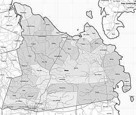
| Barangays | 44 (see Barangays) | |
| Government [1] | ||
| • Type | Sangguniang Bayan | |
| • Mayor | Constantino Reyes | |
| • Vice Mayor | Nelson Uy | |
| • Congressman | Erico Aristotle Aumentado | |
| • Electorate | 41,792 voters (2016) | |
| Area [2] | ||
| • Total | 335.06 km2 (129.37 sq mi) | |
| Population (2015 census)[3] | ||
| • Total | 73,712 | |
| • Density | 220/km2 (570/sq mi) | |
| Time zone | UTC+8 (PST) | |
| ZIP code | 6315 | |
| PSGC | 071246000 | |
| IDD : area code | +63 (0)38 | |
| Climate type | Tropical monsoon climate | |
| Income class | 1st municipal income class | |
| Revenue (₱) | 181,608,793.67 (2016) | |
| Native languages |
Boholano dialect Cebuano Tagalog | |

Ubay, officially the Municipality of Ubay, (Cebuano: Lungsod sa Ubay; Tagalog: Bayan ng Ubay), is a 1st class municipality in the province of Bohol, Philippines. According to the 2015 census, it has a population of 73,712 people.[3]
Ubay is in the northeast of the province, and has an area of 335 square kilometres (129 sq mi), with 61 kilometres (38 mi) of coastline. It is the largest and most populated municipality in Bohol.
Etymology
|
One etymology derivation is that the town's name is a contraction of the term ubay-ubay, meaning "alongside".[4] According to Kaufmann's 1934 Visayan-English Dictionary,[5] the Visayan word "ubay" means:
|
The flow of seawater between the mainland and the island of Lapinig Grande (now Pres. C.P. Garcia town) could justify the second definition of Ubay. It is a situation that is permanent and the constant reference to the flow of water can make the term ubay be attached as the name of the place.
An alternative derivation is that the term 'ubay-ubay' or 'alongside' became the byword of seafarers who used to travel close to the shorelines of Ubay to avoid the strong current of the Canigao Channel. There was a single path to follow reach the island trading centres. This trail was located alongside (ubay) the sandy beach. Later on the term Ubay became the original name of the community.
History
Before the Spanish regime, Ubay was part of Talibon. On 15 January 1844, it separated from Talibon to become an independent municipality.[4]
The religious aspect of the town was established much later than the civil aspect of the town. The decree of the Spanish Governor General creating Ubay as a town in the religious aspect is dated 22 October 1877. However, Royal Order No. 695 issued by the Kingdom of Spain has the date 5 October 1877.
The town celebrates its fiesta every 29 January in commemoration and honor of their patron saint, Holy Child.[6] Ubayanons often come home during fiesta to share the joy of reviving the beautiful old story on the origin of the place.
Geography
The town is situated east of Trinidad, north of Alicia and Mabini, and northeast of San Miguel. It is 124 kilometres (77 mi) northeast of Tagbilaran, 636 kilometres (395 mi) southeast of Manila and 71 kilometres (44 mi) east of Cebu City.
Climate
| Ubay Average annual temperature in Ubay is 27·2°C Humidity 75–85% | ||||||||||||||||||||||||||||||||||||||||||||||||||||||||||||
|---|---|---|---|---|---|---|---|---|---|---|---|---|---|---|---|---|---|---|---|---|---|---|---|---|---|---|---|---|---|---|---|---|---|---|---|---|---|---|---|---|---|---|---|---|---|---|---|---|---|---|---|---|---|---|---|---|---|---|---|---|
| Climate chart (explanation) | ||||||||||||||||||||||||||||||||||||||||||||||||||||||||||||
| ||||||||||||||||||||||||||||||||||||||||||||||||||||||||||||
| ||||||||||||||||||||||||||||||||||||||||||||||||||||||||||||
The climate is typically equatorial – temperature range over the year is less than three degrees Celsius (5.4 deg F), and annual rainfall exceeds 1,500 millimetres (59 in). The dry season starts in February and lasts through April sometimes extending to mid‑May. The climate in Ubay falls within Coronas climate type IV, characterised by not very pronounced maximum rainfall with a short dry season from one to three months and a wet season of nine to ten months.[7]
Ubay has a tropical climate. Most months of the year are marked by significant precipitation, making agriculture favorable – it supports at least two rice crops per year. The short dry season has little impact. Ubay is classified as Am (Tropical monsoon climate) by Köppen–Geiger climate classification system.
Barangays
Ubay comprises 44 barangays organized into eight urban districts (UD):
| PSGC | Barangay | Population | ±% p.a. | Area | PD 2015 | UD | Date of Fiesta | |||||
|---|---|---|---|---|---|---|---|---|---|---|---|---|
| 2015[3] | 2010[8] | ha | acre | /km2 | /sq mi | |||||||
| 071246001 | Achila | 1.9% | 1,429 | 1,276 | 2.18% | 384 | 949 | 370 | 960 | IV | 15 January | |
| 071246002 | Bay‑ang | 2.6% | 1,906 | 1,656 | 2.71% | 632 | 1,562 | 300 | 780 | III | 21 May | |
| 071246005 | Benliw | 3.0% | 2,193 | 2,223 | −0.26% | 589 | 1,455 | 370 | 960 | VII | 13 May | |
| 071246004 | Biabas | 3.5% | 2,599 | 2,573 | 0.19% | 2,200 | 5,436 | 120 | 310 | VIII | 17 May | |
| 071246007 | Bongbong | 1.2% | 895 | 807 | 1.99% | 161 | 398 | 560 | 1,400 | II | 8 December | |
| 071246008 | Bood | 3.8% | 2,833 | 2,717 | 0.80% | 152 | 376 | 1,900 | 4,800 | V | 15 January | |
| 071246009 | 1.0% | 709 | 688 | 0.57% | 651 | 1,609 | 110 | 280 | I | Last Saturday of April 29 Apr 2017 28 Apr 2018 27 Apr 2019 | ||
| 071246055 | Bulilis | 2.8% | 2,046 | 1,711 | 3.46% | 740 | 1,829 | 280 | 720 | II | 8 December | |
| 071246011 | Cagting | 2.3% | 1,712 | 1,597 | 1.33% | 1,044 | 2,580 | 160 | 420 | VII | 24 January | |
| 071246027 | Calanggaman | 2.3% | 1,689 | 1,623 | 0.76% | 618 | 1,527 | 270 | 710 | III | 8 December | |
| 071246056 | California | 1.3% | 941 | 801 | 3.11% | 319 | 788 | 290 | 760 | II | 13 May | |
| 071246012 | Camali‑an | 0.9% | 642 | 581 | 1.92% | 532 | 1,315 | 120 | 310 | III | 26 November | |
| 071246013 | Camambugan | 3.5% | 2,591 | 2,251 | 2.71% | 547 | 1,352 | 470 | 1,200 | IV | 15 May | |
| 071246015 | Casate | 3.6% | 2,661 | 2,512 | 1.10% | 460 | 1,137 | 580 | 1,500 | IV | 5 April | |
| 071246017 | Cuya | 0.7% | 538 | 516 | 0.80% | 66 | 163 | 820 | 2,100 | VIII | 6 February | |
| 071246018 | Fatima | 4.5% | 3,340 | 3,235 | 0.61% | 66 | 163 | 5,100 | 13,000 | V | 13 May | |
| 071246019 | Gabi | 1.9% | 1,432 | 1,378 | 0.73% | 1,646 | 4,067 | 87 | 230 | II | 9 December | |
| 071246020 | Governor Boyles | 1.2% | 885 | 888 | −0.06% | 824 | 2,036 | 110 | 280 | I | 15 May | |
| 071246021 | Guintabo‑an | 0.9% | 676 | 686 | −0.28% | 66 | 163 | 1,000 | 2,700 | VIII | 15 January | |
| 071246022 | Hambabauran | 1.6% | 1,205 | 1,106 | 1.65% | 521 | 1,287 | 230 | 600 | III | 15 January | |
| 071246023 | Humayhumay | 2.4% | 1,802 | 1,708 | 1.03% | 815 | 2,014 | 220 | 570 | IV | 14 February | |
| 071246024 | Ilihan | 1.0% | 768 | 802 | −0.82% | 683 | 1,688 | 110 | 290 | I | 15 May | |
| 071246025 | Imelda | 2.5% | 1,865 | 1,761 | 1.10% | 657 | 1,624 | 280 | 740 | VII | 8 May & 27 November | |
| 071246026 | Juagdan | 1.6% | 1,185 | 1,121 | 1.06% | 121 | 299 | 980 | 2,500 | VII | 23 May | |
| 071246016 | Katarungan | 2.3% | 1,680 | 1,524 | 1.87% | 409 | 1,011 | 410 | 1,100 | V | 30 May | |
| 071246031 | Lomangog | 3.6% | 2,650 | 2,025 | 5.26% | 642 | 1,586 | 410 | 1,100 | II | 15 January | |
| 071246030 | Los Angeles | 0.8% | 601 | 436 | 6.30% | 274 | 677 | 220 | 570 | II | 27 April | |
| 071246032 | Pag‑asa | 1.7% | 1,273 | 1,168 | 1.65% | 378 | 934 | 340 | 870 | III | 8 December | |
| 071246033 | Pangpang | 1.8% | 1,328 | 1,220 | 1.63% | 450 | 1,112 | 300 | 760 | IV | 15 December | |
| 071246034 | Poblacion | 4.5% | 3,331 | 3,633 | −1.64% | 199 | 492 | 1,700 | 4,300 | V | Last Friday of January 27 Jan 2017 26 Jan 2018 25 Jan 2019 | |
| 071246037 | San Francisco | 2.3% | 1,688 | 1,677 | 0.12% | 1,107 | 2,736 | 150 | 390 | I | 26 June | |
| 071246038 | San Isidro | 1.0% | 771 | 707 | 1.66% | 262 | 647 | 290 | 760 | VI | 21 May | |
| 071246040 | San Pascual | 5.1% | 3,783 | 3,127 | 3.69% | 973 | 2,404 | 390 | 1,000 | I | Last Saturday of April 29 Apr 2017 28 Apr 2018 27 Apr 2019 | |
| 071246041 | San Vicente | 1.4% | 1,056 | 1,074 | −0.32% | 966 | 2,387 | 110 | 280 | VIII | 5 April | |
| 071246043 | Sentinela | 1.3% | 939 | 969 | −0.60% | 271 | 670 | 350 | 900 | VI | 29 May | |
| 071246044 | Sinandigan | 3.0% | 2,242 | 1,874 | 3.47% | 607 | 1,500 | 370 | 960 | VII | 8 December | |
| 071246045 | Tapal | 2.1% | 1,516 | 1,371 | 1.93% | 290 | 717 | 520 | 1,400 | VI | 3 May | |
| 071246046 | Tapon | 3.8% | 2,828 | 2,481 | 2.52% | 153 | 378 | 1,800 | 4,800 | V | 29 June | |
| 071246047 | Tintinan | 1.0% | 707 | 623 | 2.44% | 31 | 77 | 2,300 | 5,900 | VIII | 29 September | |
| 071246048 | Tipolo | 3.4% | 2,526 | 2,456 | 0.54% | 655 | 1,619 | 390 | 1,000 | VI | 5 April | |
| 071246049 | Tubog | 1.3% | 983 | 885 | 2.02% | 514 | 1,270 | 190 | 500 | III | 16 May | |
| 071246050 | Tuboran | 1.9% | 1,394 | 1,372 | 0.30% | 547 | 1,352 | 250 | 660 | IV | 15 January | |
| 071246052 | Union | 3.2% | 2,392 | 2,332 | 0.48% | 514 | 1,270 | 470 | 1,200 | VI | 15 January | |
| 071246054 | Villa Teresita | 2.0% | 1,482 | 1,407 | 0.99% | 262 | 647 | 570 | 1,500 | I | 28 November | |
| Total | 73,712 | 68,578 | 1.38% | 33,506 | 82,795 | 220 | 570 | |||||
Demographics
| Population census of Ubay | |||||||||||||||||||||||||||||||||||||||||||||||||
|---|---|---|---|---|---|---|---|---|---|---|---|---|---|---|---|---|---|---|---|---|---|---|---|---|---|---|---|---|---|---|---|---|---|---|---|---|---|---|---|---|---|---|---|---|---|---|---|---|---|
|
| ||||||||||||||||||||||||||||||||||||||||||||||||
| Source: Philippine Statistics Authority[3][8][9] | |||||||||||||||||||||||||||||||||||||||||||||||||
When the first national census was held in 1903, the municipality had a population 7,355. It continued to grow until 1960 with 34,090 (annual growth rate of 2.73% over the period). The population markedly decreased in 1970 with the creation of the municipality of President Carlos P. Garcia, formerly a constituent barangay. Since 1970, average annual growth rate (1970–2015) is 1.82%.
The primary language is Cebuano: Filipino and English are understood to a limited degree.
Economy
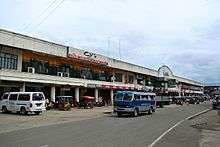
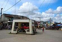
Ubay has a number of business establishments mostly small-scale commercial trading firms engaged in retail and wholesale. A new public market building was completed recently. The regular market day is Monday and local traders from neighboring towns come to sell their merchandise consisting mostly of agricultural products and small consumer items like used clothes, household utensils and other products. Ubay also provides a market for the neighboring island municipality of Pres. Carlos P. Garcia.
Tourism and culture

Ubay's point of interests, destinations, and attractions include:
- Ubay Stock Farm (USF): Started in 1921 and occupying 4,500 hectares (11,120 acres), it is the largest and oldest government livestock facility in the Philippines. The place was chosen as one of the accredited livestock technology training facilities for Visayas and Mindanao. It is located in Lomangog.[10]
- Bohol Experimental Station: The Integrated Agricultural Research Center of Department of Agriculture in Central Visayas PhilRice's national lead agency for the planning, coordination, implementation, and monitoring of all rice research and development activities in the Philippines. It is located in Gabi.
- Capayas Dam (or Kapayas)(sometimes known as Banana Dam): One of the largest dams in the province and located alongside the main Ubay—Alicia—Guindulman highway. The southern end is in Lumangog, the remainder in Imelda. Completed in December 1991, it irrigates 750 hectares (1,900 acres) and serves 688 farm households. In 2011, the Department of Agriculture seeded the dam with 30,000 tilapia fingerlings, as part of their sustainable food security program.[11]
- Ubay Agri-Park: The first of its kind in the Visayan region was recently launched to boost the agriculture and tourism industries in the area. A 100-hectare (250-acre) area situated along the national highway in Lomangog, Ubay Agri-Park helps to promote agri-tourism or "farm tourism," and is a showcase of Bohol's advances in farm technology.
- Sinandigan Multi-Species Hatchery: It is the biggest multi-species hatchery farm in the Philippines.[12] A fishery infrastructure and mariculture park established to enable the fish farmers to become totally independent from wild stocks and to promote a more stable food security for the province. The facility is producing fingerlings of various fisheries products such as, but not limited to, milkfish (bangus), groupers (lapulapu), and siganids (kitong, danggit). It also houses a seaweed tissue culture laboratory which aims to rehabilitate quality seagrass planting materials using tissue branch culture, spore shredding and callus cell culture. It is supervised by the Bureau of Fisheries and Aquatic Resources (BFAR) and inaugurated in April 2011.[13]
- Gaviola Ancestral House: Located in the Población near the church plaza, this Filipino-Spanish house was the residence of Don Ruperto Gaviola (former mayor of Ubay). The two-storey house has a traditional cut stone ground and a wooden painted ceiling made by Cebuano artist Ray Francia.[14][15]
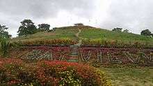
- Ubay Green Park and Techno Center: Formerly, an open dumpsite converted into an ecological facility. The park was launched in 2013, which consists of flower and fruit gardens. It is located in sitio Palayan (Purok 7) barangay Imelda.[16]
Delicacies
- Ube Calamay: It is a purple rice cake, (Calamay) with Ube. This sweet and delightful delicacy is said to be originated from this town because of its large plantations of Ube (purple yam).
- Fried Ube bread: Another mouthwatering delicacy made of ube. It is bread deep‑fried then filled with purple yam.
Ubay-ubay Festival
Like the Sinulog of Cebu, the Ubay-ubay Festival is the town's own version in celebration and honor of the patron saint, Sr. Santo Niño. This colorful and fascinating festivity is a well-attended event where people flock the town's major roads and venues to view the grand street parade and the festival dance-competition. This celebration is held each 28 – 30 January.[17]
Local government
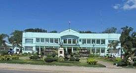
Ubay is governed by the municipal mayor as head of the municipality. The vice mayor is the next highest position and acts as the presiding officer of municipal council.
| Term | Title | Name |
|---|---|---|
| 1844 | Gobernadorcillo | Toribio Reyes |
| 1912 – 1924 | Presidente Municipal | Ruperto Gaviola |
| 1925 – 1930 | Presidente Municipal | Jose Garces |
| 1931 – 1935 | Presidente Municipal | Carlos Boiser |
| 1936 – 1940 | Presidente Municipal | Ruperto Gaviola |
| 1941 – 1942 | Presidente Municipal | Lucio Cutanda |
| 1942 – 1943 | Military Mayor | Samson Sabalones |
| 1944 – 1945 | Military Mayor | Frank Lombardo |
| 1946 – 1948 | Municipal Mayor | Lucio Cutanda |
| 1949 – | OIC Municipal Mayor | Marcelo Cuyno |
| 1949 – 1952 | Municipal Mayor | Lucio Cutanda |
| 1953 – 1964 | Municipal Mayor | Ricardo Boyles |
| 1965 – 1968 | Municipal Mayor | Sabiniano Cuyno |
| 1969 – 1978 | Municipal Mayor | Rufina Delima |
| 1979 – 1980 | OIC Municipal Mayor | Eutiquio Bernales[18] |
| 1981 – 1984 | Municipal Mayor | Eutiquio Bernales |
| 1985 – 1986 | OIC Municipal Mayor | Pedro Sarabosing |
| 1986 – 1987 | OIC Municipal Mayor | Agapito Valleser |
| 1987 – 1992 | Municipal Mayor | Eliseo Boyles[19] |
| 1992 – 1998 | Municipal Mayor | Eutiquio Bernales |
| 1998 – 2004 | Municipal Mayor | Manuel Alesna |
| 2004 – 2013 | Municipal Mayor | Eutiquio Bernales |
| 2013 – 2016 | Municipal Mayor | Galicano Atup |
| 2016 – present | Municipal Mayor | Constantino Reyes |
Infrastructure
Transport
The most common form of local transportation is the tricycle for nearer barangays. For far barangays, the motorcycle is the most common. All barangays are connected by roads and the only places without roads are the steep slopes of the central mountains.
The improvement of the Bohol circumferential road and the port facilities helped Ubay to become the trading and transportation hub of northeastern Bohol, connecting it to the neighboring island of Leyte and the rest of Bohol province. Passenger and cargo traffic to these destinations has noticeably increased over the years indicating an increasing volume of trade between these points.
Land transportation is provided by various short and long-distance buses, jeeps and vans, connecting Ubay to the rest of the towns in the province. Tagbilaran can be reached from Ubay in two to three hours by bus or van. There are also daily combined road/ferry services to Metro Manila (Pasay City / Cubao, Quezon City).
Ubay seaport is considered the province's principal gateway to Leyte, and Samar.[20] Its improved port area is linked to the major port destinations of neighboring provinces such as Bato and Hilongos in Leyte, Maasin City in Southern Leyte, and Cebu City, the regional capital.[21] Four vessels travels to and from Cebu City daily,[20] and routes to and from Bato, Hilongos and Maasin City are also served daily. The journey time for each destination is 4–5 hours.[22]
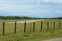
Ubay is home to one of only two airports in Bohol (the other being Tagbilaran Airport), but Ubay Airport is completely undeveloped and has no scheduled service, nor any facilities. The runway currently is only about 400 metres (1,310 ft) long but couldn't extend at the southwestern end becomes it is close to hills, and the northeastern end reaches housing and the sea.[23]
Health
For health services, the town has two public health units staffed by doctors, nurses, midwives, dentists, medical technologists and sanitary inspectors. A small government hospital was established to provide outpatient services to local residents. A private 15-bed hospital in Fatima also provides services for emergencies. A pediatrics and OB-gynae clinic complements the health services available in town.
Barangay Health Workers (BHW) from each barangay provide direct health care assistance to barangay residents.
Public order and safety
The local police force is 37 police officers. Police–population ratio is 1:1,992, less favourable than the standard ratio of 1:1,000. The police are augmented by 492 Barangay Tanod volunteers. It is reported that crime rate in Ubay is relatively low. The local Fire Department is staffed by eight fire fighters with two fire trucks. Incidence of fires is reportedly low in the municipality.
Utilities
Bohol was linked to the major source of geothermal power in Leyte through the underwater connection between Maasin City, Southern Leyte and Ubay. Presently, only three of the 44 barangays have no electricity, yet only 34.97 percent of the total households in the municipality have electricity compared to the province, which was 58.3 percent energized in 2000.
The town proper and seven other barangays was served by the Ubay Water Service Cooperative. The cooperative planned to expand their service to eight other barangays in the near future. Due to consumer demand and the limited size of the supply, water service became difficult during dry months. Bohol province reported that 23.71 percent of its households had their own faucets from a community system while Ubay reported only 8.97 percent.
For the province, 21.68 percent of households had access to shared faucets while Ubay only had 8.86 percent. In Ubay, slightly more than half (51.83%) of the households had access to dug wells.
Education
Elementary schools
There are 44 public elementary schools in the municipality – one in each barangay except Cuya, and one on Tres Reyes island.[24]
There are 7 private elementary schools.[25]
Secondary and high schools
There are 16 public and private secondary and high schools in the municipality.[26]
Higher education
To meet the increasing demands Bohol Northeastern College was founded in 1996 by Ubayano political leaders, Erico B. Aumentado and former governor David B. Tirol. The name was changed to Bohol Northern Star Colleges in January 2007.
Notable Ubayanons
- Erico B. Aumentado – the only Bohol governor who served three consecutive terms (2001–2010), former deputy speaker of the Philippine House of Representatives, former congressman of Bohol's 2nd District, former provincial vice-governor and Board Member.[27]
- Eutiquio Boyles – who served as the fifth provincial governor of Bohol from 16 October 1916 – 15 October 1919. Barangay Governor Boyles was named after him.[28]
References
- ↑ "Municipality". Quezon City, Philippines: Department of the Interior and Local Government. Retrieved 31 May 2013.
- ↑ "Province: Bohol". PSGC Interactive. Quezon City, Philippines: Philippine Statistics Authority. Retrieved 12 November 2016.
- 1 2 3 4 Census of Population (2015). "Region VII (Central Visayas)". Total Population by Province, City, Municipality and Barangay. PSA. Retrieved 20 June 2016.
- 1 2 "Municipality of Balilihan". Province of Bohol. Retrieved 10 September 2012.
- ↑ Kaufmann 1934.
- ↑ Calendar for January 2018
- ↑ Coronas 1920.
- 1 2 Census of Population and Housing (2010). "Region VII (Central Visayas)". Total Population by Province, City, Municipality and Barangay. NSO. Retrieved 29 June 2016.
- ↑ Censuses of Population (1903–2007). "Region VII (Central Visayas)". Table 1. Population Enumerated in Various Censuses by Province/Highly Urbanized City: 1903 to 2007. NSO.
- ↑ "Ubay Stock Farm". Cebu Daily News. Retrieved October 21, 2012.
- ↑ Espinola & Maghirang 2014.
- ↑ "DA, BFAR as partners for Bohol's self-sufficiency". EDCom Bohol. April 21, 2011. Retrieved October 20, 2014.
- ↑ "Sinandigan Multi-Species Hatchery". Bohol Sunday Post. April 24, 2011. Retrieved October 20, 2014.
- ↑ Akpenodu & Saloma 2011.
- ↑ "Gaviola Ancestral House". GV Hotel. January 1, 2013. Retrieved October 22, 2014.
- ↑ "List of Good Practices - DILG, Province of Bohol". DILG. December 30, 2013. Retrieved May 15, 2017.
- ↑ "Ubay Annual Town Fiesta". Ubay LGU. January 1, 2013. Retrieved October 22, 2014.
- ↑ "Eutiquio M. Bernales". Bohol Choice Cuts. 2004-07-04. Retrieved 2013-12-21.
- ↑ Boysillo, Florencio (October 1990). "The Province of Bohol". Ubay Past and Present. 47: 11.
- 1 2 "Ubay Seaport". Bohol-Philippines.com. 1 February 2014. Retrieved 8 March 2014.
- ↑ Bohol Standard 2010.
- ↑ "The Southern Leyte Connection". Leyte-Divers.com. 1 February 2012. Retrieved 8 March 2015.
- ↑ Bohol News Today 2016.
- ↑ "List of Public Schools in Bohol 2nd District" (Spreadsheet). DepEd Bohol. Retrieved 21 Oct 2012.
- ↑ "List and Status of Private Schools as of January 22, 2015" (PDF). Deped - Central Visayas. January 31, 2015. Archived from the original (PDF) on April 2, 2015. Retrieved March 5, 2015.
- ↑ "List of Public Schools in Bohol 2nd District". DepEd Bohol. Retrieved 21 Oct 2012.
- ↑ Bohol Chronicle 2013.
- ↑ "Bohol Governors, Past and Present". Province of Bohol. Retrieved 25 December 2012.
Sources
- Akpenodu, Erik; Saloma, Czarina (2011). Casa Boholana: Vintage Houses of Bohol. Ateneo de Manila University Press. ISBN 978-9715506182.
- Bohol Chronicle, Antonio Amora. "A Legacy of Life and Work". Archived from the original on 16 January 2014. Retrieved 25 December 2013.
- Bohol News Today, June S. Blanco (20 March 2016). "P56M Ubay airport bidding sked in Q2". Archived from the original on 30 March 2016.
- Bohol Standard (4 July 2010). "Ubay port offers a better life for many Boholanos". Archived from the original on 9 April 2015. Retrieved 8 March 2015.
- Coronas, José (1920). The Climate and Weather of the Philippines, 1903 – 1918. Manila Observatory: Bureau of Philippines.
- Espinola, Manny; Maghirang, Antonio (2014). Ave, Jon P.; Rodriguez, Ces, eds. "NIA at 50 : A Legacy of Serving Filipino Farmers" (PDF). Photography Raneil Ibay; Graphic Artists: Mario Sta. Maria, Shannon Olaguer; Research Assistants: Jun Danganan, CJ Brillantes. pp. 62–63. ISBN 978-9719596202.
- Kaufmann, J. (1934). Visayan-English Dictionary (PDF). Iloilo.
- Saz, Efren B. (2007). A comprehensive assessment of the agricultural extension system in the Philippines: case study of LGU extension in Ubay, Bohol (PDF). Philippine Institute for Development Studies, University of Leyte. Retrieved 24 January 2015.
| Wikimedia Commons has media related to Ubay. |
External links
Places adjacent to Ubay, Bohol | |
|---|---|