President Carlos P. Garcia, Bohol
| President Carlos P. Garcia | |
|---|---|
| Municipality | |
| Municipality of President Carlos P. Garcia | |
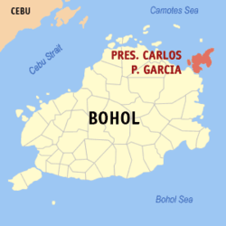 Map of Bohol with President Carlos P. Garcia highlighted | |
.svg.png) President Carlos P. Garcia Location within the Philippines | |
| Coordinates: 10°07′N 124°33′E / 10.12°N 124.55°ECoordinates: 10°07′N 124°33′E / 10.12°N 124.55°E | |
| Country |
|
| Region | Central Visayas (Region VII) |
| Province | Bohol |
| District | 2nd District |
| Founded Renamed |
21 June 1969 4 November 1977 |
| Barangays | 23 (see Barangays) |
| Government [1] | |
| • Type | Sangguniang Bayan |
| • Mayor | Fernando Estavilla |
| • Vice Mayor | Renato Sente |
| • Congressman | Erico Aristotle Aumentado |
| • Electorate | 14,455 voters (2016) |
| Area [2] | |
| • Total | 54.82 km2 (21.17 sq mi) |
| Population (2015 census)[3] | |
| • Total | 23,356 |
| • Density | 430/km2 (1,100/sq mi) |
| Time zone | UTC+8 (PST) |
| ZIP code | 6346 |
| PSGC | 071235000 |
| IDD : area code | +63 (0)38 |
| Climate type | Tropical monsoon climate |
| Income class | 4th municipal income class |
| Revenue (₱) | 65,952,733.40 (2016) |
| Native languages |
Boholano dialect Cebuano Tagalog |
President Carlos P. Garcia, officially the Municipality of President Carlos P. Garcia, (Cebuano: Lungsod sa President Carlos P. Garcia; Tagalog: Bayan ng President Carlos P. Garcia), is a 4th class municipality in the province of Bohol, Philippines. According to the 2015 census, it has a population of 23,356 people.[3]
It primarily consists of Lapinig Island along with a few surrounding islets. According to the 2015 census, it has a population of 23,356.[3]
History
In the early part of the 19th century, the place was part of the municipality of Ubay, known as Lapinig Grande and subdivided into six barrios: Pitogo, Aguining, Basiao, Bonbonon, Gaus, and Tugas.
Congressman Teodoro Galagar of the 3rd Congressional District of the province of Bohol, initiated the formation of Lapining Grande into a town. Aguining, Pitogo, and Bonbonon were the barangays bidding for township. On 21 June 1969, RA 5864 was approved creating Pitogo as the 46th town of the province of Bohol with 23 regular barangays.[4] Eight years later on 27 October 1977, it was renamed by Presidential Decree 1228 in honour of President Carlos P. Garcia,[5] who was born in nearby Talibon.
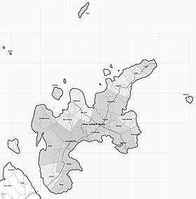
Barangays
President Carlos P. Garcia comprises 23 barangays:
| PSGC | Barangay | Population | ±% p.a. | |||
|---|---|---|---|---|---|---|
| 2015[3] | 2010[6] | |||||
| 071235001 | Aguining | 9.3% | 2,175 | 2,294 | −1.01% | |
| 071235003 | Basiao | 3.8% | 898 | 911 | −0.27% | |
| 071235004 | Baud | 2.7% | 633 | 603 | 0.93% | |
| 071235005 | Bayog | 1.3% | 304 | 309 | −0.31% | |
| 071235006 | Bogo | 4.8% | 1,128 | 990 | 2.52% | |
| 071235007 | Bonbonon | 5.5% | 1,296 | 1,286 | 0.15% | |
| 071235023 | Butan | 2.4% | 569 | 626 | −1.80% | |
| 071235009 | Campamanog | 6.9% | 1,607 | 1,560 | 0.57% | |
| 071235008 | Canmangao | 4.0% | 939 | 948 | −0.18% | |
| 071235010 | Gaus | 5.1% | 1,202 | 1,365 | −2.39% | |
| 071235011 | Kabangkalan | 2.0% | 456 | 309 | 7.69% | |
| 071235012 | Lapinig | 3.8% | 896 | 967 | −1.44% | |
| 071235013 | Lipata | 2.5% | 595 | 685 | −2.65% | |
| 071235014 | Poblacion (Pitogo) | 11.8% | 2,745 | 2,700 | 0.32% | |
| 071235015 | Popoo | 4.2% | 985 | 977 | 0.16% | |
| 071235016 | Saguise | 3.1% | 715 | 745 | −0.78% | |
| 071235017 | San Jose (Tawid) | 5.1% | 1,186 | 1,109 | 1.29% | |
| 071235024 | San Vicente | 4.5% | 1,047 | 893 | 3.08% | |
| 071235018 | Santo Rosario | 1.4% | 322 | 475 | −7.13% | |
| 071235019 | Tilmobo | 0.9% | 202 | 197 | 0.48% | |
| 071235020 | Tugas | 3.1% | 723 | 756 | −0.85% | |
| 071235021 | Tugnao | 5.6% | 1,311 | 1,309 | 0.03% | |
| 071235022 | Villa Milagrosa | 6.1% | 1,422 | 1,273 | 2.13% | |
| Total | 23,356 | 23,287 | 0.06% | |||
Demographics
| Population census of President Carlos P. Garcia | ||
|---|---|---|
| Year | Pop. | ±% p.a. |
| 1970 | 8,831 | — |
| 1975 | 16,597 | +13.49% |
| 1980 | 18,142 | +1.80% |
| 1990 | 21,173 | +1.56% |
| 1995 | 19,096 | −1.92% |
| 2000 | 20,744 | +1.79% |
| 2007 | 25,118 | +2.67% |
| 2010 | 23,287 | −2.72% |
| 2015 | 23,356 | +0.06% |
| Source: Philippine Statistics Authority[3][6][7][8] | ||
Education
-
- Aguining National High School
- Basiao High School
- Bonbonon High School
- Campamanog High School
- Gaus High School
- Holy Child Academy
- Mayor Inocencio B. Mendez High School
- Elementary Schools
There are 20 elementary schools.
See also
References
- ↑ "Municipality". Quezon City, Philippines: Department of the Interior and Local Government. Retrieved 31 May 2013.
- ↑ "Province: Bohol". PSGC Interactive. Quezon City, Philippines: Philippine Statistics Authority. Retrieved 12 November 2016.
- 1 2 3 4 5 Census of Population (2015). "Region VII (Central Visayas)". Total Population by Province, City, Municipality and Barangay. PSA. Retrieved 20 June 2016.
- ↑ Republic Act No. 5864 (21 June 1969), An act creating the Municipality of Pitogo in the province of Bohol, retrieved 14 July 2016
- ↑ Presidential Decree No. 1228 (27 October 1977), Amending Republic Act No. 5864 entitled "An act creating the Municipality of Pi‑togo in the province of Bohol", retrieved 14 July 2016
- 1 2 Census of Population and Housing (2010). "Region VII (Central Visayas)". Total Population by Province, City, Municipality and Barangay. NSO. Retrieved 29 June 2016.
- ↑ Censuses of Population (1903–2007). "Region VII (Central Visayas)". Table 1. Population Enumerated in Various Censuses by Province/Highly Urbanized City: 1903 to 2007. NSO.
- ↑ "Province of Bohol". Municipality Population Data. Local Water Utilities Administration Research Division. Retrieved 17 December 2016.
- ↑ "List of High Schools". DepEd – Bohol. 1 January 2015. Retrieved 5 March 2015.
- ↑ "Catholic Educational Institutions". Roman Catholic Diocese of Talibon. 1 January 2014. Archived from the original on 2015-02-04. Retrieved 5 March 2015.
External links
Places adjacent to President Carlos P. Garcia, Bohol | ||||||||||
|---|---|---|---|---|---|---|---|---|---|---|
| ||||||||||