Tubigon
| Tubigon | |
|---|---|
| Municipality | |
| Municipality of Tubigon | |
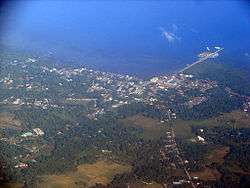 Aerial view of Tubigon, Bohol | |
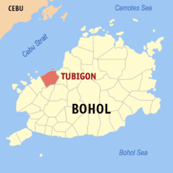 Map of Bohol with Tubigon highlighted | |
.svg.png) Tubigon Location within the Philippines | |
| Coordinates: 9°57′N 123°58′E / 9.95°N 123.97°ECoordinates: 9°57′N 123°58′E / 9.95°N 123.97°E | |
| Country |
|
| Region | Central Visayas (Region VII) |
| Province | Bohol |
| District | 1st District |
| Founded | 1819 |
| Barangays | 34 (see Barangays) |
| Government [1] | |
| • Type | Sangguniang Bayan |
| • Mayor | William Richard Jao |
| • Vice Mayor | Virgilio Fortich |
| • Congressman | Rene Relampagos |
| • Electorate | 26,394 voters (2016) |
| Area [2] | |
| • Total | 81.87 km2 (31.61 sq mi) |
| Population (2015 census)[3] | |
| • Total | 45,893 |
| • Density | 560/km2 (1,500/sq mi) |
| Time zone | UTC+8 (PST) |
| ZIP code | 6329 |
| PSGC | 071245000 |
| IDD : area code | +63 (0)38 |
| Climate type | Tropical monsoon climate |
| Income class | 1st municipal income class |
| Revenue (₱) | 162,054,193.55 (2016) |
| Native languages |
Boholano dialect Cebuano Tagalog |
| Website |
www |
Tubigon, officially the Municipality of Tubigon, (Cebuano: Lungsod sa Tubigon; Tagalog: Bayan ng Tubigon), is a 1st class municipality in the province of Bohol, Philippines. According to the 2015 census, it has a population of 45,893 people.[3]
Located 51 kilometres (32 mi) from Tagbilaran, it is the nearest seaport in Bohol to Cebu, providing many daily ferry round-trips to Cebu City. It has recently expanded its seaport to accommodate additional sea traffic.[4]
Tubigon is well known for its "lambay" crabs.
History
The first settlers in Tubigon settled along the shores of the river that flows through the community. Their exact origins are unknown but they are thought to be early Malays from southeast Asian countries, migrating to the Philippines in small bangkas. Seasonal overflowing of the river flooded the community and led the place to be called "Tubigan" (meaning "place having water" or "watery"), which later morphed into "Tubigon" (meaning "place abounding in water"). The first record of the town of Tubigon dates from the early part of the 1600s.[5][6]
In 1816, the community organized itself under a recognized headman, Yguiz Hutora, who was succeeded by teniente Mijares and by teniente Matong in 1818. A chapel was built on an elevated site of the settlement but had no officiating priest. A coadjutor of the Spanish friars from the Calape parish would perform the religious ceremonies.[5]
In 1819, by authority of the Spanish Governor of Cebu, Tubigon was formally organized into an independent town by separating from the town of Calape, with Capitan Teniente Matong becoming the first gobernadorcillo.[5]
Starting in 1852, the exact boundaries of the municipality were defined. On 8 March of that year, sitio Bacane was made the boundary between Tubigon and Inabanga. In 1856, the boundary with Calape was fixed at Mandaug. On 19 June 1865, the boundary between Tubigon and Catigbian was set at the Sampilangon River and on 14 September 1913, the boundary with Antequera (currently San Isidro) was fixed at sitio Tubod.[5]
On 31 January 1919, Tubigon lost five barrios when Clarin was formed by virtue of proclamation by Governor Yeater.[5][7]
Tubigon was badly affected by the 2013 Bohol earthquake, suffering 11 fatalities and damage to some 7,300 homes, as well as total destruction of its town hall and church.[8]
Geography
Barangays
Tubigon comprises 34 barangays:
| PSGC | Barangay | Population | ±% p.a. | |||
|---|---|---|---|---|---|---|
| 2015[3] | 2010[9] | |||||
| 071245001 | Bagongbanwa | 2.3% | 1,043 | 876 | 3.38% | |
| 071245003 | Banlasan | 1.9% | 891 | 893 | −0.04% | |
| 071245004 | Batasan (Batasan Island) | 1.9% | 852 | 1,107 | −4.86% | |
| 071245005 | Bilangbilangan | 1.0% | 444 | 567 | −4.55% | |
| 071245006 | Bosongon | 2.8% | 1,295 | 1,070 | 3.70% | |
| 071245007 | Buenos Aires | 2.4% | 1,101 | 945 | 2.95% | |
| 071245002 | Bunacan | 2.1% | 959 | 980 | −0.41% | |
| 071245008 | Cabulihan | 5.4% | 2,477 | 2,327 | 1.20% | |
| 071245009 | Cahayag | 2.7% | 1,243 | 1,213 | 0.47% | |
| 071245010 | Cawayanan | 3.3% | 1,507 | 1,455 | 0.67% | |
| 071245011 | Centro (Poblacion) | 5.4% | 2,471 | 2,821 | −2.49% | |
| 071245012 | Genonocan | 1.5% | 688 | 506 | 6.02% | |
| 071245013 | Guiwanon | 2.7% | 1,261 | 1,210 | 0.79% | |
| 071245014 | Ilihan Norte | 3.0% | 1,384 | 1,498 | −1.50% | |
| 071245015 | Ilihan Sur | 1.4% | 657 | 634 | 0.68% | |
| 071245016 | Libertad | 2.6% | 1,178 | 1,095 | 1.40% | |
| 071245017 | Macaas | 5.2% | 2,391 | 2,266 | 1.03% | |
| 071245019 | Matabao | 2.4% | 1,090 | 1,245 | −2.50% | |
| 071245018 | Mocaboc Island | 1.4% | 624 | 606 | 0.56% | |
| 071245020 | Panadtaran | 1.9% | 864 | 927 | −1.33% | |
| 071245021 | Panaytayon | 4.9% | 2,230 | 2,069 | 1.44% | |
| 071245022 | Pandan | 2.6% | 1,214 | 1,324 | −1.64% | |
| 071245023 | Pangapasan (Pangapasan Island) | 1.1% | 514 | 596 | −2.78% | |
| 071245024 | Pinayagan Norte | 4.8% | 2,212 | 2,082 | 1.16% | |
| 071245025 | Pinayagan Sur | 4.8% | 2,180 | 1,956 | 2.09% | |
| 071245026 | Pooc Occidental (Poblacion) | 1.9% | 851 | 1,131 | −5.27% | |
| 071245027 | Pooc Oriental (Poblacion) | 5.5% | 2,533 | 2,644 | −0.81% | |
| 071245028 | Potohan | 4.7% | 2,137 | 1,868 | 2.59% | |
| 071245029 | Talenceras | 1.8% | 821 | 798 | 0.54% | |
| 071245030 | Tan‑awan | 1.4% | 655 | 883 | −5.53% | |
| 071245031 | Tinangnan | 6.3% | 2,909 | 2,714 | 1.33% | |
| 071245032 | Ubay Island | 0.4% | 196 | 241 | −3.86% | |
| 071245033 | Ubojan | 5.3% | 2,441 | 1,869 | 5.22% | |
| 071245034 | Villanueva | 1.3% | 580 | 486 | 3.42% | |
| Total | 45,893 | 44,902 | 0.42% | |||
Islands
There about 17 minor islands in the municipal, some of whom are inhabited:
- Bagongbanwa
- Batasan
- Bilangbilangan
- Budlaan
- Cabgan
- Cancostino
- Danajon Reef (part)
- Hayaan
- Inanuran
- Maagpit
- Mocaboc
- Pangapasan
- Sib
- Silo
- Taboan Islet
- Tanga‑on
- Ubay Island and Reef
Demographics
| Population census of Tubigon | |||||||||||||||||||||||||||||||||||||||||||||||||
|---|---|---|---|---|---|---|---|---|---|---|---|---|---|---|---|---|---|---|---|---|---|---|---|---|---|---|---|---|---|---|---|---|---|---|---|---|---|---|---|---|---|---|---|---|---|---|---|---|---|
|
| ||||||||||||||||||||||||||||||||||||||||||||||||
| Source: Philippine Statistics Authority[3][9][10][11] | |||||||||||||||||||||||||||||||||||||||||||||||||
Economy
Agriculture and fishing are the primary industries. 60% of the total land area of the municipality is used by agriculture and other related industries. The main agricultural produce includes rice, corn, coconut, bananas and different variety of vegetables.[12]
Electric power is supplied by the Bohol Electric Cooperative I (BOHECO I). Its new administrative building is located in Tubigon along the National Road.
Transportation
- Road
The main National Road is paved and provides easy access to neighboring coastal communities, with travel time to Tagbilaran about one hour. There are inland roads to Catigbian and San Isidro.
Public utility buses are available daily on routes to any point within the province of Bohol. Trips to Tagbilaran are on a 30-minute interval. Cars and vans are available for rent or charter any time.
- Boat and ferry
Tubigon's municipal port is the second largest and busiest port in the province of Bohol. It is served by 6 conventional vessels and 2 modern fastcraft with a total of 20 trips daily to Cebu City. A roll-on/roll-off ferry operated by Lite Shipping Corporation is also operational making two trips daily.[12]
There is no scheduled ferry service to smaller outlying islands, but outrigger canoes may be chartered any time.
Gallery
 Municipal hall (pre-earthquake)…
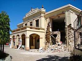 …and after
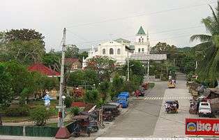 Poblacion
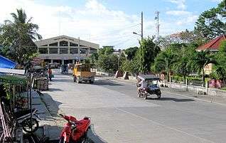 Cultural Center
 Market and Commercial Center
References
- ↑ "Municipality". Quezon City, Philippines: Department of the Interior and Local Government. Retrieved 31 May 2013.
- ↑ "Province: Bohol". PSGC Interactive. Quezon City, Philippines: Philippine Statistics Authority. Retrieved 12 November 2016.
- 1 2 3 4 Census of Population (2015). "Region VII (Central Visayas)". Total Population by Province, City, Municipality and Barangay. PSA. Retrieved 20 June 2016.
- ↑ "Tubigon Port - Wikimapia". wikimapia.org. Retrieved 2015-10-13.
- 1 2 3 4 5 "Historical Background of Tubigon". Welcome to Tubigon, Bohol, Philippines. 2007-06-11. Retrieved 2009-06-15.
- ↑ "Municipality of Tubigon". Provincial Government of Bohol. Archived from the original on 2009-02-01. Retrieved 2009-06-15.
- ↑ "Municipality of Clarin". Provincial Government of Bohol. Archived from the original on 2009-01-24. Retrieved 2009-06-15.
- ↑ "SitRep No. 35 re Effects of Magnitude 7.2 Sagbayan, Bohol Earthquake" (PDF). National Disaster Risk Reduction and Management Council. November 3, 2013. Retrieved November 7, 2013.
- 1 2 Census of Population and Housing (2010). "Region VII (Central Visayas)". Total Population by Province, City, Municipality and Barangay. NSO. Retrieved 29 June 2016.
- ↑ Censuses of Population (1903–2007). "Region VII (Central Visayas)". Table 1. Population Enumerated in Various Censuses by Province/Highly Urbanized City: 1903 to 2007. NSO.
- ↑ "Province of Bohol". Municipality Population Data. Local Water Utilities Administration Research Division. Retrieved 17 December 2016.
- 1 2 "Municipal Profile". Welcome to Tubigon, Bohol, Philippines. 2007-06-11. Retrieved 2009-06-15.
External links


- Municipality of Tubigon
- Tubigon
Places adjacent to Tubigon | ||||||||||
|---|---|---|---|---|---|---|---|---|---|---|
| ||||||||||