Baclayon
| Baclayon | |
|---|---|
| Municipality | |
| Municipality of Baclayon | |
 Baclayon municipal building | |
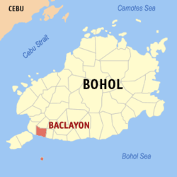 Map of Bohol with Baclayon highlighted | |
.svg.png) Baclayon Location within the Philippines | |
| Coordinates: 9°38′N 123°54′E / 9.63°N 123.9°ECoordinates: 9°38′N 123°54′E / 9.63°N 123.9°E | |
| Country |
|
| Region | Central Visayas (Region VII) |
| Province | Bohol |
| District | 1st District |
| Founded | 1595 |
| Barangays | 17 (see Barangays) |
| Government [1] | |
| • Type | Sangguniang Bayan |
| • Mayor | Benecio Uy |
| • Vice Mayor | Romulo Balangkig |
| • Congressman | Rene Relampagos |
| • Electorate | 12,166 voters (2016) |
| Area [2] | |
| • Total | 34.43 km2 (13.29 sq mi) |
| Population (2015 census)[3] | |
| • Total | 20,591 |
| • Density | 600/km2 (1,500/sq mi) |
| Time zone | UTC+8 (PST) |
| ZIP code | 6301 |
| PSGC | 071205000 |
| IDD : area code | +63 (0)38 |
| Climate type | Tropical monsoon climate |
| Income class | 4th municipal income class |
| Revenue (₱) | 69,770,872.84 (2016) |
| Native languages |
Boholano dialect Cebuano Tagalog |
| Website |
www |
Baclayon, officially the Municipality of Baclayon, (Cebuano: Lungsod sa Baclayon; Tagalog: Bayan ng Baclayon), is a 4th class municipality in the province of Bohol, Philippines. According to the 2015 census, it has a population of 20,591 people.[3]
It is the home town of actor Cesar Montano,[4] and physicist Caesar Saloma.
History
Baclayon was the first municipality to be established in Bohol by the Spaniards and included originally the areas now made up by the municipalities of Alburquerque, Balilihan, Corella, and Sikatuna. Its original name was Bacayan, from the root word bacay, meaning "detour" in reference to the fact that travellers used to make a detour there around a rocky cliff.[5]
In 1595, two Jesuit priests, Juan de Torres and Gabriel Sanchez, arrived in Bohol to convert the local populace to Catholicism. With native help, they built a stone church which is considered as one of the oldest stone churches in the Philippines, and marked the beginning of the town. In 1600, Moros raided the fledgling settlement, which prompted the Jesuits to relocate their residencia to Loboc.[6][7]
In 1717, Baclayon gained status of a parish. In 1742, Tagbilaran was separated from Baclayon, followed by Alburquerque in 1868, Balilihan in 1828, and Corella in 1884.[6]
Barangays
Baclayon comprises 17 barangays:
| PSGC | Barangay | Population | ±% p.a. | |||
|---|---|---|---|---|---|---|
| 2015[3] | 2010[8] | |||||
| 071205003 | Buenaventura | 1.9% | 395 | 426 | −1.43% | |
| 071205001 | Cambanac | 2.0% | 407 | 395 | 0.57% | |
| 071205002 | Dasitam | 3.7% | 752 | 700 | 1.37% | |
| 071205004 | Guiwanon | 7.2% | 1,474 | 1,249 | 3.20% | |
| 071205005 | Landican | 4.2% | 869 | 708 | 3.98% | |
| 071205006 | Laya | 5.2% | 1,068 | 1,001 | 1.24% | |
| 071205007 | Libertad | 6.4% | 1,315 | 1,219 | 1.45% | |
| 071205008 | Montana | 8.3% | 1,719 | 1,613 | 1.22% | |
| 071205009 | Pamilacan | 6.9% | 1,418 | 1,422 | −0.05% | |
| 071205010 | Payahan | 4.5% | 920 | 821 | 2.19% | |
| 071205011 | Poblacion | 9.8% | 2,009 | 1,905 | 1.02% | |
| 071205012 | San Isidro | 4.5% | 919 | 775 | 3.30% | |
| 071205013 | San Roque | 7.2% | 1,478 | 1,424 | 0.71% | |
| 071205014 | San Vicente | 6.1% | 1,249 | 1,130 | 1.92% | |
| 071205015 | Santa Cruz | 9.3% | 1,913 | 1,442 | 5.53% | |
| 071205016 | Taguihon | 9.1% | 1,877 | 1,689 | 2.03% | |
| 071205017 | Tanday | 3.9% | 809 | 711 | 2.49% | |
| Total | 20,591 | 18,630 | 1.92% | |||
Demographics
| Population census of Baclayon | ||
|---|---|---|
| Year | Pop. | ±% p.a. |
| 1903 | 8,055 | — |
| 1918 | 9,000 | +0.74% |
| 1939 | 9,453 | +0.23% |
| 1948 | 8,379 | −1.33% |
| 1960 | 9,050 | +0.64% |
| 1970 | 10,704 | +1.69% |
| 1975 | 10,490 | −0.40% |
| 1980 | 10,776 | +0.54% |
| 1990 | 11,986 | +1.07% |
| 1995 | 12,808 | +1.25% |
| 2000 | 14,996 | +3.44% |
| 2007 | 18,015 | +2.56% |
| 2010 | 18,630 | +1.23% |
| 2015 | 20,591 | +1.92% |
| Source: Philippine Statistics Authority[3] [8] [9] [10] | ||
Tourism
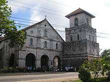
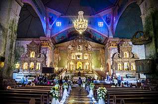
Baclayon is known for its historic Catholic church, declared a National Cultural Treasure in 1995 because it is considered the best preserved of its kind in the region. Its first structure was built in 1595, but the current building is from 1724 and is of Spanish Colonial architecture. The church includes a small museum, with relics dating back to the early 16th century, and adjoining 21-metre (69 ft) high bell tower. Nearby are centuries-old stone buildings like the hermita, and elementary school, as well as the historic public marketplace, a Spanish-era building with giant stone columns supporting the roof.[4][11] In 2013, the church and bell tower were severely damaged by the 2013 Bohol earthquake.
There are 67 or more Spanish colonial ancestral houses in the municipality, many of them along the main road. The houses, in various stages of preservation or neglect, show Spanish-Filipino wooden craftsmanship and styling, some of which were constructed as early as 1853. They are often utilized for cultural shows and tours, festivals and fiestas, as well as some having been turned into inns.[11]
The municipality also has jurisdiction over the dolphin- and whale-watching island of Pamilacan.
See also
References
- ↑ "Municipality". Quezon City, Philippines: Department of the Interior and Local Government. Retrieved 31 May 2013.
- ↑ "Province: Bohol". PSGC Interactive. Quezon City, Philippines: Philippine Statistics Authority. Retrieved 12 November 2016.
- 1 2 3 4 Census of Population (2015). "Region VII (Central Visayas)". Total Population by Province, City, Municipality and Barangay. PSA. Retrieved 20 June 2016.
- 1 2 "What to see and what to do in Bohol, Philippines". www.bohol.ph. 27 January 2011. Retrieved 2012-09-10.
- ↑ "Municipality of Baclayon". Province of Bohol. Retrieved 20 October 2014.
- 1 2 "History of Baclayon". Talibon, Bohol, Philippines: A1 Online Communication and Advertising Services. Retrieved 2012-09-10.
- ↑ Hellingman 2002.
- 1 2 Census of Population and Housing (2010). "Region VII (Central Visayas)". Total Population by Province, City, Municipality and Barangay. NSO. Retrieved 29 June 2016.
- ↑ Censuses of Population (1903–2007). "Region VII (Central Visayas)". Table 1. Population Enumerated in Various Censuses by Province/Highly Urbanized City: 1903 to 2007. NSO.
- ↑ "Province of Bohol". Municipality Population Data. Local Water Utilities Administration Research Division. Retrieved 17 December 2016.
- 1 2 "Baclayon Tourist Attractions". Talibon, Bohol, Philippines: A1 Online Communication and Advertising Services. Retrieved 2012-09-10.
Sources
- Hellingman, Jeroen (4 April 2002). "A Short History of Bohol". www.bohol.ph. Archived from the original on 3 June 2004.
| Wikimedia Commons has media related to Baclayon. |
External links
| Wikivoyage has a travel guide for Baclayon. |
Places adjacent to Baclayon | ||||||||||
|---|---|---|---|---|---|---|---|---|---|---|
| ||||||||||