Panglao Island
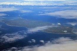 Aerial view of Panglao Island | |
.svg.png) Panglao Island Location within the Philippines .svg.png) Panglao Island Panglao Island (Philippines) | |
| Geography | |
|---|---|
| Location | Bohol Sea |
| Coordinates | 9°36′N 123°49′E / 9.6°N 123.82°ECoordinates: 9°36′N 123°49′E / 9.6°N 123.82°E |
| Area | 91.12 km2 (35.18 sq mi)[1] |
| Length | 16 km (9.9 mi) |
| Width | 7.5 km (4.66 mi) |
| Administration | |
|
Philippines | |
| Region | Central Visayas |
| Province | Bohol |
| Municipalities | |
| Demographics | |
| Population | 79,216 (2015 census)[2] |
| Pop. density | 870 /km2 (2,250 /sq mi) |
Panglao is an island in the north Bohol Sea, located in the Central Visayas region of the Visayas island group, in the south-central Philippines.
Geography
The island has an area of 91.12 square kilometres (35.18 sq mi). It is within Bohol Province, and comprises two municipalities: Dauis and Panglao. Panglao island is located southwest of the island of Bohol and east and south of Cebu.
Panglao has a terrain that ranges from plain, hilly to mountainous. Panglao is made of Maribojoc limestone, the youngest of the limestone units found in the western area of Bohol. The limestone composition halted the development of an airport as coralline limestone is soluble which causes formation of caves and sinkholes. One interesting geological feature found in the island is the Hinagdanan Cave which has an underground water source. The cave is an important water source as the island has no rivers or lakes.
Panglao is a popular tourist destination in the Philippines, and includes several small islands, such as Gak-ang, Pontod, and Balicasag.
According to the 2015 census, it has a population of 79,216.[2]
History
Panglao was known to Chinese, Malay, Siamese and Indonesian traders. It once housed the Kedatuan of Dapitan.
Biodiversity
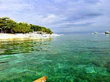
About 250 new species of crustaceans and 2500 new species of mollusks were found around the island. The discovery was the work of the Panglao Marine Biodiversity Project. The project found that Panglao alone has more marine biodiversity than Japan and the Mediterranean sea.[3]
Tourism
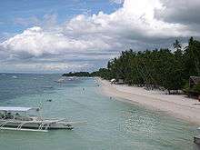
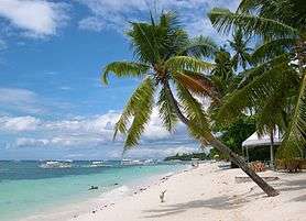
Panglao island is one of the main tourist destinations on the Philippines. Alona Beach is the most popular tourist spot on the island, noted for its white sand and clear water. There are also a lot of attractions to do for tourists such as scuba-diving, island hopping, dolphin watching, snorkeling, kitesurfing and fishing.
Transportation
Panglao Island International Airport is an airport under construction, meant to be the primary international airport to serve the province of Bohol. At three years behind schedule, it is now set to be in operational status at the end of 2018.
The site of the airport is very close to Tagbilaran Airport which currently serves Panglao Island and the rest of Bohol for domestic air travelers. It also is less than 2 hours travel time from Mactan-Cebu International airport, which is a gateway to the Central Philippines for international tourists, although there is no direct flight.
See also
References
- ↑ "Philippine Standard Geographic Code (PSGC) - Province: BOHOL". nap.psa.gov.ph. Philippine Statistics Authority. Retrieved 17 April 2018.
- 1 2 Census of Population (2015). "Region VII (Central Visayas)". Total Population by Province, City, Municipality and Barangay. PSA. Retrieved 20 June 2016.
- ↑ Pedroso, Kate (2 March 2007). "Panglao, Bohol: a center of marine biodiversity". Philippine Daily Inquirer. Archived from the original on 21 February 2013. Retrieved 15 June 2012.
External links
| Wikimedia Commons has media related to Panglao Island. |

- Panglao Island, Bohol - UNESCO World Heritage Centre
- Panglao Island geologically unsafe for airport, experts say