Dumanjug
| Dumanjug | |
|---|---|
| Municipality | |
| Municipality of Dumanjug | |
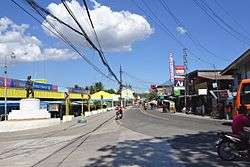 Dumanjug town center | |
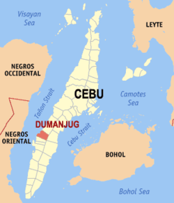 Map of Cebu with Dumanjug highlighted | |
.svg.png) Dumanjug Location within the Philippines | |
| Coordinates: 10°03′N 123°29′E / 10.05°N 123.48°ECoordinates: 10°03′N 123°29′E / 10.05°N 123.48°E | |
| Country |
|
| Region | Central Visayas (Region VII) |
| Province | Cebu |
| District | 7th district of Cebu |
| Founded | 1855 |
| Barangays | 37 (see Barangays) |
| Government [1] | |
| • Type | Sangguniang Bayan |
| • Mayor | Efren Gica |
| • Vice Mayor | Rainero Asentista |
| • Congressman | Peter John Calderon |
| • Electorate | 32,494 voters (2016) |
| Area [2] | |
| • Total | 85.53 km2 (33.02 sq mi) |
| Elevation | 58 m (190 ft) |
| Population (2015 census)[3] | |
| • Total | 51,210 |
| • Density | 600/km2 (1,600/sq mi) |
| Time zone | UTC+8 (PST) |
| ZIP code | 6035 |
| PSGC | 072224000 |
| IDD : area code | +63 (0)32 |
| Climate type | Tropical climate |
| Income class | 3rd municipal income class |
| Revenue (₱) | 126,080,016.34 (2016) |
| Native languages |
Cebuano Tagalog |
| Website |
www |
Dumanjug, officially the Municipality of Dumanjug, (Cebuano: Lungsod sa Dumanjug; Tagalog: Bayan ng Dumanjug), is a 3rd class municipality in the province of Cebu, Philippines. According to the 2015 census, it has a population of 51,210 people.[3]
It was established in 1855.[4] Based on the cadastral survey map of the Department of Environment and Natural Resources (DENR), Dumanjug has an effective land area of 8,544 hectares (21,110 acres)
Dumanjug is bordered to the north by the town of Barili, to the west is the Tañon Strait, to the east is the town of Sibonga, and to the south is the town of Ronda.
Dumanjug is also known as "The Land of Golden Friendship".
Barangays
Dumanjug comprises 37 barangays:
| PSGC | Barangay | Population | ±% p.a. | |||
|---|---|---|---|---|---|---|
| 2015[3] | 2010[5] | |||||
| 072224001 | Balaygtiki | 3.9% | 2,016 | 1,834 | 1.82% | |
| 072224002 | Bitoon | 5.8% | 2,979 | 2,260 | 5.40% | |
| 072224003 | Bulak | 2.8% | 1,441 | 1,419 | 0.29% | |
| 072224004 | Bullogan | 2.1% | 1,065 | 886 | 3.57% | |
| 072224009 | Calaboon | 3.7% | 1,920 | 1,867 | 0.53% | |
| 072224011 | Camboang | 2.3% | 1,194 | 1,123 | 1.17% | |
| 072224012 | Candabong | 1.9% | 982 | 936 | 0.92% | |
| 072224019 | Cogon | 6.0% | 3,051 | 2,768 | 1.87% | |
| 072224021 | Cotcoton | 1.1% | 549 | 457 | 3.55% | |
| 072224006 | Doldol | 3.1% | 1,564 | 1,451 | 1.44% | |
| 072224031 | Ilaya (Poblacion) | 2.4% | 1,217 | 1,103 | 1.89% | |
| 072224007 | Kabalaasnan | 0.8% | 385 | 350 | 1.83% | |
| 072224008 | Kabatbatan | 0.8% | 385 | 320 | 3.58% | |
| 072224010 | Kambanog | 0.9% | 438 | 450 | −0.51% | |
| 072224013 | Kang‑actol | 2.5% | 1,274 | 1,027 | 4.19% | |
| 072224014 | Kanghalo | 1.1% | 559 | 500 | 2.15% | |
| 072224015 | Kanghumaod | 3.2% | 1,642 | 1,579 | 0.75% | |
| 072224016 | Kanguha | 1.5% | 765 | 700 | 1.71% | |
| 072224017 | Kantangkas | 1.6% | 839 | 710 | 3.23% | |
| 072224018 | Kanyuko | 2.1% | 1,088 | 1,074 | 0.25% | |
| 072224020 | Kolabtingon | 1.4% | 740 | 630 | 3.11% | |
| 072224022 | Lamak | 1.1% | 570 | 554 | 0.54% | |
| 072224023 | Lawaan | 4.5% | 2,321 | 2,173 | 1.26% | |
| 072224024 | Liong | 4.2% | 2,159 | 1,746 | 4.13% | |
| 072224025 | Manlapay | 2.6% | 1,307 | 1,675 | −4.61% | |
| 072224026 | Masa | 1.2% | 618 | 528 | 3.04% | |
| 072224027 | Matalao | 0.7% | 341 | 307 | 2.02% | |
| 072224028 | Paculob | 3.1% | 1,576 | 1,582 | −0.07% | |
| 072224029 | Panlaan | 4.3% | 2,190 | 1,857 | 3.19% | |
| 072224030 | Pawa | 2.4% | 1,226 | 972 | 4.52% | |
| 072224039 | Poblacion Central | 1.8% | 938 | 809 | 2.86% | |
| 072224032 | Poblacion Looc | 2.3% | 1,198 | 1,174 | 0.39% | |
| 072224033 | Poblacion Sima | 1.1% | 588 | 503 | 3.02% | |
| 072224034 | Tangil | 5.6% | 2,886 | 2,673 | 1.47% | |
| 072224035 | Tapon | 6.8% | 3,499 | 3,327 | 0.96% | |
| 072224037 | Tubod-Bitoon | 4.2% | 2,129 | 1,905 | 2.14% | |
| 072224038 | Tubod-Dugoan | 3.1% | 1,571 | 1,455 | 1.47% | |
| Total | 51,210 | 46,754 | 1.75% | |||
Demographics
| Population census of Dumanjug | |||||||||||||||||||||||||||||||||||||||||||||||||
|---|---|---|---|---|---|---|---|---|---|---|---|---|---|---|---|---|---|---|---|---|---|---|---|---|---|---|---|---|---|---|---|---|---|---|---|---|---|---|---|---|---|---|---|---|---|---|---|---|---|
|
| ||||||||||||||||||||||||||||||||||||||||||||||||
| Source: Philippine Statistics Authority[3] [5] [6] [7] | |||||||||||||||||||||||||||||||||||||||||||||||||
Dumanjug's population is characterized mainly by an increasing birth rate and a gradually declining mortality rate. The growth in population is thus attributed to higher rate of birth than of death.
The bulk of the household population is concentrated in the coastal barangays located in the western part of the municipality. The urban area comprising Poblacion, Sima, Ilaya, and Looc has the biggest slice of the population. Barangays Bitoon, Tangil, Tapon, Balaygtiki, Cogon and Liong are catching up with the urban barangays in terms of household population. With the urban area fast becoming a commercial hub, Bitoon, Paculob, Cogon and Liong are foreseen as upcoming dormitory communities.
Dumanjuganons speak Cebuano, the official language spoken in Cebu. Cebuano is also spoken in most areas of the Visayas and in many provinces of Mindanao.
Religion
The people of Dumanjug are mostly Catholics. The town has three Catholic parishes:
- St. Francis of Assisi church (Poblacion)
- St. Vincent Ferrer (Bitoon)
- Our Lady of the Holy Rosary (Bulak)
Economy
Majority of the existing industrial establishments in Dumanjug are those of micro-scale industries or establishments. These include bakeshops, welding shops, and cottage industries. Their products are mostly bakery products, assembled vehicles and handicrafts. Most of these establishments are found in the poblacion area and Bitoon. There are also four existing rice and corn mills operating in the municipality.
The municipality has considerable quantities of high-grade dolomite and large phosphate reserves found in Kanghumaod, Balaygtiki, Bullogan, Kabalaasnan, Matalao and Kabatbatan.
The Dumanjug Agora Complex is the center of trade & commerce of the municipality. Within the complex, various commercial establishments contribute greatly to the movement of goods and generation of revenues. These establishments cover basic goods for daily needs to construction supplies, agri-feeds, dry goods and many more. Sunday is designated as market day when various livestock and farm products congregate in the market. Out of town traders create an atmosphere of competition and creating opportunities for local consumers. Opposite the Agora complex is Gaisano Grand Mall, the first mall to be constructed in southwestern Cebu.
Tourist attractions and events
- Pityak / Tubod-Duguan Falls
- Windy Peak Campsite and Cotcoton Loranisa Farm
- SaDumanjugNi Ancestral House
- St. Francis de Assisi Parish Church - one of the oldest church in the Philippines
- Bisnok Festival
- Camoang Marin Sanctuary
- Cantarini Art Gallery
- Dona Josefa Paras Garcia Heritage Park
- Falls of Lelo-an and rock formations
- Julian Macoy photo gallery
- Kota Kanwa Beach
- La Montera Beach Resort
- Monkey Watching at Brangay Kabala-asnan - natural habitat
- The Seaplane
Transportation
Dumanjug is currently served by eight bus operators
- Acop
- Britt
- Caiban Mini-Bus
- Ceres Bus Line
- Chan Transit
- Librando Trans
- Rough Riders
- SM Trans
The municipality also has a RORO (Roll-On Roll Off) port situated in Tangil, which serves as the gateway between southern Cebu and mideastern Negros Island. There are two shipping companies effectively offering round-the-clock service.
Education
Dumanjug has 30 schools offering basic education, six secondary schools, two tertiary education institutions, and two school districts: District I (Dumanjug Central) and District II (Bitoon Central). One of the town's prominent schools, the Little Flower School, was established in 1946 as the Dumanjug branch of the Colegio de San Carlos (now University of San Carlos). It was later renamed as the Dumanjug Catholic High School. It is currently administered by the Oblates of Notre Dame. Dumanjug's biggest school, Bitoon National Vocational School, is in the northern barangay of Bitoon. A satellite campus of the Cebu Technological University is also located in Bitoon.
Elementary Schools - Public Schools
- Balaygtiki Elementary School
- Bitoon Central Elementary School
- Bulak Elementary School
- Bullogan Elementary School
- Calaboon Elementary School
- Cambanog Elementary School
- Camboang Elementary School
- Cogon Elementary School
- Cotcoton Elementary School
- Doldol Elementary School
- Dumanjug Central Elementary School
- Kabalaasnan Elementary School
- Kang-actol Elementary School
- Kanghalo Primary School
- Kanghumaod Elementary School
- Kantangkas Elementary School
- Kanyuko Primary School
- Lamak Primary School
- Lawaan Elementary School
- Manlapay Elementary School
- Masa Elementary School
- Matalao Elementary School
- Paculob Elementary School
- Panlaan Elementary School
- Pawa Elementary School
- Tangil Elementary School
- Tapon Elementary School
- Tubod-Bitoon Elementary School
- Tubod-Dugoan Elementary School
Elementary Schools - Private School
- Little Flower School, Inc.
High Schools - Public Schools
- Bitoon NVHS
- Bulak National High School
- Cogon National High School
- Dumanjug National High School
- Hipolito Boquecosa Memorial National High School
- Tubod Dugoan National High School
Universities or Tertiary Schools - Public Schools
- Cebu Technological University (CTU)
- Bitoon National Vocational School
References
- ↑ "Municipality". Quezon City, Philippines: Department of the Interior and Local Government. Retrieved 31 May 2013.
- ↑ "Province: Cebu". PSGC Interactive. Quezon City, Philippines: Philippine Statistics Authority. Retrieved 12 November 2016.
- 1 2 3 4 Census of Population (2015). "Region VII (Central Visayas)". Total Population by Province, City, Municipality and Barangay. PSA. Retrieved 20 June 2016.
- ↑ Ronaldo S. Tan. "The Beginning of the 'Pueblo' called 'Dumanjug'". History. Municipality of Dumanjug. Archived from the original on 31 October 2015. Retrieved 8 April 2013.
- 1 2 Census of Population and Housing (2010). "Region VII (Central Visayas)". Total Population by Province, City, Municipality and Barangay. NSO. Retrieved 29 June 2016.
- ↑ Censuses of Population (1903–2007). "Region VII (Central Visayas)". Table 1. Population Enumerated in Various Censuses by Province/Highly Urbanized City: 1903 to 2007. NSO.
- ↑ "Province of Cebu". Municipality Population Data. Local Water Utilities Administration Research Division. Retrieved 17 December 2016.
External links

Cebu City (capital) | |
| Municipalities |
|
| Component cities | |
| Highly urbanized cities | (Administratively independent from the province but grouped under Cebu by the Philippine Statistics Authority. However, qualified voters in Mandaue are allowed to vote in elections for Cebu provincial officials as part of the 6th Sangguniang Panlalawigan district.) |