San Francisco, Cebu
| San Francisco | |
|---|---|
| Municipality | |
| Municipality of San Francisco | |
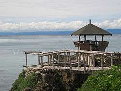 Mangodlong Rock Beach Resort | |
 Map of Cebu with San Francisco highlighted | |
.svg.png) San Francisco Location within the Philippines | |
| Coordinates: 10°39′N 124°21′E / 10.65°N 124.35°ECoordinates: 10°39′N 124°21′E / 10.65°N 124.35°E | |
| Country |
|
| Region | Central Visayas (Region VII) |
| Province | Cebu |
| District | 5th district of Cebu |
| Barangays | 15 (see Barangays) |
| Government [1] | |
| • Type | Sangguniang Bayan |
| • Mayor | Aly Arquillano |
| • Vice Mayor | Allan Arquillano |
| • Congressman | Red Durano |
| • Electorate | 27,484 voters (2016) |
| Area [2] | |
| • Total | 106.93 km2 (41.29 sq mi) |
| Population (2015 census)[3] | |
| • Total | 55,180 |
| • Density | 520/km2 (1,300/sq mi) |
| Time zone | UTC+8 (PST) |
| ZIP code | 6050 |
| PSGC | 072242000 |
| IDD : area code | +63 (0)32 |
| Climate type | Tropical climate |
| Income class | 3rd municipal income class |
| Revenue (₱) | 116,862,176.33 (2016) |
| Native languages |
Porohanon Cebuano Tagalog |
San Francisco, officially the Municipality of San Francisco, (Cebuano: Lungsod sa San Francisco; Tagalog: Bayan ng San Francisco), is a 3rd class municipality in the province of Cebu, Philippines. According to the 2015 census, it has a population of 55,180 people.[3]
It is one of the municipalities that comprise the Camotes Islands.
San Francisco is bordered to the north by the Province of Leyte in the Camotes Sea, to the west is the Camotes Sea Facing Catmon, to the east is the island of Poro with town of Poro and to the south is the Camotes Sea
Geography
San Francisco consists primarily of Pacijan Island (also known as Pajican Island[4]), as well as the tiny Tulang islet just north of Pacijan. Both islands are part of the Camotes Islands group in the Camotes Sea (that also includes Poro Island and Ponson Island). They are located east of the main island of Cebu, south and west of Leyte and north of Bohol.
Pacijan Island is about 14.75 kilometres (9.17 mi) long and 8.5 kilometres (5.3 mi) wide. A 1,400-metre (1,500 yd) causeway crosses the mangrove swamp to connect Pacijan and Poro Island. It was constructed during the Spanish era, to bridge the islands for easier trading and attending services in Poro church.
Barangays
San Francisco comprises 15 barangays:
| PSGC | Barangay | Population | ±% p.a. | |||
|---|---|---|---|---|---|---|
| 2015[3] | 2010[5] | |||||
| 072242002 | Cabunga‑an | 4.0% | 2,226 | 1,764 | 4.53% | |
| 072242003 | Campo | 5.7% | 3,123 | 2,517 | 4.19% | |
| 072242004 | Consuelo | 10.4% | 5,750 | 4,827 | 3.39% | |
| 072242006 | Esperanza | 11.5% | 6,370 | 5,629 | 2.38% | |
| 072242007 | Himensulan | 4.2% | 2,331 | 2,169 | 1.38% | |
| 072242001 | Montealegre | 3.1% | 1,735 | 1,288 | 5.84% | |
| 072242008 | Northern Poblacion | 8.7% | 4,786 | 3,779 | 4.60% | |
| 072242009 | San Isidro | 7.9% | 4,346 | 3,668 | 3.28% | |
| 072242010 | Santa Cruz | 9.9% | 5,465 | 4,717 | 2.84% | |
| 072242011 | Santiago | 4.4% | 2,412 | 2,132 | 2.38% | |
| 072242012 | Sonog | 6.9% | 3,799 | 3,366 | 2.33% | |
| 072242013 | Southern Poblacion | 7.5% | 4,143 | 3,453 | 3.53% | |
| 072242014 | Unidos | 1.8% | 992 | 1,035 | −0.80% | |
| 072242015 | Union | 9.1% | 5,023 | 4,721 | 1.19% | |
| 072242016 | Western Poblacion | 4.9% | 2,679 | 2,292 | 3.02% | |
| Total | 55,180 | 47,357 | 2.95% | |||
Tulang islet
Tulang island (known locally as Tulang Diot) is a five-minute boat ride from Tulang Dako on the main island of Pacijan. Both Tulang Diot and Tulang Dako are part of Esperanza barangay. The islet is almost entirely covered with coconut palms and measures about 1.6 by 0.6 kilometres (1.0 by 0.4 mi): the residential area is confined to a small triangle at the southern end. Total area about 40 ha (100 acres), of which only 3.5 ha (8.6 acres) (8.8%) is inhabited.
Demographics
| Population of San Francisco | |||||||||||||||||||||||||||||||||||||||||||||||||
|---|---|---|---|---|---|---|---|---|---|---|---|---|---|---|---|---|---|---|---|---|---|---|---|---|---|---|---|---|---|---|---|---|---|---|---|---|---|---|---|---|---|---|---|---|---|---|---|---|---|
|
| ||||||||||||||||||||||||||||||||||||||||||||||||
| Source: Philippine Statistics Authority[3][5][6] | |||||||||||||||||||||||||||||||||||||||||||||||||
The town is home to the Porohanon language, one of the most endangered languages in the Visayas. The language is only used in the Poro islands. The language is classified as distinct from Sebwano (Bisaya) by the Komisyon ng Wikang Filipino and is vital to the culture and arts of the Porohanon people.
History
Protohistory
Carl Guthe, director of the University of Michigan Anthropological Museum, during his 1923-25 collecting trip and explorations of archaeological sites in the Philippines,[7] conducted an archeological dig in a cave site on Tulang. Located on the southeastern coast of the island, the cave measures about 3.7 by 2.7 metres (12 by 9 feet). Guthe reported it to contain bone fragments and teeth of about 60 individuals. Associated grave goods included earthenware pottery, shell bracelets, bronze and iron artefacts (iron tang, bronze chisel, iron blade), glass and stone beads, hammerstone and pestle. Filed teeth were also recovered from this site.[lower-alpha 1]
21st century
Just before Typhoon Yolanda struck in November 2013, the mayor of San Francisco ordered the evacuation of all the residents (approximately 1,000) to the main island. This was credited with saving their lives as all houses on the island (about 500) were completely destroyed.[8]
Attractions

Lake Danao
![]()
- Flora
- Corn and coconut grow all over the island, including the areas surrounding the lake. Several rare orchids and a variety of herbs of medicinal value grow along the lake shore.
- Most of the original vegetation has disappeared, and even the small islets in the lake have been planted with coconut palms. The only remaining area of aquatic vegetation is on the east side of the lake, where the water is shallow and there is a dense growth of submerged vegetation, including water cabbage, hydrilla and water hyacinth.
- Soli-soli is a type of grass that grows abundantly along the banks of the lake and is one source of livelihood on the island. These grasses are harvested, dried and woven into different kinds of handicrafts such as bags, mats, hats and other decorative items, and then sold to local and mainland market outlets. An annual festival is held nominally celebrating the plant. This takes place every third Sunday of March, coinciding with the fiesta honoring Saint Joseph. Extending throughout the island, the event is an occupational festival injected with religious sentiments shown through flamboyant colors, abundant food and fervent dancing.
- Fauna
- The lake supports a very rich fishery, and many local residents depend on this resource for their subsistence.
- The rich ichthyofauna includes
- tilapia
- common carp (Cyprinus carpio)
- milkfish (Chanos chanos)
- tank goby (Glossogobius giuris)
- catfish (Clarias sp.)
- A wide variety of avifauna occur including
- little grebe (Tachybaptus ruficollis)
- intermediate egret (Egretta intermedia)
- purple heron (Ardea purpurea)
- wandering whistling duck (Dendrocygna arcuata)
- The estuarine crocodile (Crocodylus porosus) formerly inhabited the lake: according to the Groombridge report (1982),[10] the population was still healthy in 1978, but according to other reports, the last individual was killed in 1971. Monitor lizards (Varanus) can still be seen occasionally on its shore.[11]
Other sights
![]()
![]()
Beaches
![]()
![]()
![]()
Notes
- ↑ Carl Guthe explored 485 sites comprising 120 caves, 134 burial grounds and 231 graves all over the Philippines that are contained in an inventory report now deposited at the University of Michigan.
References
- ↑ "Municipality". Quezon City, Philippines: Department of the Interior and Local Government. Retrieved 31 May 2013.
- ↑ "Province: Cebu". PSGC Interactive. Quezon City, Philippines: Philippine Statistics Authority. Retrieved 12 November 2016.
- 1 2 3 4 Census of Population (2015). "Region VII (Central Visayas)". Total Population by Province, City, Municipality and Barangay. PSA. Retrieved 20 June 2016.
- ↑ Famous Destinations - Camotes group of islands, Cebu Province Official Website. Retrieved on 2010-06-23.
- 1 2 Census of Population and Housing (2010). "Region VII (Central Visayas)". Total Population by Province, City, Municipality and Barangay. NSO. Retrieved 29 June 2016.
- ↑ Censuses of Population (1903–2007). "Region VII (Central Visayas)". Table 1. Population Enumerated in Various Censuses by Province/Highly Urbanized City: 1903 to 2007. NSO.
- ↑ Guthe 1927
- ↑ McElroy 2013
- ↑ Alkuino 2015
- ↑ Groombridge & Wright 1982.
- ↑ Magsalay 2010
Sources
- Alkuino, Xerxes (8 March 2015). "Lake water is suitable for crops". Cebu Provincial Government. Archived from the original on 2 April 2015.
- Groombridge, B. & Wright, L., eds. (1982). The IUCN Amphibia–reptilia Red Data Book. International Union for Conservation of Nature and Natural Resources. Species Survival Commission. ISBN 9782880326012.
- Guthe, Carl E. (1927). "THE UNIVERSITY OF MICHIGAN PHILIPPINE EXPEDITION". American Anthropologist. University of Michigan / Blackwell Publishing Ltd. 29 (1): 69–76. doi:10.1525/aa.1927.29.1.02a00040. ISSN 1548-1433.
- Magsalay, Perla M. (2010). "PHILIPPINES INTRODUCTION - Ramsar Sites Information Service" (PDF). Haribon Foundation. ASEAN Centre for Biodiversity. pp. 36–37. Archived from the original on 15 December 2010.
- McElroy, Andy (15 November 2013). "Evacuation saves whole island from Typhoon Haiyan". United Nations Office for Disaster Risk Reduction. Archived from the original on 19 November 2013.
Places adjacent to San Francisco, Cebu | ||||||||||
|---|---|---|---|---|---|---|---|---|---|---|
| ||||||||||
Cebu City (capital) | |
| Municipalities |
|
| Component cities | |
| Highly urbanized cities | (Administratively independent from the province but grouped under Cebu by the Philippine Statistics Authority. However, qualified voters in Mandaue are allowed to vote in elections for Cebu provincial officials as part of the 6th Sangguniang Panlalawigan district.) |