Negros Island
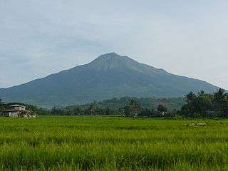 Mount Kanlaon, the highest peak in Negros | |
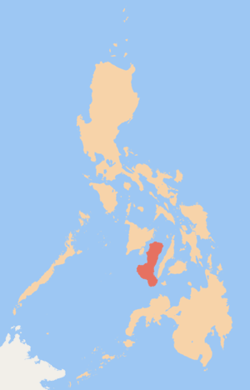 Blank map of the Philippines showing Negros in red | |
| Geography | |
|---|---|
| Location | South East Asia |
| Archipelago | Visayas |
| Adjacent bodies of water | |
| Area | 13,309.60 km2 (5,138.87 sq mi)[1] |
| Area rank | 62nd |
| Coastline | 644.90 km (400.722 mi)[2] |
| Highest elevation | 2,465 m (8,087 ft)[3] |
| Highest point | Kanlaon Volcano |
| Administration | |
| Region | |
| Provinces | |
| Largest settlement | Bacolod (pop. 561,875) |
| Demographics | |
| Demonym | Negrenses/Negrosanons |
| Population | 4,414,131 (2015)[4] |
| Pop. density | 331.7 /km2 (859.1 /sq mi) |
| Ethnic groups | Visayans (Hiligaynons and Cebuanos) |
Negros /ˈneɪɡrɒs/[5] is the fourth largest island of the Philippines, with a land area of 13,309.60 km2 (5,138.87 sq mi).[1] Negros is one of the many islands that comprise the Visayas, which forms the central division of the nation. The predominant inhabitants of the island region are mainly called Negrenses (locally Negrosanons). As of 2015, Negros' total population is 4,414,131 inhabitants.[6]
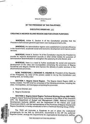
From May 29, 2015 to August 9, 2017, the whole island was governed as an administrative region which was officially named the Negros Island Region which comprised the highly urbanized city of Bacolod and the provinces of Negros Occidental and Negros Oriental, along with its corresponding outlying islands and islets within a total regional area of 13,350.74 km2 (5,154.75 sq mi).[7][8] It was created on May 29, 2015 by virtue of Executive Order No. 183 issued by Benigno Aquino III, who was the president at that time.[9][10] In August 9, 2017, President Rodrigo Duterte signed the Executive Order No. 38 dissolving the Negros Island Region. [11]
History
Precolonial era
Negros was originally called Buglas, an old Hiligaynon word thought to mean "cut off", as it is believed that the island was separated from a larger landmass by rising waters during the last ice age. Among its earliest inhabitants were the dark-skinned Ati people, one of several aboriginal Negrito ethnic groups dispersed throughout Southeast Asia that possesses a unique culture. The westernmost portions of the island soon fell under the nominal rule of the Kedatuan of Madja-as from the neighboring islands of Panay and Guimaras.
Spanish colonization
Upon arriving on the island in April 1565, the Spanish colonizers called the land Negros, after the dark-skinned natives they observed. Two of the earliest native settlements, Binalbagan and Ilog, became towns in 1573 and 1584, respectively, while other settlements of the period included Hinigaran, Bago, Marayo (now Pontevedra), Mamalan (now Himamaylan), and Candaguit (now a sitio of San Enrique). In 1572, King Philip II of Spain conferred the title of Marques de Buglas to the heirs of Juan Sebastián Elcano, the first to circumnavigate the world; the current Marquis is the 17th in line, and resides in Silay, Negros Occidental.
After appointing encomenderos for the island, Miguel López de Legazpi placed Negros under the jurisdiction of the governor of Oton in Panay. In 1734, however, the island became a military district with Ilog as its first capital. The seat of government was later transferred to Himamaylan until Bacolod became the capital in 1849. In 1865, Negros and its outlying minor islands along with Siquijor was converted into a politico-military province.
In 1890, the island was officially partitioned into the present-day provinces of Negros Occidental and Negros Oriental. The Spanish Governor, D. Isidro Castro y Cinceros, surrendered to the Negros Revolutionaries, led by Aniceto Lacson and Juan Araneta, on 6 Nov. 1898.[12]:520 General Miller appointed Aniceto, Governor of the Island in March 1899.[12]:520 On 9 April 1901, the Second Philippine Commission under the chairmanship of William H. Taft arrived in Dumaguete. Weeks later on 1 May, the civil government under American sovereignty was established, and on 28 August, Dr. David S. Hibbard founded what is now Silliman University, with the help of Meliton Larena as the first Mayor of Dumaguete, as well as Demetrio Larena.
Negros Revolution and formation of Republic of Negros

From 3 to 6 November 1898, the Negrense peoples rose in revolt against the local Spanish colonial government headed by politico-military governor Colonel Isidro de Castro. The Spaniards decided to surrender upon seeing armed troops marching in a pincer movement towards Bacolod. The revolutionaries, led by General Juan Araneta from Bago and General Aniceto Lacson from Talisay, bore fake arms consisting of rifles carved out of palm fronds and cannons of rolled bamboo mats painted black. By the afternoon of 6 November, Col. de Castro signed the Act of Capitulation, thus ending centuries of Spanish colonial rule in Negros Occidental.
In memory of this event, every November 5 is observed as a special non-working holiday in the province through Republic Act № 6709, signed by President Corazon Aquino on 10 February 1989.
On 27 November 1898, the Cantonal Republic of Negros unilaterally proclaimed independence, but this was short-lived as the territory became a protectorate of the United States on 30 April 1899. The state was renamed the Republic of Negros (Spanish: República de Negros) on 22 July 1899, and eventually dissolved by the United States and annexed by the U.S. Military Government of the Philippine Islands on 30 April 1901.
The leaders of the short-lived republic were:[13]
- Aniceto Lacson, November 05, 1898 – July 22, 1899 (to November 27, 1898, in Negros Occidental)
- Demetrio Larena, November 24, 1898 – November 27, 1898 (in Negros Oriental)
- President of the Constituent Assembly José Luzuriaga, July 22, 1899 – November 06, 1899
- Secretary of War Juan Araneta
- Civil Governor Melecio Severino, November 06, 1899 – April 30, 1901
- Secretary of Justice Antonio Ledesma Jayme, November 05, 1898 – July 22, 1899
Post-Commonwealth era
Regions were first formed on September 24, 1972 when the provinces of the Philippines were organized into different 11 regions by Presidential Decree No. 1 as part of the Integrated Reorganization Plan of President Ferdinand Marcos. Negros Occidental was assigned to Western Visayas (Region VI) and Negros Oriental was assigned to Central Visayas (Region VII).
Negros Island Region
The movement for a single-island region started in the 1980s when officials of both provinces proposed a one-island, one-region unit. Negros Occidental and Negros Oriental are the only provinces in the Philippines situated in the same island but belonging to two different administrative regions with regional offices located in neighboring Panay and Cebu. The movement to unite the two provinces in Negros island was sustained in the 1990s and 2010s.[14]
The campaign for the creation a region in Negros had gains when President Benigno Aquino III directed the Department of the Interior and Local Government (DILG) to study the establishment of a new region.[15] with the government agency later endorsing the move.[16] NEDA affirmed by saying that its studies show that the proposed region is economically viable.[17]
On May 29, 2015, President Aquino signed Executive Order 183,[18] which created the Negros Island Region. It separated Negros Occidental and its capital Bacolod from Western Visayas (Region VI) and Negros Oriental from Central Visayas (Region VII) to form the island region, which made the total number of regions of the Philippines into 18.[9][10]
Dissolution
On August 9 of 2017, President Rodrigo Duterte signed Executive Order No. 38, revoking the Executive Order No. 183 signed by (former) President Benigno Aquino III on May 29 of 2015, due to the reason of the lack of funds to fully establish the NIR according to Benjamin Diokno, the Secretary of Budget and Management. Its dissolution upset the NIR regional officials and provoked strong negative reactions from the Negrenses.[19]
Demographics

| Population census of Negros | ||
|---|---|---|
| Year | Pop. | ±% p.a. |
| 1990 | 3,182,180 | — |
| 1995 | 3,459,433 | +1.58% |
| 2000 | 3,695,811 | +1.43% |
| 2010 | 4,194,525 | +1.27% |
| 2015 | 4,414,131 | +0.98% |
| Source: Philippine Statistics Authority[4] | ||
Geography
Negros is the second largest island in the Visayas and the fourth largest of the Philippines, with a total land area of 13,309.6 square kilometres (5,138.9 sq mi).[1] It is located between the islands of Panay and Guimaras to the west and Cebu to the east, with Siquijor located on the toe of the island and the islands of Bantayan to the north. Politically and linguistically, Negros is divided into two provinces: Negros Occidental and Negros Oriental.
This division of the island, which roughly follows the mountain range in the center of the island, corresponds to the two linguistic groups. The western half (Occidental) is home to the Ilonggo-speaking population while the eastern half (Oriental) is home to the Cebuano-speaking population. Together, they are all called as Negrenses.
Kanlaon Volcano, located in the central-northern part of the island is the third most-active volcano in the Philippines and overlooks bordering communities and the city of Bacolod to the west. It is the highest peak of the whole island and of the Visayas. Other notable peaks on the island are Mount Silay and Mount Mandalagan in Negros Occidental and Mount Talinis (also known as Cuernos de Negros) in Negros Oriental. There are also lakes that dot the island, among the most notable are the Balinsasayao Twin Lakes in Negros Oriental.
The volcanic activity in Negros is harnessed into electricity through two geothermal power plants in the island. One is located in Palinpinon of Valencia in Negros Oriental and the other is in Mailum of Bago City in Negros Occidental, but was eventually shut down.
Administrative divisions
The island of Negros is composed of 2 provinces, 1 highly urbanized city, 18 component cities, 38 municipalities and 1,219 barangays. Negros Occidental is designated as part of Western Visayas and Negros Oriental is designated as part of Central Visayas.

| Province or HUC | Capital | Population (2015)[4] | Area[20] | Density | Cities | Muni. | Bgy. | ||||||
|---|---|---|---|---|---|---|---|---|---|---|---|---|---|
| km2 | sq mi | /km2 | /sq mi | ||||||||||
| Negros Occidental | Bacolod | 56.6% | 2,497,261 | 7,802.54 | 3,012.58 | 320 | 830 | 12 | 19 | 601 | |||
| Negros Oriental | Dumaguete | 30.7% | 1,354,995 | 5,385.53 | 2,079.36 | 250 | 650 | 6 | 19 | 557 | |||
| Bacolod | † | — | 12.7% | 561,875 | 162.67 | 62.81 | 3,500 | 9,100 | — | — | 61 | ||
| Total | 4,414,131 | 13,350.74 | 5,154.75 | 330 | 850 | 19 | 38 | 1,219 | |||||
|
† Bacolod is a highly-urbanized city; figures are excluded from Negros Occidental. | |||||||||||||

Bacolod is the most populous city on the island and the center of the Bacolod Metropolitan Area (which also contains the cities of Talisay and Silay), as well as the 19th most populous city of the whole Philippines, while Dumaguete is the most densely populated city in the whole region.
Negros Occidental has the most chartered cities amongst all the provinces in the Philippines. The province comprises 13 cities and 19 municipalities, which are further subdivided into 601 barangays. Although Bacolod serves as the capital, it is governed independently from its corresponding province as a highly urbanized city. Negros Oriental comprises 6 cities and 19 municipalities, with 557 barangays.
| City | Population (2015)[4] | Area[21] | Density | City class | Income class | Province | ||
|---|---|---|---|---|---|---|---|---|
| km2 | sq mi | /km2 | /sq mi | |||||
| Bacolod | 561,875 | 162.67 | 62.81 | 3,500 | 9,100 | Highly urbanized | 1st | Negros Occidental |
| Bago | 170,981 | 401.20 | 154.90 | 430 | 1,100 | Component | 2nd | Negros Occidental |
| Bais | 76,291 | 319.64 | 123.41 | 240 | 620 | Component | 3rd | Negros Oriental |
| Bayawan | 117,900 | 699.08 | 269.92 | 170 | 440 | Component | 2nd | Negros Oriental |
| Cadiz | 154,723 | 524.57 | 202.54 | 290 | 750 | Component | 2nd | Negros Occidental |
| Canlaon | 54,509 | 170.93 | 66.00 | 320 | 830 | Component | 4th | Negros Oriental |
| Dumaguete | 131,377 | 33.62 | 12.98 | 3,900 | 10,000 | Component | 2nd | Negros Oriental |
| Escalante | 94,070 | 192.76 | 74.43 | 490 | 1,300 | Component | 4th | Negros Occidental |
| Guihulngan | 95,969 | 388.56 | 150.02 | 250 | 650 | Component | 5th | Negros Oriental |
| Himamaylan | 106,880 | 367.04 | 141.71 | 290 | 750 | Component | 3rd | Negros Occidental |
| Kabankalan | 181,977 | 697.35 | 269.25 | 260 | 670 | Component | 1st | Negros Occidental |
| La Carlota | 64,469 | 137.29 | 53.01 | 470 | 1,200 | Component | 4th | Negros Occidental |
| Sagay | 146,264 | 330.34 | 127.54 | 440 | 1,100 | Component | 3rd | Negros Occidental |
| San Carlos | 132,536 | 451.50 | 174.33 | 290 | 750 | Component | 2nd | Negros Occidental |
| Silay | 126,930 | 214.80 | 82.93 | 590 | 1,500 | Component | 3rd | Negros Occidental |
| Sipalay | 70,070 | 379.78 | 146.63 | 180 | 470 | Component | 4th | Negros Occidental |
| Talisay | 102,214 | 201.18 | 77.68 | 510 | 1,300 | Component | 4th | Negros Occidental |
| Tanjay | 80,532 | 276.05 | 106.58 | 290 | 750 | Component | 4th | Negros Oriental |
| Victorias | 87,933 | 133.92 | 51.71 | 660 | 1,700 | Component | 4th | Negros Occidental |
Transportation
Both provinces of Negros are interconnected by major inter-provincial roads. In Bacolod, there are two main roads, namely Lacson Street to the north and Araneta Street to the south. Cities, especially the provincial capitals of Bacolod and Dumaguete, are being served by jeepneys and taxis. Tricycles are mainly used for short-distance travel, and is common in city barangays, smaller cities and towns. Bus stations are present in major cities and towns within the region. Vallacar Transit Corporation, which operates the Ceres buses, serves the whole island of Negros. There are regularly scheduled fast ferry and roll-on/roll-off services for the island region's coastal cities and towns.
Airports
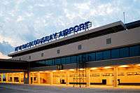
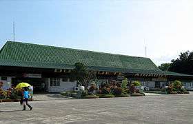
Currently, there are two airports serving Negros island. The Bacolod-Silay International Airport, located in the city of Silay, serves the general area of Bacolod Metropolitan Area, and is expected to become the primary international gateway to Negros. The Dumaguete-Sibulan Airport, located in the town of Sibulan, serves the general area of Dumaguete and its neighbouring towns. However, a new airport is being planned to be constructed in the town of Bacong, south of Dumaguete, to replace the older airport in Sibulan.[22]
International
Domestic
- Dumaguete-Sibulan Airport
- Kabankalan Airport (under construction)
- Sipalay Airport
Economy

Negros is noted for being the nation's prime producer and exporter of sugar. Sugarcane plantations abound in the agricultural areas of the island. The island also produces cotton and hardwood. Sugar is the biggest industry in the island, followed by organic agricultural products and gamefowl breeding.[23] Its principal sugar-growing region is located in the north and west of the island, stretching from northwest along the coasts of the Visayan Sea and Guimaras Strait, which is one of the nation's principal lowland areas in the Visayas. Negros is now aiming to be the prime producer of organic agricultural produce in Asia.[24][25]
Sugar refining has many by-products such as acetylene, fertilizers and rum. Fishing is the major industry based in Cadiz City. There are also a number of fishponds and prawn farming has become a major industry. Bacolod City is the center of commerce and finance in Negros. It is where oil companies, factories, bottling plants, allied industrial businesses, steel fabrication, power generation, agri-businesses, prawn culture and other aqua-culture ventures are found.[26] By November 2016, Negros generated a total net worth of ₱36.65 billion,[27] making it the 2nd-richest region of the Visayas (after Central Visayas) and the 5th-richest of the whole Philippines.
Tourism


Negros has a lot of tourist attractions. In the city of Silay alone, there are 30 ancestral houses, amongst the most notable is the Balay Negrense. Festivals are also a major tourist attraction in Negros, among the most notable, is the Masskara Festival in the city of Bacolod, which is celebrated during the third week of October, as well as Buglasan Festival in the city of Dumaguete, also held in October.[28] Museums showcase the culture, history and people of Negros, with one example being the Negros Museum, situated behind the Negros Occidental Provincial Capitol Complex.[29] Murcia and Salvador Benedicto offer experiences in inland Negros Occidental,[30] the former being known for its Mambukal Resort, while the latter serves as the "Summer Capital of Negros Occidental". Kanlaon Volcano, as well as many other neighbouring peaks, are popular amongst mountain climbers and hikers visiting Negros. The town of Pulupandan, situated in the western tip of Negros, is becoming popular to bird-watching enthusiasts. thanks to its new bird-watching sanctuary.[31]
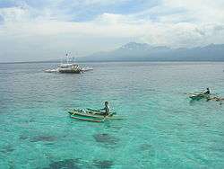
When it comes to beaches and coastal resorts within the region, the most popular ones are Lakawon Island in Cadiz City, Jomabo Island in Escalante City, Sipaway/Refugio Island in the city of San Carlos, Sipalay City, Hinoba-an and Manjuyod's sand bar. The top attractions in Cauayan are the Punta Bulata White Beach Resort and Danjugan Island, which serves as a major diving spot in Negros Occidental. Also, a marine reserve is established in Sagay City, which protects the marine life and reefs of Carbin and Maca, making it a popular draw for marine life enthusiasts. Dauin is known for its beach resorts and Apo Island, a famous diving spot and marine reserve in Negros Oriental. The city of Dumaguete is popular amongst students, largely because of its presence as a university city in the region. Bais City has since then become a tourist spot for whale and dolphin watching,[32] due to its coastline touching the Tañon Strait. Antulang Beach Resort and Tambobo Bay, as well as the inland Lake Balanan serve as three important attractions in the town of Siaton. Situated within the towns of Sibulan, San Jose and Valencia is the Balinsasayao Twin Lakes Natural Park, which serves as an important draw for tourists going to inland Negros Oriental.
Energy
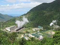
The island is known for using geothermal energy to provide electricity for its inhabitants. In San Carlos, Negros Occidental where energy company San Carlos Solar Energy (SaCaSol) is located, solar energy is being used to power the city and surrounding municipalities.[33] Inland towns and cities of Negros uses hydroelectric power acquired from springs, rivers and waterfalls. Due to the island region's sugarcane-based agriculture, Negros may become the nation's major biofuel producer, with sugarcane being used for ethanol extraction.[34]
Endangered species
Negros, like the Central Philippines (Visayas) overall, is generally recognized as a top priority area for wildlife conservation, both in terms of numbers of endemic species and severity of threat. More than half of the critically endangered species listed in the Philippines occurs in Negros. It is the most threatened area of the Philippines, since it has the least remaining forest cover and the highest numbers of severely threatened endemic species and subspecies. Mt. Silay and Mt. Mandalagan are the two mountain peaks in the Northern Negros Natural Park. These mountains have old-growth forests. Threatened species recorded in this area include the white-winged cuckooshrike, Visayan flowerpecker, flame-templed babbler, writhed-billed hornbill, Visayan tarictic hornbill, rufous-lored kingfisher, blue-naped parrot and Philippine hawk-eagle.[35]
References
- 1 2 3 "2010 Philippine Yearbook" (PDF) (23rd ed.). Manila, Philippines: Philippine Statistics Authority. ISSN 0116-1520. Retrieved 2015-12-14.
- ↑ "Islands of Philippines". Island Directory. United Nations Environment Programme. Retrieved 18 September 2015.
- ↑ "Kanlaon Volcano". www.phivolcs.dost.gov.ph. Philippine Institute of Volcanology and Seismology. Retrieved 18 September 2015.
- 1 2 3 4 Census of Population (2015). Highlights of the Philippine Population 2015 Census of Population. PSA. Retrieved 20 June 2016.
- ↑ "Negros". Oxford Dictionaries. Retrieved 19 September 2017.
- ↑ Census of Population (2015). Highlights of the Philippine Population 2015 Census of Population. PSA. Retrieved 20 June 2016.
- ↑ Bueza, Michael (June 5, 2015). "FAST FACTS: The Negros Island Region". Rappler. Retrieved June 21, 2015.
- ↑ Bustillo, Roy (June 20, 2015). "Negros Island Region is now Region XVIII". CNN Philippines. Retrieved June 21, 2015.
- 1 2 "Aquino OKs creation of Negros Island Region". Philippine Daily Inquirer. June 5, 2015. Retrieved June 5, 2015.
- 1 2 "PNoy joins 2 Negros provinces into one region". ABS-CBNnews.com. June 5, 2015. Retrieved June 21, 2015.
- ↑ n/a (August 9, 2017). "BREAKING: President Rodrigo Duterte issues E.O. 38, which revokes the creation of Negros Island Region". CNN Philippines. Retrieved August 9, 2017.
- 1 2 Foreman, J., 1906, The Philippine Islands, A Political, Geographical, Ethnographical, Social and Commercial History of the Philippine Archipelago, New York: Charles Scribner's Sons
- ↑ "World Statesmen - Philippines - Republic of Negros". Retrieved May 18, 2017.
- ↑ "What Went Before: A history of splits and mergers". Philippine Daily Inquirer. May 19, 2015. Retrieved June 21, 2015.
- ↑ "One Negros dream: Aquino won't commit, points to Roxas". Philippine Daily Inquirer. May 27, 2014. Retrieved June 21, 2015.
- ↑ Gomez, Carla (January 6, 2015). "PNoy okay of island region seen". Visayan Daily Star. Retrieved June 21, 2015.
- ↑ "NEDA: Negros Occ can survive if separated from WV". The Freeman. The Philippine Star. April 19, 2015. Retrieved June 21, 2015.
- ↑ "Executive Order No. 183, s. 2015". Official Gazette. Retrieved 12 October 2015.
- ↑ "Negrenses upset over Duterte's order dissolving Negros region". Sun.Star. August 9, 2017. Retrieved August 9, 2017.
- ↑ "PSGC Interactive; List of Provinces". Philippine Statistics Authority. Retrieved 29 March 2016.
- ↑ "PSGC Interactive; List of Cities". Philippine Statistics Authority. Retrieved 29 March 2016.
- ↑ "To a new site in Bacong town Solon wants to relocate airport from Dumaguete". The Philippine Star. November 19, 2014. Retrieved May 17, 2017.
- ↑ "Bird Flu Alert In Negros". Sun.Star. Retrieved 2014-01-25.
- ↑ Juan, Chit (July 13, 2015). "Is Negros Island the organic bowl of Asia?". The Manila Times.
- ↑ "Agrilink 2016 to Highlight Potentials of Negros Island Region's Organic Agriculture". Agrilink. September 20, 2016.
- ↑ "About Negros Occidental - Negros Occidental Provincial Government". www.negros-occ.gov.ph. Retrieved 2016-02-14.
- ↑ "2 Negros provinces among richest in Philippines". Sun.Star. Retrieved 2016-11-05.
- ↑ "Buglasan Festival of Negros Oriental". Official Website of the City of Dumaguete. Retrieved May 16, 2017.
- ↑ Piccio, Belle (July 24, 2013). "The Negros Museum: A Quick Way to Get to Know the Island of Negros".
- ↑ "Beat The Summer Heat in Negros". Sun.Star. May 12, 2017.
- ↑ "Pulupandan: A New Birdwatching Sanctuary". February 4, 2012.
- ↑ "Dolphin Watching at Bais City, Negros Oriental". October 16, 2012.
- ↑ Official Website of SaCaSol
- ↑ Espina, Rolly (2 May 2006). "Negros may become biofuel center source". The Philippine Star. Retrieved 10 September 2016.
- ↑ Developing Field Research Priorities in Negros Island (West Visayas, Philippines) with particular reference to key threatened endemic species, September 2008, by Bristol Clifton and West of England Zoological Society Fauna and Flora International – Philippines Biodiversity Conservation Programme Philippines Biodiversity Conservation Foundation, Inc.
External links
| Wikimedia Commons has media related to Negros Island. |
| Wikivoyage has a travel guide for Negros. |
- Official Website of the Provincial Government of Negros Occidental
- Official Website of the Provincial Government of Negros Oriental

