Alicia, Bohol
| Alicia | ||
|---|---|---|
| Municipality | ||
| Municipality of Alicia | ||
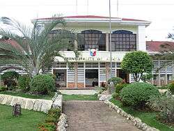 Municipality Hall | ||
| ||
 Map of Bohol with Alicia highlighted | ||
.svg.png) Alicia Location within the Philippines | ||
| Coordinates: 9°54′N 124°27′E / 9.9°N 124.45°ECoordinates: 9°54′N 124°27′E / 9.9°N 124.45°E | ||
| Country |
| |
| Region | Central Visayas (Region VII) | |
| Province | Bohol | |
| District | 3rd District | |
| Founded | 18 January 1950 | |
| Barangays | 15 (see Barangays) | |
| Government [1] | ||
| • Type | Sangguniang Bayan | |
| • Mayor | Marnilou Ayuban | |
| • Vice Mayor | Victoriano Torres | |
| • Congressman | Arthur Yap | |
| • Electorate | 13,423 voters (2016) | |
| Area [2] | ||
| • Total | 114.50 km2 (44.21 sq mi) | |
| Population (2015 census)[3] | ||
| • Total | 23,517 | |
| • Density | 210/km2 (530/sq mi) | |
| Time zone | UTC+8 (PST) | |
| ZIP code | 6314 | |
| PSGC | 071202000 | |
| IDD : area code | +63 (0)38 | |
| Climate type | Tropical monsoon climate | |
| Income class | 4th municipal income class | |
| Revenue (₱) | 75,012,399.32 (2016) | |
| Native languages |
Boholano dialect Cebuano Tagalog | |
| Patron saint | Joachim | |
| Website |
www | |

Alicia, officially the Municipality of Alicia, (Cebuano: Lungsod sa Alicia; Tagalog: Bayan ng Alicia), is a 4th class municipality in the province of Bohol, Philippines. According to the 2015 census, it has a population of 23,517 people.[3]
Located 103 kilometres (64 mi) from Tagbilaran, it was formerly part of Mabini and was known as Batuanan (or Batuanon).[4][5]
Alicia celebrates its town fiesta on 26 July in honor of Saint Joachim.
History
In the mid-19th century Alicia was one of the three largest and oldest towns of Bohol along with Catigbian and Balilihan. The town was where former followers of Dagohoy were given some land to till, but at the same time could be kept under the watchful eye of Spanish authorities.
In 1829, the year the Dagohoy Rebellion ended, the town was the largest of five such settlements, with over 6000 inhabitants.
In 1949, it became an independent municipality, which was renamed Alicia after Alicia Syquia, the wife of president Elpidio Quirino. She and three of their children were massacred by the Japanese in 1945.
Barangays
Alicia comprises 15 barangays:
| PSGC | Barangay | Population | ±% p.a. | |||
|---|---|---|---|---|---|---|
| 2015[3] | 2010[6] | |||||
| 071202001 | Cabatang | 3.7% | 861 | 675 | 4.74% | |
| 071202002 | Cagongcagong | 1.9% | 440 | 423 | 0.75% | |
| 071202003 | Cambaol | 5.2% | 1,216 | 1,087 | 2.16% | |
| 071202004 | Cayacay | 8.1% | 1,897 | 1,713 | 1.96% | |
| 071202005 | Del Monte | 3.5% | 834 | 806 | 0.65% | |
| 071202006 | Katipunan | 9.9% | 2,317 | 2,230 | 0.73% | |
| 071202007 | La Hacienda | 16.0% | 3,758 | 3,710 | 0.25% | |
| 071202008 | Mahayag | 2.9% | 681 | 687 | −0.17% | |
| 071202009 | Napo | 5.5% | 1,295 | 1,255 | 0.60% | |
| 071202010 | Pagahat | 3.2% | 747 | 586 | 4.73% | |
| 071202011 | Poblacion (Calingganay) | 17.9% | 4,214 | 4,064 | 0.69% | |
| 071202012 | Progreso | 4.4% | 1,031 | 1,019 | 0.22% | |
| 071202013 | Putlongcam | 7.2% | 1,698 | 1,578 | 1.41% | |
| 071202014 | Sudlon (Omhon) | 2.8% | 656 | 648 | 0.23% | |
| 071202015 | Untaga | 8.0% | 1,872 | 1,804 | 0.71% | |
| Total | 23,517 | 22,285 | 1.03% | |||
Demographics
| Population census of Alicia | ||
|---|---|---|
| Year | Pop. | ±% p.a. |
| 1960 | 11,860 | — |
| 1970 | 12,717 | +0.70% |
| 1975 | 14,770 | +3.05% |
| 1980 | 15,766 | +1.31% |
| 1990 | 18,653 | +1.70% |
| 1995 | 19,402 | +0.74% |
| 2000 | 21,605 | +2.33% |
| 2007 | 23,422 | +1.12% |
| 2010 | 22,285 | −1.79% |
| 2015 | 23,517 | +1.03% |
| Source: Philippine Statistics Authority[3] [6] [7] [8] | ||
Mayors
-
- Pedro Huiso1950–1955
- Exequiel Madriñan
- Leoncio Garcia1956–1959
- Jesus Madriñan1960–1980
- Dominador Molina1980–1987
- Exequiel Madriñan Jr1988–1995
- Basilio Balahay1995–2001
- Bienvenido Molina2001–2007
- Pedro Miasco2007–2010
- Marnilou Ayuban2010–
Gallery
 Poblacion and public market
 Plaza and town hall
 Residential street in Alicia
 Church
References
- ↑ "Municipality". Quezon City, Philippines: Department of the Interior and Local Government. Retrieved 31 May 2013.
- ↑ "Province: Bohol". PSGC Interactive. Quezon City, Philippines: Philippine Statistics Authority. Retrieved 12 November 2016.
- 1 2 3 4 Census of Population (2015). "Region VII (Central Visayas)". Total Population by Province, City, Municipality and Barangay. PSA. Retrieved 20 June 2016.
- 1 2 "Historical Sketch of the Municipality of Alicia". Municipality of Alicia. Retrieved 2012-09-07.
- ↑ Tirol, Jes. Establishment of Batuanan town, its abolition and re-establishment as Alicia town Archived 2007-09-28 at the Wayback Machine.
- 1 2 Census of Population and Housing (2010). "Region VII (Central Visayas)". Total Population by Province, City, Municipality and Barangay. NSO. Retrieved 29 June 2016.
- ↑ Censuses of Population (1903–2007). "Region VII (Central Visayas)". Table 1. Population Enumerated in Various Censuses by Province/Highly Urbanized City: 1903 to 2007. NSO.
- ↑ "Province of Bohol". Municipality Population Data. Local Water Utilities Administration Research Division. Retrieved 17 December 2016.
| Wikimedia Commons has media related to Alicia. |