Lubang Island
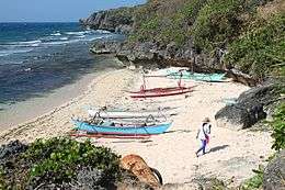 One of the beaches in Lubang island | |
.svg.png) Lubang Island Location within the Philippines | |
| Geography | |
|---|---|
| Coordinates | 13°46′3″N 120°11′10″E / 13.76750°N 120.18611°ECoordinates: 13°46′3″N 120°11′10″E / 13.76750°N 120.18611°E |
| Archipelago | Lubang Group of Islands |
| Adjacent bodies of water | |
| Area | 125 km2 (48 sq mi) |
| Administration | |
| Region | MIMAROPA |
| Province | Occidental Mindoro |
| Municipalities | |
| Demographics | |
| Population | 28,922 (as of 2015) |
Lubang Island is the largest island in the Lubang Group of Islands, an archipelago which lies to the northwest of the northern end of Mindoro in the Philippines. The Lubang Islands are about 150 kilometres (93 mi) southwest of Manila. There are seven islands in the group,[1] The island is divided into two municipalities. The largest settlement is the town of Lubang, the northwest end of the island. Its town center is about 8 miles (13 km) northwest of Tilik Port, the only safe anchorage on Lubang Island.[2] The southeastern half of the island is covered by the Municipality of Looc. The Lubang island group, which constitutes all the 7 islands, are geographically distinct from any landmass, making it biologically unique - and endangered at the same time. The islands are under consideration to be set as a UNESCO tentative site.[3]
Geography
Northwest to southeast the four main islands are Cabra Island, separated by a deep, 3-kilometre (1.9 mi) wide channel from Lubang Island, then Ambil Island and finally Golo Island. The three smaller islands are Talinas Island, Malavatuan Island and Mandaui Island.[1]
- Cabra Island is mostly wooded and about 3 kilometres (1.9 mi) long, rising to a height of about 60 metres (200 ft). It has a lighthouse at the northwest end of the island.[1][2]
- Lubang Island is about 125 square kilometres (48 sq mi), being over 25 kilometres (16 mi) in length and up to 10 kilometres (6.2 mi) wide.[1] It is the 34th largest island in the Philippine archipelago.
- Ambil Island is an extinct volcanic island rising to over 760 metres (2,490 ft) and is about 26 square kilometres (10 sq mi) in area.[1] During the earlier part of the Spanish Colonial Era, Ambil was reported to be in eruption.[4] But when it was climbed by German scientist Carl Semper in the latter part of 19th century, he found no evidence that it has erupted in historical times.[5] It is the 93rd largest island in the Philippine archipelago.
- Golo Island is long, narrow and flat lying, and is about 26 square kilometres (10 sq mi) in area.[1]
History
The islands were originally settled by an ethnic group from the Visayan. By 1900 the islands were inhabited by both Tagalog and Visayan people.[1]
The Spanish built a fort on Lubang Island, the San Vicente Bastion, on the western point of the entrance to Tilik Port.
After World War II, Lubang Island was where Hiroo Onoda, a Japanese army intelligence officer, hid in the jungles when the Allies reclaimed the Philippines. He engaged in continuous, and sometimes deadly, guerrilla warfare against the United States and later against Philippine Commonwealth troops and paramilitary police. Despite flyers being dropped by airplanes in his hiding area, he adamantly believed that the war was not over yet. In March 1974, he was officially relieved of duty, 29 years after the end of the war, making him one of the last Japanese soldiers to surrender.[6] An independent documentary titled Search For Onoda is currently in production. The documentary was shot on location around Vigo, Burol, Agkawayan and Looc.[7]
Administration
The islands are administratively part of the province of Occidental Mindoro and are divided into two municipalities: Lubang and Looc. Lubang covers the northwestern half of Lubang Island (Cabra Island included), while Looc covers the remaining half of Lubang Island plus Ambil, Golo and the other islands. Looc Proper is divided into three major sections: BonBon, Gitna and Kanluran. These islands offer scenic delights, pristine waters, abundant and precious marine life, and scuba-diving opportunities. The coast lines boasts of white sand and unspoiled beauty.
Economics
Most of the population resides on Lubang Island, where Tilik Port is located. The main economic activity is fishing in the waters surrounding the islands and planting rice, garlic, peanut and vegetables. However, with the islands fine white-sand coastlines, tourism is growing in economic importance.
Notes
- 1 2 3 4 5 6 7 Landor, Arnold Henry Savage (1904). The Gems of the East: Sixteen Thousand Miles of Research Travel Among Wild and Tame Tribes of Enchanting Islands, p. 10. Harper & Bros., New York. OCLC 1688191
- 1 2 Dow, John C. (1906). Philippine Islands Sailing Directions: Section II: Southwest and South Coasts of Luzon and Adjacent Islands from Manila to San Bernardino Straits (third edition), pp 19–20. U.S. Coast and Geodetic Survey, Manila.
- ↑ https://www.researchgate.net/publication/227765006_Taxonomy_of_wild_pigs_Sus_of_the_Philippines
- ↑ Daubeny, Charles (1848). "A description of active and extinct volcanos, of earthquakes, and of thermal springs", p.399. Richard and John E. Taylor, London.
- ↑ Becker, George F. (1901). "Report of the Geology of the Philippines", p.53. Government Printing Office, Wachington.
- ↑ Trefalt, Beatrice (1999) "A Straggler Returns: Onoda Hirō and Japanese Memories of the War" War & Society 17(2): pp. 111–124, doi:10.1179/072924799791201470
- ↑ http://searchforonoda.com
References
- Hiroo Onoda (1974) No Surrender: My Thirty-Year War Kodansha International, New York, ISBN 0-87011-240-6