Whetstone Mountain
| Whetstone Mountain | |
|---|---|
 | |
| Highest point | |
| Elevation | 12,527 ft (3,818 m) [1][2] |
| Prominence | 2,456 ft (749 m) [3] |
| Isolation | 9.39 mi (15.11 km) [3] |
| Listing | Colorado prominent summits |
| Coordinates | 38°49′20″N 106°58′48″W / 38.8223016°N 106.9798991°WCoordinates: 38°49′20″N 106°58′48″W / 38.8223016°N 106.9798991°W [1] |
| Geography | |
 Whetstone Mountain | |
| Location |
Gunnison County, Colorado, United States[4] |
| Parent range | West Elk Mountains[3] |
| Topo map |
USGS 7.5' topographic map Crested Butte, Colorado[1] |
| Climbing | |
| Easiest route | hike |
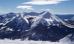
Whetstone Mountain, elevation 12,527 ft (3,818 m), is a summit in the Gunnison National Forest of western Colorado. The mountain is located 3 mi (4.8 km) south of Crested Butte in Gunnison County. Whetstone Mountain is one of several prominent laccoliths found in the West Elk Mountains.
Historical names
- Wheatstone Mountain
- Whetstone Mountain – 1927 [4]
See also
References
- 1 2 3 "WHETSTONE MTN CAIRN". NGS data sheet. U.S. National Geodetic Survey. Retrieved October 23, 2014.
- ↑ The elevation of Whetstone Mountain includes an adjustment of +1.922 m (+6.31 ft) from NGVD 29 to NAVD 88.
- 1 2 3 "Whetstone Mountain, Colorado". Peakbagger.com. Retrieved October 23, 2014.
- 1 2 "Whetstone Mountain". Geographic Names Information System. United States Geological Survey. Retrieved November 14, 2014.
External links

This article is issued from
Wikipedia.
The text is licensed under Creative Commons - Attribution - Sharealike.
Additional terms may apply for the media files.