Berrian Mountain
| Berrian Mountain | |
|---|---|
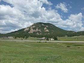 Berrian Mountain seen from Meyer Ranch Park. | |
| Highest point | |
| Elevation | 9,151 ft (2,789 m) [1][2] |
| Prominence | 927 ft (283 m) [2] |
| Isolation | 4.90 mi (7.89 km) [2] |
| Coordinates | 39°33′18″N 105°17′32″W / 39.5549883°N 105.2922146°WCoordinates: 39°33′18″N 105°17′32″W / 39.5549883°N 105.2922146°W [3] |
| Geography | |
 Berrian Mountain | |
| Location | Jefferson County, Colorado, U.S.[3] |
| Parent range | Front Range[2] |
| Topo map |
USGS 7.5' topographic map Conifer, Colorado[3] |
| Climbing | |
| First ascent | 1879 |
| Easiest route | North-western face across Denver Mountain Parks open space |
Berrian Mountain is a mountain summit in the Front Range of the Rocky Mountains of North America. The 9,151-foot (2,789 m) peak is located 0.9 miles (1.5 km) north-northeast (bearing 17°) of the community of Aspen Park in Jefferson County, Colorado, United States.[1][2][3]
Mountain
According to Jefferson County Archives, Berrian Mountain was named after George, Dan, and Ray Berrian and the Berrian family who came from Kansas to Colorado in 1887. Previously, it may have been called McIntyre Mountain after Duncan McIntyre, who owned property on the east side of the mountain where Midway House is located.
November 1, 1981, at 8:03 p.m. MST, a magnitude 3.1 tremor centered on Berrian Mountain.
See also
References
- 1 2 The elevation of Berrian Mountain includes an adjustment of +1.163 m (+3.82 ft) from NGVD 29 to NAVD 88.
- 1 2 3 4 5 "Berrian Mountain, Colorado". Peakbagger.com. Retrieved October 19, 2014.
- 1 2 3 4 "Berrian Mountain". Geographic Names Information System. United States Geological Survey. Retrieved October 19, 2014.
External links

This article is issued from
Wikipedia.
The text is licensed under Creative Commons - Attribution - Sharealike.
Additional terms may apply for the media files.