Mount Lindsey
| Mount Lindsey | |
|---|---|
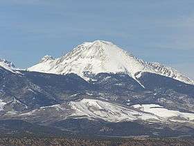 Mt. Lindsey as seen from U.S. Route 160. | |
| Highest point | |
| Elevation | 14,048 ft (4,282 m) [1][2] |
| Prominence | 1,542 ft (470 m) [2] |
| Isolation | 2.26 mi (3.64 km) [2] |
| Listing | Colorado Fourteener 43rd |
| Coordinates | 37°35′05″N 105°26′27″W / 37.5847273°N 105.4408433°WCoordinates: 37°35′05″N 105°26′27″W / 37.5847273°N 105.4408433°W [3] |
| Geography | |
 Mount Lindsey Colorado | |
| Location | Costilla County, Colorado, U.S.[3] |
| Parent range |
Sangre de Cristo Range, Sierra Blanca Massif[2] |
| Topo map |
USGS 7.5' topographic map Blanca Peak, Colorado[3] |
| Climbing | |
| Easiest route | Scramble, class 2/3 |
Mount Lindsey is a high mountain summit on the Sierra Blanca Massif in the Sangre de Cristo Range of the Rocky Mountains of North America. The 14,048-foot (4,282 m) fourteener is located in the Sangre de Cristo Land Grant, 10.8 miles (17.4 km) north (bearing 358°) of the community of Fort Garland in Costilla County, Colorado, United States.[1][2][3]
Mountain
The summit and most of the southern flank of the mountain are privately held, but access to the summit is allowed. In 1954, the name was changed to honor Malcolm Lindsey, a beloved chaperone for the Juniors of the Colorado Mountain Club in the 1940s.[3] Previously the mountain had been known as Old Baldy.[3]
Historical names
See also
References
- 1 2 The elevation of Mount Lindsey includes an adjustment of +1.691 m (+5.55 ft) from NGVD 29 to NAVD 88.
- 1 2 3 4 5 "Mount Lindsey, Colorado". Peakbagger.com. Retrieved October 21, 2014.
- 1 2 3 4 5 6 7 8 "Mount Lindsey". Geographic Names Information System. United States Geological Survey. Retrieved October 21, 2014.
External links

This article is issued from
Wikipedia.
The text is licensed under Creative Commons - Attribution - Sharealike.
Additional terms may apply for the media files.