Mummy Mountain (Colorado)
| Mummy Mountain | |
|---|---|
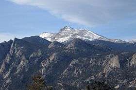 Mummy Mountain from Estes Park, Colorado. | |
| Highest point | |
| Elevation | 13,430 ft (4,093 m) [1][2] |
| Prominence | 485 ft (148 m) [2] |
| Isolation | 1.37 mi (2.20 km) [2] |
| Coordinates | 40°28′30″N 105°37′25″W / 40.4749834°N 105.6236132°WCoordinates: 40°28′30″N 105°37′25″W / 40.4749834°N 105.6236132°W [3] |
| Geography | |
 Mummy Mountain | |
| Location | Larimer County Colorado, U.S.[3] |
| Parent range | Mummy Range[2] |
| Topo map |
USGS 7.5' topographic map Estes Park, Colorado[3] |
| Climbing | |
| Easiest route | hike |
Mummy Mountain is a high mountain summit in the Mummy Range of the Rocky Mountains of North America. The 13,430-foot (4,093 m) thirteener is located in the Rocky Mountain National Park Wilderness, 8.5 miles (13.7 km) northwest by north (bearing 323°) of the Town of Estes Park in Larimer County, Colorado, United States.[1][2][3]
Mountain
See also
References
- 1 2 The elevation of Mummy Mountain includes an adjustment of +1.644 m (+5.39 ft) from NGVD 29 to NAVD 88.
- 1 2 3 4 5 "Mummy Mountain, Colorado". Peakbagger.com. Retrieved November 6, 2014.
- 1 2 3 4 "Mummy Mountain". Geographic Names Information System. United States Geological Survey. Retrieved November 6, 2014.
External links

This article is issued from
Wikipedia.
The text is licensed under Creative Commons - Attribution - Sharealike.
Additional terms may apply for the media files.