Greer Township, Warrick County, Indiana
Greer Township is one of ten townships in Warrick County, Indiana, United States. As of the 2010 census, its population was 1,883 and it contained 769 housing units.[1]
Greer Township Warrick County | |
|---|---|
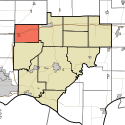 Location in Warrick County | |
| Coordinates: 38°10′24″N 87°24′45″W | |
| Country | United States |
| State | Indiana |
| County | Warrick |
| Government | |
| • Type | Indiana township |
| Area | |
| • Total | 27.54 sq mi (71.3 km2) |
| • Land | 27.17 sq mi (70.4 km2) |
| • Water | 0.37 sq mi (1.0 km2) 1.34% |
| Elevation | 394 ft (120 m) |
| Population (2010) | |
| • Total | 1,883 |
| • Density | 69.3/sq mi (26.8/km2) |
| ZIP codes | 47613, 47619, 47639 |
| GNIS feature ID | 453356 |
History
Greer Township was organized in 1853.[2] The township was named for Richard Greer, a pioneer settler.[3]
Geography
According to the 2010 census, the township has a total area of 27.54 square miles (71.3 km2), of which 27.17 square miles (70.4 km2) (or 98.66%) is land and 0.37 square miles (0.96 km2) (or 1.34%) is water.[1]
Cities, towns, villages
Unincorporated towns
(This list is based on USGS data and may include former settlements.)
Adjacent townships
- Barton Township, Gibson County (north)
- Hart Township (east)
- Campbell Township (south)
- Johnson Township, Gibson County (west)
- Scott Township, Vanderburgh County (west)
Cemeteries
The township contains these four cemeteries: Northview, Susott, Williams and Zion.
School districts
- Warrick County School Corporation
Political districts
- Indiana's 8th congressional district
- State House District 75
- State Senate District 50
References
- United States Census Bureau 2007 TIGER/Line Shapefiles
- United States Board on Geographic Names (GNIS)
- IndianaMap
- "Population, Housing Units, Area, and Density: 2010 - County -- County Subdivision and Place -- 2010 Census Summary File 1". United States Census. Archived from the original on 2020-02-12. Retrieved 2013-05-10.
- History of Warrick, Spencer, and Perry Counties, Indiana: From the Earliest Time to the Present. Goodspeed. 1885. p. 30.
- Fortune, William (1881). Warrick and Its Prominent People: A History of Warrick County, Indiana from the Time of Its Organization and Settlement. Courier Company. p. 19.
External links
Municipalities and communities of Warrick County, Indiana, United States | ||
|---|---|---|
| City | Map of Indiana highlighting Warrick County | |
| Towns | ||
| Townships | ||
| Unincorporated communities |
| |
This article is issued from Wikipedia. The text is licensed under Creative Commons - Attribution - Sharealike. Additional terms may apply for the media files.