Liberty Township, Hendricks County, Indiana
Liberty Township is one of twelve townships in Hendricks County, Indiana, United States. As of the 2010 census, its population was 5,772.[1]
Liberty Township | |
|---|---|
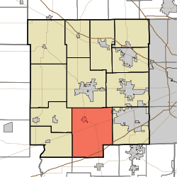 Location in Hendricks County | |
| Coordinates: 39°40′13″N 86°29′52″W | |
| Country | United States |
| State | Indiana |
| County | Hendricks |
| Government | |
| • Type | Indiana township |
| Area | |
| • Total | 49.48 sq mi (128.14 km2) |
| • Land | 49.46 sq mi (128.11 km2) |
| • Water | 0.01 sq mi (0.03 km2) 0.02% |
| Elevation | 860 ft (262 m) |
| Population (2010) | |
| • Total | 5,772 |
| • Density | 116.7/sq mi (45.1/km2) |
| GNIS feature ID | 0453555 |
Geography
Liberty Township covers an area of 49.48 square miles (128.2 km2); of this, 0.01 square miles (0.026 km2) or 0.02 percent is water. The stream of Cosner Branch runs through this township.
Cities and towns
- Clayton
- Plainfield (west edge)
Unincorporated towns
- Belleville
- Cartersburg
- Center Valley
- Hazelwood
- Magnetic Springs
- North Belleville
- Summit
- Hello, Indiana
(This list is based on USGS data and may include former settlements.)
Adjacent townships
- Center Township (north)
- Washington Township (northeast)
- Guilford Township (east)
- Monroe Township, Morgan County (south)
- Adams Township, Morgan County (southwest)
- Clay Township (west)
- Franklin Township (west)
Cemeteries
The township contains twelve cemeteries: Buchanan, Center Valley Friendship Baptist, Clayton, Davis, Friendship Missionary Baptist, Irons, Jones, McCormack, Miles, Salem Methodist, Spring Hill and Ungles.
Major highways


Airports and landing strips
- Cooper Airport 05IN
Education
Liberty Township residents may obtain a free library card from the Clayton-Liberty Township Public Library in Clayton.[2]
References
- "Liberty Township, Hendricks County, Indiana". Geographic Names Information System. United States Geological Survey. Retrieved 2009-09-24.
- United States Census Bureau cartographic boundary files
- "U.S. Census website". Retrieved 2008-07-20.
- "Library cards". Clayton-Liberty Twp Public Library. Retrieved 7 March 2018.
External links
Municipalities and communities of Hendricks County, Indiana, United States | ||
|---|---|---|
| Towns | Map of Indiana highlighting Hendricks County | |
| Townships | ||
| Unincorporated communities | ||
| Footnotes | ‡This populated place also has portions in an adjacent county or counties | |
This article is issued from Wikipedia. The text is licensed under Creative Commons - Attribution - Sharealike. Additional terms may apply for the media files.