Vias, Hérault
| Vias | ||
|---|---|---|
| Commune | ||
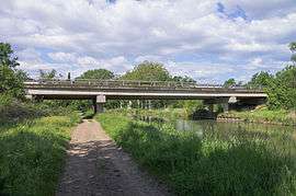 Bridge over the Canal du Midi | ||
| ||
 Vias Location within Occitanie region  Vias | ||
| Coordinates: 43°18′49″N 3°25′09″E / 43.3136°N 3.4192°ECoordinates: 43°18′49″N 3°25′09″E / 43.3136°N 3.4192°E | ||
| Country | France | |
| Region | Occitanie | |
| Department | Hérault | |
| Arrondissement | Béziers | |
| Canton | Agde | |
| Intercommunality | Hérault Méditerranée | |
| Government | ||
| • Mayor (2008–2014) | Richard Monedero | |
| Area1 | 32.49 km2 (12.54 sq mi) | |
| Population (2008)2 | 5,422 | |
| • Density | 170/km2 (430/sq mi) | |
| Time zone | UTC+1 (CET) | |
| • Summer (DST) | UTC+2 (CEST) | |
| INSEE/Postal code | 34332 /34450 | |
| Elevation |
0–33 m (0–108 ft) (avg. 5 m or 16 ft) | |
|
1 French Land Register data, which excludes lakes, ponds, glaciers > 1 km2 (0.386 sq mi or 247 acres) and river estuaries. 2 Population without double counting: residents of multiple communes (e.g., students and military personnel) only counted once. | ||
.svg.png)
Vias is a commune in the Hérault department in the Occitanie region in southern France.
It is a popular holiday destination with many camp and caravan sites. The Canal du midi passes close to the town at the site of the canal crossing the river Libron, an interesting historic engineering work.
.jpg) A boat on the Canal du Midi
A boat on the Canal du Midi
Population
| Historical population | ||
|---|---|---|
| Year | Pop. | ±% |
| 1962 | 2,216 | — |
| 1968 | 2,364 | +6.7% |
| 1975 | 2,582 | +9.2% |
| 1982 | 2,934 | +13.6% |
| 1990 | 3,517 | +19.9% |
| 1999 | 4,354 | +23.8% |
| 2008 | 5,422 | +24.5% |
Energy
Around 17% of the commune's electricity is provided by local solar power installations.
See also
References
External links
| Wikimedia Commons has media related to Vias. |
This article is issued from
Wikipedia.
The text is licensed under Creative Commons - Attribution - Sharealike.
Additional terms may apply for the media files.