Loupian
| Loupian | ||
|---|---|---|
| Commune | ||
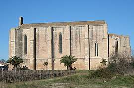 Church of Sainte-Cécile | ||
| ||
 Loupian Location within Occitanie region  Loupian | ||
| Coordinates: 43°27′03″N 3°36′52″E / 43.4508°N 3.6144°ECoordinates: 43°27′03″N 3°36′52″E / 43.4508°N 3.6144°E | ||
| Country | France | |
| Region | Occitanie | |
| Department | Hérault | |
| Arrondissement | Montpellier | |
| Canton | Mèze | |
| Intercommunality | CA Bassin de Thau | |
| Government | ||
| • Mayor (2014–2020) | Alain Vidal | |
| Area1 | 16.00 km2 (6.18 sq mi) | |
| Population (2008)2 | 2,085 | |
| • Density | 130/km2 (340/sq mi) | |
| Time zone | UTC+1 (CET) | |
| • Summer (DST) | UTC+2 (CEST) | |
| INSEE/Postal code | 34143 /34140 | |
| Elevation |
0–170 m (0–558 ft) (avg. 2 m or 6.6 ft) | |
|
1 French Land Register data, which excludes lakes, ponds, glaciers > 1 km2 (0.386 sq mi or 247 acres) and river estuaries. 2 Population without double counting: residents of multiple communes (e.g., students and military personnel) only counted once. | ||
.svg.png)
Loupian is a commune in the Hérault département in southern France.
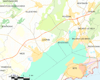
Map
Population
| Historical population | ||
|---|---|---|
| Year | Pop. | ±% |
| 1962 | 871 | — |
| 1968 | 901 | +3.4% |
| 1975 | 934 | +3.7% |
| 1982 | 1,113 | +19.2% |
| 1990 | 1,289 | +15.8% |
| 1999 | 1,483 | +15.1% |
| 2008 | 2,085 | +40.6% |
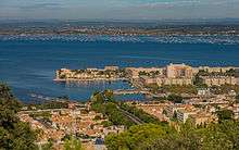
Loupian and the Étang de Thau from Sète.
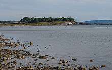
"Saint-Félix" and the Étang de Thau.
See also
References
| Wikimedia Commons has media related to Loupian. |
| Authority control |
|---|
This article is issued from
Wikipedia.
The text is licensed under Creative Commons - Attribution - Sharealike.
Additional terms may apply for the media files.