Le Crès
| Le Crès | ||
|---|---|---|
| Commune | ||
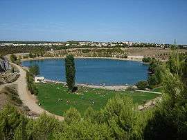 Lake | ||
| ||
 Le Crès Location within Occitanie region  Le Crès | ||
| Coordinates: 43°38′53″N 3°56′23″E / 43.6481°N 3.9397°ECoordinates: 43°38′53″N 3°56′23″E / 43.6481°N 3.9397°E | ||
| Country | France | |
| Region | Occitanie | |
| Department | Hérault | |
| Arrondissement | Montpellier | |
| Canton | Le Crès | |
| Intercommunality | Montpellier Méditerranée Métropole | |
| Government | ||
| • Mayor (2008–2014) | Pierre Bonnal | |
| Area1 | 5.84 km2 (2.25 sq mi) | |
| Population (2008)2 | 7,259 | |
| • Density | 1,200/km2 (3,200/sq mi) | |
| Time zone | UTC+1 (CET) | |
| • Summer (DST) | UTC+2 (CEST) | |
| INSEE/Postal code | 34090 /34920 | |
| Elevation |
29–83 m (95–272 ft) (avg. 70 m or 230 ft) | |
|
1 French Land Register data, which excludes lakes, ponds, glaciers > 1 km2 (0.386 sq mi or 247 acres) and river estuaries. 2 Population without double counting: residents of multiple communes (e.g., students and military personnel) only counted once. | ||
.svg.png)
Le Crès is a commune in the Hérault department in southern France.
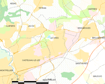
Map
The town has three football stadiums and a secondary school. Every year there is a village party with bulls in the arena and in the streets.
See also
References
| Wikimedia Commons has media related to Le Crès. |
This article is issued from
Wikipedia.
The text is licensed under Creative Commons - Attribution - Sharealike.
Additional terms may apply for the media files.