Campagnan
| Campagnan | ||
|---|---|---|
| Commune | ||
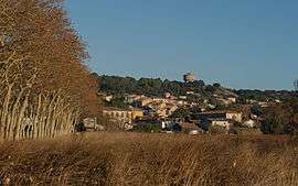 A general view of Campagnan | ||
| ||
 Campagnan Location within Occitanie region  Campagnan | ||
| Coordinates: 43°32′18″N 3°29′55″E / 43.5383°N 3.4986°ECoordinates: 43°32′18″N 3°29′55″E / 43.5383°N 3.4986°E | ||
| Country | France | |
| Region | Occitanie | |
| Department | Hérault | |
| Arrondissement | Lodève | |
| Canton | Gignac | |
| Intercommunality | Vallée de l'Hérault | |
| Government | ||
| • Mayor (2008–2014) | Maurice Dejean | |
| Area1 | 3.75 km2 (1.45 sq mi) | |
| Population (2008)2 | 536 | |
| • Density | 140/km2 (370/sq mi) | |
| Time zone | UTC+1 (CET) | |
| • Summer (DST) | UTC+2 (CEST) | |
| INSEE/Postal code | 34047 /34230 | |
| Elevation |
18–123 m (59–404 ft) (avg. 32 m or 105 ft) | |
|
1 French Land Register data, which excludes lakes, ponds, glaciers > 1 km2 (0.386 sq mi or 247 acres) and river estuaries. 2 Population without double counting: residents of multiple communes (e.g., students and military personnel) only counted once. | ||
.svg.png)
Campagnan is a commune situated in the Hérault Department of Southern France located just 32 kilometres from Montpellier.[1]

Map
Population
| Historical population | ||
|---|---|---|
| Year | Pop. | ±% |
| 1962 | 332 | — |
| 1968 | 310 | −6.6% |
| 1975 | 303 | −2.3% |
| 1982 | 319 | +5.3% |
| 1990 | 329 | +3.1% |
| 1999 | 391 | +18.8% |
| 2008 | 536 | +37.1% |
See also
References
- ↑ Admin. "Campagnan, France (Herault, Languedoc-Roussillon): tourism, attractions and travel guide for Campagnan". www.francethisway.com. Retrieved 2018-01-17.
| Wikimedia Commons has media related to Campagnan. |
This article is issued from
Wikipedia.
The text is licensed under Creative Commons - Attribution - Sharealike.
Additional terms may apply for the media files.