Roquessels
| Roquessels | ||
|---|---|---|
| Commune | ||
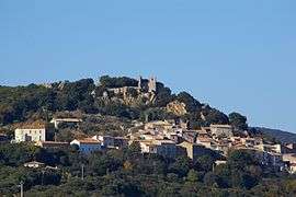 A general view of Roquessels | ||
| ||
 Roquessels Location within Occitanie region  Roquessels | ||
| Coordinates: 43°33′10″N 3°13′27″E / 43.5528°N 3.2242°ECoordinates: 43°33′10″N 3°13′27″E / 43.5528°N 3.2242°E | ||
| Country | France | |
| Region | Occitanie | |
| Department | Hérault | |
| Arrondissement | Béziers | |
| Canton | Cazouls-lès-Béziers | |
| Intercommunality | CC Les Avant-Monts | |
| Government | ||
| • Mayor (2008–2014) | Marcel Buisson | |
| Area1 | 89.8 km2 (34.7 sq mi) | |
| Population (2008)2 | 129 | |
| • Density | 1.4/km2 (3.7/sq mi) | |
| Time zone | UTC+1 (CET) | |
| • Summer (DST) | UTC+2 (CEST) | |
| INSEE/Postal code | 34234 /34320 | |
| Elevation |
138–440 m (453–1,444 ft) (avg. 190 m or 620 ft) | |
|
1 French Land Register data, which excludes lakes, ponds, glaciers > 1 km2 (0.386 sq mi or 247 acres) and river estuaries. 2 Population without double counting: residents of multiple communes (e.g., students and military personnel) only counted once. | ||
.svg.png)
Roquessels is a commune in the Hérault department in the Occitanie region in southern France.
Population
| Historical population | ||
|---|---|---|
| Year | Pop. | ±% |
| 1962 | 110 | — |
| 1968 | 112 | +1.8% |
| 1975 | 115 | +2.7% |
| 1982 | 97 | −15.7% |
| 1990 | 123 | +26.8% |
| 1999 | 123 | +0.0% |
| 2008 | 129 | +4.9% |
Inhabitants of Roquessels are called Roquesselois
Winemaking
Roquessels is one of the seven communes which produces Faugères AOC wine.
Sights
Above the village stands the ruined mediaeval castle, the Château de Roquessels. The castle chapel still stands and is a listed historic site.
See also
References
| Wikimedia Commons has media related to Roquessels. |
| Authority control |
|---|
This article is issued from
Wikipedia.
The text is licensed under Creative Commons - Attribution - Sharealike.
Additional terms may apply for the media files.