Balaruc-les-Bains
| Balaruc-les-Bains | ||
|---|---|---|
| Commune | ||
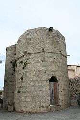 Church ND d'Aix | ||
| ||
 Balaruc-les-Bains Location within Occitanie region  Balaruc-les-Bains | ||
| Coordinates: 43°26′30″N 3°40′40″E / 43.4417°N 3.6778°ECoordinates: 43°26′30″N 3°40′40″E / 43.4417°N 3.6778°E | ||
| Country | France | |
| Region | Occitanie | |
| Department | Hérault | |
| Arrondissement | Montpellier | |
| Canton | Frontignan | |
| Intercommunality | Bassin de Thau | |
| Government | ||
| • Mayor (2008–2014) | Gérard Canovas | |
| Area1 | 8.66 km2 (3.34 sq mi) | |
| Population (2008)2 | 6,376 | |
| • Density | 740/km2 (1,900/sq mi) | |
| Time zone | UTC+1 (CET) | |
| • Summer (DST) | UTC+2 (CEST) | |
| INSEE/Postal code | 34023 /34540 | |
| Elevation |
0–169 m (0–554 ft) (avg. 3 m or 9.8 ft) | |
|
1 French Land Register data, which excludes lakes, ponds, glaciers > 1 km2 (0.386 sq mi or 247 acres) and river estuaries. 2 Population without double counting: residents of multiple communes (e.g., students and military personnel) only counted once. | ||
.svg.png)
Balaruc-les-Bains is a commune in the Hérault department in the Occitanie region in southern France.
Population
| Historical population | ||
|---|---|---|
| Year | Pop. | ±% |
| 1962 | 1,822 | — |
| 1968 | 1,830 | +0.4% |
| 1975 | 2,957 | +61.6% |
| 1982 | 4,369 | +47.8% |
| 1990 | 5,013 | +14.7% |
| 1999 | 5,688 | +13.5% |
| 2008 | 6,376 | +12.1% |

Map

From La Gardiole Mountain.
See also
References
| Wikimedia Commons has media related to Balaruc-les-Bains. |
This article is issued from
Wikipedia.
The text is licensed under Creative Commons - Attribution - Sharealike.
Additional terms may apply for the media files.