Mérifons
| Mérifons | |
|---|---|
| Commune | |
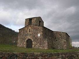 Church Saint-Pierre-es-Liens | |
 Mérifons Location within Occitanie region  Mérifons | |
| Coordinates: 43°38′08″N 3°17′10″E / 43.6356°N 3.2861°ECoordinates: 43°38′08″N 3°17′10″E / 43.6356°N 3.2861°E | |
| Country | France |
| Region | Occitanie |
| Department | Hérault |
| Arrondissement | Lodève |
| Canton | Clermont-l'Hérault |
| Intercommunality | Clermontais |
| Government | |
| • Mayor (2008–2014) | Daniel Viala |
| Area1 | 6.74 km2 (2.60 sq mi) |
| Population (2008)2 | 47 |
| • Density | 7.0/km2 (18/sq mi) |
| Time zone | UTC+1 (CET) |
| • Summer (DST) | UTC+2 (CEST) |
| INSEE/Postal code | 34156 /34800 |
| Elevation |
157–452 m (515–1,483 ft) (avg. 180 m or 590 ft) |
|
1 French Land Register data, which excludes lakes, ponds, glaciers > 1 km2 (0.386 sq mi or 247 acres) and river estuaries. 2 Population without double counting: residents of multiple communes (e.g., students and military personnel) only counted once. | |
Mérifons is a commune in the Hérault department in southern France.

Map
Population
| Historical population | ||
|---|---|---|
| Year | Pop. | ±% |
| 1962 | 28 | — |
| 1968 | 47 | +67.9% |
| 1975 | 42 | −10.6% |
| 1982 | 29 | −31.0% |
| 1990 | 29 | +0.0% |
| 1999 | 26 | −10.3% |
| 2008 | 47 | +80.8% |
See also
References
| Wikimedia Commons has media related to Mérifons. |
This article is issued from
Wikipedia.
The text is licensed under Creative Commons - Attribution - Sharealike.
Additional terms may apply for the media files.