Espondeilhan
| Espondeilhan | ||
|---|---|---|
| Commune | ||
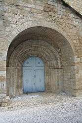 Notre Dame des Pins | ||
| ||
 Espondeilhan Location within Occitanie region  Espondeilhan | ||
| Coordinates: 43°26′28″N 3°15′47″E / 43.4411°N 3.2631°ECoordinates: 43°26′28″N 3°15′47″E / 43.4411°N 3.2631°E | ||
| Country | France | |
| Region | Occitanie | |
| Department | Hérault | |
| Arrondissement | Béziers | |
| Canton | Béziers-3 | |
| Intercommunality | Béziers Méditerranée | |
| Government | ||
| • Mayor (2008–2014) | Alain Romero | |
| Area1 | 5.08 km2 (1.96 sq mi) | |
| Population (2008)2 | 922 | |
| • Density | 180/km2 (470/sq mi) | |
| Time zone | UTC+1 (CET) | |
| • Summer (DST) | UTC+2 (CEST) | |
| INSEE/Postal code | 34094 /34290 | |
| Elevation |
60–123 m (197–404 ft) (avg. 60 m or 200 ft) | |
|
1 French Land Register data, which excludes lakes, ponds, glaciers > 1 km2 (0.386 sq mi or 247 acres) and river estuaries. 2 Population without double counting: residents of multiple communes (e.g., students and military personnel) only counted once. | ||
.svg.png)
Espondeilhan is a commune in the Hérault department in southern France.

Map
Population
| Historical population | ||
|---|---|---|
| Year | Pop. | ±% |
| 1962 | 316 | — |
| 1968 | 354 | +12.0% |
| 1975 | 323 | −8.8% |
| 1982 | 356 | +10.2% |
| 1990 | 517 | +45.2% |
| 1999 | 623 | +20.5% |
| 2008 | 922 | +48.0% |
See also
References
| Wikimedia Commons has media related to Espondeilhan. |
This article is issued from
Wikipedia.
The text is licensed under Creative Commons - Attribution - Sharealike.
Additional terms may apply for the media files.