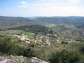
Dio-et-Valquières
| Dio-et-Valquières | ||
|---|---|---|
| Commune | ||
 Dio | ||
| ||
 Dio-et-Valquières Location within Occitanie region  Dio-et-Valquières | ||
| Coordinates: 43°40′06″N 3°14′02″E / 43.6683°N 3.2339°ECoordinates: 43°40′06″N 3°14′02″E / 43.6683°N 3.2339°E | ||
| Country | France | |
| Region | Occitanie | |
| Department | Hérault | |
| Arrondissement | Béziers | |
| Canton | Clermont-l'Hérault | |
| Intercommunality | Avène, Orb et Gravezon | |
| Government | ||
| • Mayor (2008–2014) | Jean-Paul Arnaud | |
| Area1 | 18.77 km2 (7.25 sq mi) | |
| Population (2008)2 | 158 | |
| • Density | 8.4/km2 (22/sq mi) | |
| Time zone | UTC+1 (CET) | |
| • Summer (DST) | UTC+2 (CEST) | |
| INSEE/Postal code | 34093 /34650 | |
| Elevation |
256–701 m (840–2,300 ft) (avg. 250 m or 820 ft) | |
|
1 French Land Register data, which excludes lakes, ponds, glaciers > 1 km2 (0.386 sq mi or 247 acres) and river estuaries. 2 Population without double counting: residents of multiple communes (e.g., students and military personnel) only counted once. | ||
.svg.png)
Dio-et-Valquières is a commune in the Hérault department in southern France.

Map
Population
| Historical population | ||
|---|---|---|
| Year | Pop. | ±% |
| 1962 | 62 | — |
| 1968 | 70 | +12.9% |
| 1975 | 66 | −5.7% |
| 1982 | 98 | +48.5% |
| 1990 | 134 | +36.7% |
| 1999 | 136 | +1.5% |
| 2008 | 158 | +16.2% |
See also
References
| Wikimedia Commons has media related to Dio-et-Valquières. |
| Authority control |
|---|
This article is issued from
Wikipedia.
The text is licensed under Creative Commons - Attribution - Sharealike.
Additional terms may apply for the media files.