Aumes
| Aumes | ||
|---|---|---|
| Commune | ||
 A general view of Aumes | ||
| ||
 Aumes Location within Occitanie region  Aumes | ||
| Coordinates: 43°28′01″N 3°27′49″E / 43.4669°N 3.4636°ECoordinates: 43°28′01″N 3°27′49″E / 43.4669°N 3.4636°E | ||
| Country | France | |
| Region | Occitanie | |
| Department | Hérault | |
| Arrondissement | Béziers | |
| Canton | Mèze | |
| Intercommunality | CA Hérault Méditerranée | |
| Government | ||
| • Mayor (2014-2020) | Jean-Marie At | |
| Area1 | 7.39 km2 (2.85 sq mi) | |
| Population (2015)2 | 485 | |
| • Density | 66/km2 (170/sq mi) | |
| Time zone | UTC+1 (CET) | |
| • Summer (DST) | UTC+2 (CEST) | |
| INSEE/Postal code | 34017 /34530 | |
| Elevation |
6–106 m (20–348 ft) (avg. 80 m or 260 ft) | |
|
1 French Land Register data, which excludes lakes, ponds, glaciers > 1 km2 (0.386 sq mi or 247 acres) and river estuaries. 2 Population without double counting: residents of multiple communes (e.g., students and military personnel) only counted once. | ||
.svg.png)
Aumes is a commune in the Hérault department in southern France. Guillaume d’Abbes de Cabrebolles (1718–1802), Encyclopédiste, died in Aumes.
Population
| Historical population | ||
|---|---|---|
| Year | Pop. | ±% |
| 1962 | 267 | — |
| 1968 | 310 | +16.1% |
| 1975 | 305 | −1.6% |
| 1982 | 286 | −6.2% |
| 1990 | 268 | −6.3% |
| 1999 | 310 | +15.7% |
| 2008 | 420 | +35.5% |
| 2015 | 485 | +15.5% |
Images
 Well
Well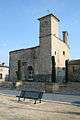 Church St-Pierre
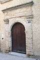 Door of the presbytery.
 Church of St. Aubin
 Castle Saint Martin de Graves.
See also
References
| Wikimedia Commons has media related to Aumes. |
This article is issued from
Wikipedia.
The text is licensed under Creative Commons - Attribution - Sharealike.
Additional terms may apply for the media files.